
Bassingham
About Bassingham
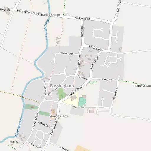
Bassingham sits within Lincolnshire. Neighbouring places include Carlton-le-Moorland only 2.0 km South South West, Norton Disney lying 2.6 km West South West, Aubourn lying 2.6 km North North East, Witham St Hughs lying 2.9 km North West and Stapleford lying 3.7 km South West. Other nearby hamlets and settlements include Thurlby, Haddington, Morton and Morton Hall.
You may find extra local information by clicking a nearby place.
These details are compiled from OS, ONS and OSM data released under open licence.
⇅
Local Map
⇅
Location Summary
- Bassingham is located in Lincolnshire
- Administrative Area: Lincolnshire
- Ceremonial County: Lincolnshire
- Historic County: Lincolnshire
- Region & Country: East Midlands / England
⇅
Nearby Towns & Cities
- North Hykeham
- Newark-on-Trent
- Sleaford
- Southwell
- Lincoln
⇅
Nearby Localities
⇅
Smaller Settlements
- Thurlby
- Haddington
- Morton
- Morton Hall
- Eagle Barnsdale
- Brough
- Eagle Hall
- Redmay Corner
- Stragglethorpe
- Sutton
⇅
Beaches
- Cleethorpes Beach
- Humberston Fitties Beach
- Tetney High Sands
⇅
Parks
- Bulwell Forest
- Burgage Green
- Killamarsh Meadows
- Wilsford Warren
⇅
Woods
- Bassingham Covert
- Cherry Holt
- Fox Covert
- Killbuck Plantation
⇅
Hills
- Beacon Hill
- Danethorpe Hill
- Hop Hill
- Potter Hill
⇅
Lakes
- Horse Pool
- Joyce's Broad
- Richmond Lakes
- Swanholme Lakes
⇅
Waterfalls
- Goitstock Waterfall
- Kinder Downfall
- Lumb Fall
⇅
Headlands
- Flamborough Head
- Red Cliff Point
⇅
Islands
- Branston Island
- Torksey Island
⇅
Wetlands
- Smithy Marsh
- Laughterton Marsh
- Guildhall Springs
⇅
Health Services
- Newark Hospital
- Lincoln Private Hospital
- Courtlands Lodge
- St Michael's Nursing Home
⇅
Education
- Bassingham Primary School
- Witham Prospect School
- University of Lincoln
⇅
Railway Stations
- Swinderby
- Collingham
⇅
Bus Stations
- Lincoln Central Bus Station
- Newark Bus Station
⇅
Coach Stations
- Chesterfield Coach Station
- Meadowhall Interchange
⇅
Ferry Terminals
- Normanton Chain Ferry
- Hull Ferry Port
⇅
Airports
- Wickenby Aerodrome
- Nottingham City Airport
⇅
Airfields
- RAF Waddington
- RAF Cranwell
⇅
Heliports
- Lincs and Notts Air Ambulance HQ
- Nottingham Heliport
⇅
Harbours
- Farndon Harbour
- South Killingholme Haven