
Berry Pomeroy
About Berry Pomeroy
Berry Pomeroy, in Devon, has Bridgetown just 2.0 km West South West, Beechdown just 2.9 km East South East, Little Blagdon only 3.0 km East South East, Collaton St Mary situated 3.1 km East South East and Dartington just 4.0 km West. Other rural localities include True Street, Gatcombe Mill, Higher Blagdon and Littlehempston.
You might discover something new by clicking a nearby place for more local details.
These details are compiled from OS, ONS and OSM data released under open licence.
⇅
Local Map
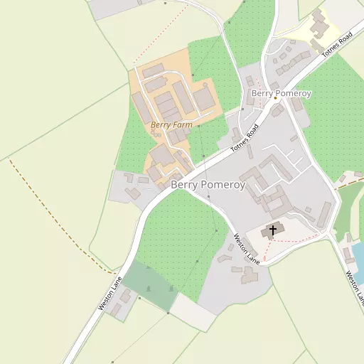
⇅
Location Summary
- Berry Pomeroy is located in Devon
- Administrative Area: Devon
- Ceremonial County: Devon
- Historic County: Devon
- Region & Country: South West / England
⇅
Nearby Towns & Cities
- Totnes 2.6 km WSW
- Paignton 6.0 km E
- Torquay 9.2 km ENE
- Buckfastleigh 10.1 km WNW
- Exeter 32.8 km NNE


⇅
Nearby Localities
- BridgetownDistrict 2.0 km WSW
- BeechdownDistrict 2.9 km ESE
- Little BlagdonDistrict 3.0 km ESE
- Collaton St MaryVillage 3.1 km ESE
- DartingtonVillage 4.0 km W
- Higher YalbertonDistrict 4.0 km ESE
- CottDistrict 4.0 km W
- AshpringtonVillage 4.1 km SSW
- Stoke GabrielVillage 4.4 km SSE
- TweenawaysDistrict 4.5 km ESE


⇅
Smaller Settlements
- True Street 847 m SW
- Gatcombe Mill 1.6 km NNW
- Higher Blagdon 2.5 km E
- Littlehempston 2.5 km NW
- Aish 2.6 km SE
- Lower Blagdon 3.0 km E
- Longcause 3.6 km W
- Bow 4.7 km SSW
- Torbryan 5.8 km N
- Dainton 6.1 km NNE


⇅
Beaches
- Goodrington Sands North6.8 km E
- Goodrington Sands South6.8 km ESE
- Paignton Sands6.7 km E
⇅
Parks
- Palm Cross Green19.5 km WSW
- Pennsylvania Park34.6 km NNE
- Pleasure Grounds41.0 km NW
- The Lawn20.5 km NE

⇅
Woods
- Broadmoor Plantation618 m WNW
- Martin Torre Wood645 m SSW
- Southfield Wood671 m S
- Westfield Wood444 m WSW

⇅
Hills
- Ackerlls Hill1.9 km NNW
- Beacon Hill3.2 km ENE
- Silver Head Hill1.9 km NW
- Windmill Hill3.1 km ESE
⇅
Lakes
- Aptor Pool3.6 km NE
- Mill Pool4.6 km SSE
- Old Mill Leat5.5 km S
- St Peter's Quay Pool2.4 km WSW
⇅
Waterfalls
- Becka Falls20.1 km NNW
- Broad Falls18.4 km WNW
- Horseshoe Falls15.0 km NW
⇅
Headlands
- Ashprington Point3.9 km SSE
- Sharpham Point3.2 km S
⇅
Islands
- Snipe Island2.2 km W
- Vire Island2.3 km WSW
⇅
Wetlands
- The Gut3.0 km S
- Stoke Point4.4 km SSE
- Mill Point4.8 km SSE
⇅
Health Services
- Totnes HospitalHospital 2.4 km WSW
- Torbay HospitalHospital 8.5 km NE
- Primley Court Care HomeMedical 5.5 km E
- Mount Olivet Nursing HomeMedical 6.8 km ENE
⇅
Education
- Berry Pomeroy Parochial Church of England Primary SchoolSchool 310 m NE
- Totnes St John's Church of England Primary SchoolSchool 2.0 km WSW
- Schumacher CollegeUniversity 4.4 km WNW
⇅
Railway Stations
- Totnes2.4 km W
- Totnes2.6 km W
⇅
Bus Stations
- Kingsbridge Bus Station19.3 km SSW
- Exeter Bus Station33.3 km NNE
⇅
Coach Stations
- Torquay Coach Station9.1 km ENE
- Plymouth Coach Station35.6 km WSW
⇅
Ferry Terminals
- Greenway Quay7.5 km SE
- Kingswear Hoodown10.3 km SSE
⇅
Airports
- Plymouth City Airport32.4 km W
- Exeter Airport37.1 km NNE
⇅
Airfields
- Bolt Head Airfield25.9 km SSW
- Farway Common Airfield47.1 km NE
⇅
Heliports
- Lake Heliport78.4 km NNW
- Hartland Heliport88.8 km NW
⇅
Harbours
- Paignton Harbour6.8 km E
- New Harbour9.1 km ENE