
Buck's Cross
About Buck's Cross
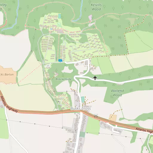
Buck's Cross is in Devon. Among the nearby places are Buck's Mills around 908 m East North East, Woolfardisworthy situated 2.6 km South West, Clovelly situated 3.7 km West North West and Horns Cross just 3.7 km East. Other rural areas close to here include Cranford, West Town, Parkham Ash, Holwell and Alminstone Cross.
You might learn something new by clicking through to a nearby place.
All information is drawn from OS, ONS and OSM under open licence, reflecting the best available public data.
⇅
Local Map
⇅
Location Summary
- Buck's Cross is located in Devon
- Administrative Area: Devon
- Ceremonial County: Devon
- Historic County: Devon
- Region & Country: South West / England
⇅
Nearby Towns & Cities
- Bideford 11.1 km ENE
- Northam 11.7 km ENE
- Great Torrington 15.2 km ESE
- Holsworthy 19.3 km S
- Exeter 64.6 km ESE


⇅
Nearby Localities
- Buck's MillsVillage 908 m ENE
- WoolfardisworthyVillage 2.6 km SW
- ClovellyVillage 3.7 km WNW
- Horns CrossVillage 3.7 km E
- Higher ClovellyVillage 3.8 km WNW
- ParkhamVillage 4.4 km ESE
- Fairy CrossVillage 5.7 km ENE
- FordVillage 6.2 km ENE
- Buckland BrewerVillage 7.5 km ESE
- AbbotshamVillage 8.3 km ENE


⇅
Smaller Settlements
- Cranford 1.6 km S
- West Town 2.8 km SW
- Parkham Ash 2.9 km SE
- Holwell 2.9 km E
- Alminstone Cross 3.0 km S
- Northway 3.3 km E
- Venn 3.5 km SSW
- Goldworthy 4.4 km E
- Newhaven 4.6 km E
- Ashmansworthy 5.2 km S


⇅
Beaches
- Mouthmill Beach6.3 km WNW
- Speke's Mill Beach12.4 km W
- Westward Ho! Beach11.0 km NE


⇅
Parks
- Pennsylvania Park64.6 km ESE
- Pleasure Grounds37.4 km SE
- Summerleaze Down21.5 km SW
- The Warren32.6 km NE
⇅
Woods
- Keivill's Wood621 m NNE
- Loggins Wood622 m E
- Longtree Wood346 m E
- Walland Wood650 m E

⇅
Hills
- Andrew's Hill9.6 km W
- Badgers Hill9.1 km ENE
- Melbury Hill4.9 km SE
- Stanbury Acre Point9.0 km WNW
⇅
Lakes
- Canns Water3.9 km SSE
- Cranford Water2.2 km SSW
- Gauter Pool1.9 km ENE
- Melbury Reservoir4.8 km SE

⇅
Waterfalls
- Becka Falls59.6 km SE
- Golitha Falls55.9 km S
- White Lady Waterfall42.5 km SSE
⇅
Headlands
- Cockington Head6.0 km ENE
- Gallantry Bower5.2 km WNW
⇅
Islands
- Chapel Rock22.1 km SW
- Horsey Island16.7 km NE
⇅
Wetlands
- Portledge Mouth4.1 km ENE
- Snuffy Corner12.4 km ENE
- South Gut12.8 km NE
⇅
Health Services
- Bideford Community HospitalHospital 10.7 km ENE
- Torrington Community HospitalHospital 15.6 km ESE
- Golden SandsMedical 10.2 km NE
- Bluebell HouseMedical 10.6 km NE
⇅
Education
- Atlantic AcademySchool 958 m ESE
- Woolsery Primary SchoolSchool 2.8 km SW
- PetrocUniversity 21.3 km ENE
⇅
Railway Stations
- Barnstaple22.7 km ENE
- Chapelton23.4 km E
⇅
Bus Stations
- Barnstaple Bus Station23.4 km ENE
- Exeter Bus Station65.0 km ESE
⇅
Coach Stations
- Plymouth Coach Station69.6 km SSE
- Torquay Coach Station80.8 km SE
⇅
Ferry Terminals
- Torpoint Ferry Terminal68.6 km S
- Plymouth Stonehouse70.1 km S
⇅
Airports
- Plymouth City Airport64.7 km SSE
- Swansea Airport71.6 km NNE
⇅
Airfields
- Belle Vue Airfield18.3 km E
- Chivenor Airfield18.5 km NE
⇅
Heliports
- Lake Heliport9.0 km NE
- Hartland Heliport12.0 km WNW
⇅
Harbours
- Lynmouth Harbour45.8 km NE
- Weston Mill Lake66.8 km S