
Chaffcombe
About Chaffcombe
Chaffcombe is in Somerset. Nearby places include Furnham lying 2.5 km West South West, Dowlish Wake situated 3.4 km North East, Dowlish Ford only 3.4 km North North East and Jocelyn Park situated 3.4 km South West. Other places in the surrounding countryside include Lydmarsh, Knowle St Giles, Cricket Malherbie, Hornsbury and New England.
You may find out something new or interesting if you click a nearby place to see more local information.
The details shown here use OS, ONS and OSM data provided under open licence.
⇅
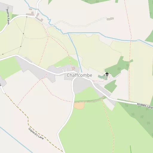
Local Map
⇅
Location Summary
- Chaffcombe is located in Somerset
- Administrative Area: Somerset
- Ceremonial County: Somerset
- Historic County: Somerset
- Region & Country: South West / England
⇅
Nearby Towns & Cities
- Chard 3.5 km WSW
- Ilminster 4.6 km N
- Crewkerne 8.9 km E
- South Petherton 10.4 km NE
- Wells 40.6 km NNE


⇅
Nearby Localities
- FurnhamDistrict 2.5 km WSW
- Dowlish WakeVillage 3.4 km NE
- Dowlish FordVillage 3.4 km NNE
- Jocelyn ParkDistrict 3.4 km SW
- HolbearDistrict 3.4 km SW
- FortonVillage 3.5 km SSW
- CrimchardDistrict 3.6 km WSW
- WadefordVillage 4.0 km W
- DonyattVillage 4.1 km NNW
- KingstoneVillage 4.1 km NE


⇅
Smaller Settlements
- Lydmarsh 1.4 km SSE
- Knowle St Giles 1.5 km NNW
- Cricket Malherbie 1.7 km NNE
- Hornsbury 1.9 km WNW
- New England 2.3 km W
- Cricket St Thomas 2.5 km SE
- Peasmarsh 2.7 km NNW
- Sea 2.9 km N
- Cudworth 2.9 km E
- Cuttiford's Door 2.9 km W


⇅
Beaches
- Charmouth Beach17.2 km S
- Cobb Gate Beach18.2 km S
- Front Beach18.4 km S

⇅
Parks
- Pennsylvania Park45.3 km WSW
- The Lawn51.4 km SW
- Worle Moor52.1 km N
- Yargrass Green40.4 km NNE
⇅
Woods
- Coronation Spinney176 m ENE
- Cuckoo Park Wood670 m ENE
- Knapps Plantation732 m ESE
- Sprays Hill Copse732 m NNE


⇅
Hills
- Burrows Hill3.0 km NE
- Herne Hill3.7 km N
- Knoll Hill2.3 km ESE
- Sprays Hill965 m NE
⇅
Lakes
- Chard Reservoir1.4 km WSW
- Diana Pond5.6 km ENE
- Great Pond5.4 km S
- Mermaid Pond5.2 km S
⇅
Waterfalls
- Becka Falls66.2 km WSW
- Broad Falls82.0 km WSW
- Horseshoe Falls75.3 km WSW
⇅
Headlands
- Brandy Head37.6 km SW
- Stert Point37.4 km N
⇅
Islands
- Fenning Island37.2 km N
- Stert Island39.1 km N
⇅
Wetlands
- Farway Marsh7.1 km SW
- Champernhayes Marsh13.3 km S
- Cockpits17.3 km S
⇅
Health Services
- Chard and District Community HospitalHospital 2.5 km SW
- Crewkerne HospitalHospital 8.8 km E
- Oak LodgeMedical 3.3 km SW
- Horton Cross Nuring HomeMedical 5.3 km NNW
⇅
Education
- Avishayes Primary SchoolSchool 2.1 km WSW
- The Redstart Primary SchoolSchool 3.1 km WSW
- Architectural Association Hooke ParkUniversity 20.5 km ESE
⇅
Railway Stations
- Crewkerne10.2 km E
- Axminster13.4 km SSW
⇅
Bus Stations
- Taunton Bus Station19.2 km NW
- Exeter Bus Station45.9 km WSW

⇅
Coach Stations
- Torquay Coach Station63.1 km SW
- Millstream Coach Park81.4 km ENE
⇅
Ferry Terminals
- Starcross Pier46.8 km SW
- SS Great Britain Ferry Landing66.2 km NNE
⇅
Airports
- Exeter Airport38.4 km WSW
- Bristol Airport56.9 km NNE
⇅
Airfields
- Royal Navy Air Station Merryfield8.7 km N
- Watchford Farm12.3 km W
⇅
Heliports
- Cardiff City Heliport66.2 km NNW
- Lake Heliport94.5 km W
⇅
Harbours
- Bridport Harbour22.6 km SSE
- Watchet Harbour43.4 km NW