
Combe Down, Bath
About Combe Down
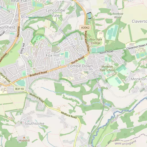
Combe Down is 700 m NW from Bath in the county of Bath and North East Somerset. Places nearby include Fox Hill just 700 m North West, South Stoke situated 874 m South West, Perrymead situated 1.3 km North, Lyncombe Vale only 1.4 km North North West and Midford situated 1.5 km South. Other nearby communities include Tucking Mill, Twinhoe, Pipehouse and Conkwell.
You may notice something interesting if you explore one of the nearby places.
All information is drawn from OS, ONS and OSM under open licence, reflecting the best available public data.
⇅
Local Map
⇅
Location Summary
- Combe Down is a neighbourhood in Bath
- Administrative Area: Bath and North East Somerset
- Ceremonial County: Somerset
- Historic County: Bath and North East Somerset
- Region & Country: South West / England
⇅
Nearby Towns & Cities


⇅
Nearby Localities
- Fox HillDistrict 700 m NW
- South StokeVillage 874 m SW
- PerrymeadDistrict 1.3 km N
- Lyncombe ValeDistrict 1.4 km NNW
- MidfordVillage 1.5 km S
- Bear FlatDistrict 1.7 km NW
- BloomfieldDistrict 1.7 km NW
- Monkton CombeVillage 1.7 km E
- WidcombeDistrict 1.8 km N
- Beechen CliffDistrict 2.0 km NNW


⇅
Smaller Settlements
- Tucking Mill 1.1 km SE
- Twinhoe 2.9 km SSW
- Pipehouse 3.0 km SE
- Conkwell 3.5 km E
- Warleigh 4.2 km ENE
- The Green 4.4 km SSE
- Pinckney Green 4.7 km ENE
- New Town 4.8 km SSE
- Charlcombe 5.1 km NNW
- Farleigh Wick 5.1 km ENE


⇅
Beaches
- Backhill Sands36.3 km WNW
- Cotswold Hills Beach43.2 km NE
- Sugar Loaf Beach33.6 km WNW

⇅
Parks
- Clifton Down22.6 km WNW
- High Common3.8 km NNW
- Lower Common3.4 km NNW
- Pur Down20.3 km NW
⇅
Woods
- Beech Wood429 m SSW
- Free Fields924 m NE
- Priory Wood778 m SSE
- Rainbow Wood1.3 km NE
⇅
Hills
- High Barrow Hill3.4 km WNW
- Hodshill1.7 km SW
- Southdown3.4 km WNW
- Warleigh Hill4.5 km ENE
⇅
Lakes
- Farm Pool10.1 km SSE
- Monkswood Reservoir8.8 km N
- Tucking Mill Reservoir965 m SE
- Weston Cut3.9 km NW
⇅
Waterfalls
- Llech Sychryd88.7 km WNW
- Pwll Annie86.0 km WNW
- Pwll yr Hesg83.2 km NW
⇅
Headlands
- Battery Point33.0 km WNW
- Beachley Point35.0 km NW
⇅
Islands
- Denny Island18.3 km W
- Denny Island35.2 km WNW

⇅
Wetlands
- Hilperton Marsh11.1 km E
- Hollow Marsh15.1 km WSW
- Aucombe Marsh21.4 km SSE

⇅
Health Services
- St Martins HospitalHospital 1.5 km W
- Royal National Hospital for Rheumatic DiseasesHospital 2.7 km NNW
- Midford Manor Care HomeMedical 1.7 km W
- Cedar Park Care CentreMedical 2.4 km NW
⇅
Education
- Combe Down Church of England Voluntary Controlled Primary SchoolSchool 225 m E
- Mulberry ParkSchool 474 m NW
- Bath CollegeUniversity 2.6 km NW
⇅
Railway Stations
- Bath Spa2.1 km NNW
- Oldfield Park3.1 km NW
⇅
Bus Stations
- Chippenham Bus Station19.7 km NE
- Cribbs Causeway Bus Station25.3 km NW
⇅
Coach Stations
- Millstream Coach Park49.9 km SE
- Southampton Coach Station82.7 km SE
⇅
Ferry Terminals
- Harbour Inlet Ferry Landing20.4 km WNW
- SS Great Britain Ferry Landing20.5 km WNW
⇅
Airports
- Bristol Airport25.8 km W
- Cotswold Airport40.0 km NNE

⇅
Airfields
- Colerne Airfield10.3 km NNE
- Wadswick Farm Airfield10.8 km ENE
⇅
Heliports
- Cardiff City Heliport56.0 km WNW
- Lake Heliport137.4 km WSW
⇅
Harbours
- Floating Harbour19.7 km WNW
- Mud Dock19.8 km WNW