
Crackington Haven
About Crackington Haven
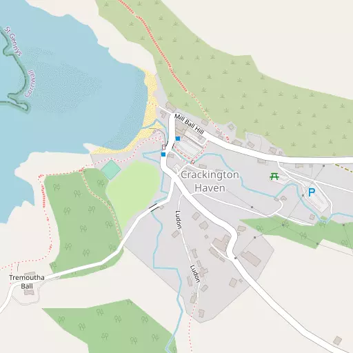
Crackington Haven is in Cornwall. Places nearby include Middle Crackington around 1.4 km South East, Higher Crackington only 1.8 km South East, Wainhouse Corner only 4.1 km East South East and Tresparrett situated 4.9 km South. Other countryside places nearby include St Gennys, Lower Crackington, Tresmorn, Coxford and Hill.
You might learn something new by clicking through to a nearby place.
Information is sourced from OS, ONS and OSM under open licence, using publicly available datasets.
⇅
Local Map
⇅
Location Summary
- Crackington Haven is located in Cornwall
- Administrative Area: Cornwall
- Ceremonial County: Cornwall
- Historic County: Cornwall
- Region & Country: South West / England
⇅
Nearby Towns & Cities
- Bude 11.8 km NNE
- Stratton 13.1 km NE
- Camelford 13.5 km SSW
- Holsworthy 21.1 km ENE
- Plymouth 53.8 km SE


⇅
Nearby Localities
- Middle CrackingtonVillage 1.4 km SE
- Higher CrackingtonVillage 1.8 km SE
- Wainhouse CornerVillage 4.1 km ESE
- TresparrettVillage 4.9 km S
- MarshgateVillage 4.9 km SSE
- JacobstowVillage 5.5 km E
- PoundstockVillage 7.2 km ENE
- BoscastleVillage 7.5 km SSW
- Widemouth BayVillage 7.8 km NE
- WarbstowVillage 8.8 km SE


⇅
Smaller Settlements
- St Gennys 740 m NE
- Lower Crackington 1.8 km ESE
- Tresmorn 1.9 km ENE
- Coxford 1.9 km E
- Hill 2.1 km SSE
- Rosecare 2.5 km ESE
- Pencuke 3.0 km SE
- Tresparrett Posts 3.5 km S
- Trewint 4.4 km ENE
- Tregole 5.1 km ENE
⇅
Beaches
- Crackington Beach282 m NW
- The Strangles1.9 km SW
- Thorn's Beach1.5 km NNE


⇅
Parks
- Palm Cross Green68.1 km SE
- Pleasure Grounds44.8 km E
- Summerleaze Down12.0 km NNE
- The Warren65.9 km NE
⇅
Woods
- East Wood873 m SSW
- Landy Wood4.0 km ENE
- Trengayor Copse3.9 km ENE
- Treworgie Copse3.7 km E
⇅
Hills
- Penally Hill6.9 km SW
- The Beacon4.5 km E
- Tresparrett Down3.7 km SSW
- Trewannion Down8.3 km S
⇅
Lakes
- Maer Lake Nature Reserve12.5 km NNE
- Old Mill leat9.3 km ESE
- Old Mill Leat9.6 km ESE
- Trehane Pool9.1 km S
⇅
Waterfalls
- Golitha Falls29.2 km SSE
- White Lady Waterfall38.0 km ESE
- Yealm Steps57.7 km ESE
⇅
Headlands
- Cambeak1.4 km W
- Fire Beacon Point5.3 km SW

⇅
Islands
- Chapel Rock11.4 km NNE
- The Island12.1 km SW
⇅
Wetlands
- Crowdy Marsh13.4 km S
- Roughtor Marsh15.0 km S
- Trewint Marsh18.1 km SSE
⇅
Health Services
- Stratton HospitalHospital 12.9 km NE
- Holsworthy HospitalHospital 21.7 km ENE
- TrelanaMedical 13.6 km NNE
- Deer Park Nursing HomeMedical 20.8 km ENE
⇅
Education
- Otterham Community Primary SchoolSchool 5.1 km SSE
- Jacobstow Community Primary SchoolSchool 5.6 km E
- Cornwall CollegeUniversity 47.8 km SW
⇅
Railway Stations
- Newmills19.5 km SE
- Launceston21.9 km ESE
⇅
Bus Stations
- Newquay Bus Station48.5 km SW
- Barnstaple Bus Station55.2 km NE
⇅
Coach Stations
- Plymouth Coach Station53.5 km SE
- Torquay Coach Station82.9 km ESE
⇅
Ferry Terminals
- Caffa Mill Slipway44.5 km S
- Bodinnick44.6 km S
⇅
Airports
- Newquay Cornwall Airport42.9 km SW
- Plymouth City Airport51.1 km SE
⇅
Airfields
- Davidstow Airfield11.5 km S
- Bodmin Airfield26.8 km S
⇅
Heliports
- Hartland Heliport32.0 km NNE
- Lake Heliport42.1 km NE
⇅
Harbours
- Par Harbour44.4 km S
- Fowey Harbour45.4 km S