
Crowmarsh Gifford
About Crowmarsh Gifford
Crowmarsh Gifford, in Oxfordshire, has Newnham Murren around 315 m South East, Winterbrook lying 1.3 km South West, Mongewell around 1.5 km South South West and Preston Crowmarsh lying 2.2 km North. Other countryside settlements include Mackney, Rokemarsh, Hailey, Overy and Heath End.
You may find out something new or interesting if you click a nearby place to see more local information.
The details shown here use OS, ONS and OSM data provided under open licence.
⇅
Local Map
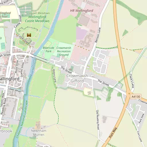
⇅
Location Summary
- Crowmarsh Gifford is located in Oxfordshire
- Administrative Area: Oxfordshire
- Ceremonial County: Oxfordshire
- Historic County: Oxfordshire
- Region & Country: South East / England
⇅
Nearby Towns & Cities
- Wallingford 805 m WNW
- Didcot 9.0 km W
- Watlington 9.1 km NE
- Abingdon-on-Thames 14.0 km NW
- Oxford 19.7 km NNW


⇅
Nearby Localities
- Newnham MurrenDistrict 315 m SE
- WinterbrookDistrict 1.3 km SW
- MongewellVillage 1.5 km SSW
- Preston CrowmarshVillage 2.2 km N
- BensonVillage 2.5 km N
- Slade EndDistrict 2.8 km WNW
- North StokeVillage 3.2 km S
- EwelmeVillage 3.7 km NE
- CholseyVillage 3.8 km SW
- Brightwell-cum-SotwellVillage 3.9 km WNW


⇅
Smaller Settlements
- Mackney 3.3 km WNW
- Rokemarsh 3.7 km N
- Hailey 4.5 km SSE
- Overy 5.7 km NW
- Heath End 6.0 km ESE
- Little Wittenham 6.4 km NW
- Brightwell Baldwin 7.0 km NE
- Park Corner 7.8 km E
- Cookley Green 8.1 km E
- Howe Hill 8.6 km ENE


⇅
Beaches
- Cotswold Hills Beach58.9 km W
- Goatee Beach80.6 km SSW
- Weston Point81.1 km SSW
⇅
Parks
- Loop Meadow9.0 km W
- Merton Field19.3 km NNW
- North Croft26.6 km SW
- The Common16.4 km SE
⇅
Woods
- Marsh Wood1.0 km NE
- Oakley Little Wood2.9 km ESE
- Oakley Wood3.0 km E
- Sand Elms2.4 km NW
⇅
Hills
- Coblers Hill3.3 km SSE
- Rabbits Hill3.4 km NE
- Shillingford Hill3.5 km NNW
- Wicks Hill2.8 km SE
⇅
Lakes
- King's Pond3.7 km NE
- Leyend Pond4.4 km SSE
- Mill Stream1.8 km N
- The Lake1.4 km SSW
⇅
Waterfalls
- Neptune Waterfall39.4 km ENE
- The Cascade48.1 km N
- Tower Waterfall38.9 km ENE
⇅
Headlands
- Botany Bay Point41.4 km ESE
- Tripcock Ness83.9 km E
⇅
Islands
- Lock Wood Island11.6 km NW
- The Island12.2 km NNE

⇅
Wetlands
- Wargrave Marsh19.1 km ESE
- Midgham Marsh23.6 km SSW
- Thatcham Reed Beds25.0 km SSW
⇅
Health Services
- Wallingford Community HospitalHospital 1.1 km WSW
- Joyce GroveHospital 8.9 km ESE
- Benson HouseMedical 2.5 km N
- Rush CourtMedical 2.6 km NNW

⇅
Education
- Crowmarsh Gifford Church of England Primary SchoolSchool 291 m SE
- Wallingford SchoolSchool 1.1 km NW
- Henley Business School University of ReadingUniversity 16.1 km ESE
⇅
Railway Stations
- Wallingford1.5 km W
- Cholsey4.4 km SW
⇅
Bus Stations
- High Wycombe Bus Station24.9 km E
- Aylesbury Bus Station31.7 km NE
⇅
Coach Stations
- High Wycombe Coachway24.2 km E
- Milton Keynes Coachway58.2 km NNE
⇅
Ferry Terminals
- Hampton Ferry Boathouse55.9 km ESE
- Hammerton's Pier57.9 km ESE
⇅
Airports
- Wycombe Air Park21.2 km E
- London Oxford Airport30.1 km NNW
⇅
Airfields
- RAF Benson2.4 km NE
- Chalgrove Airfield8.9 km NNE
⇅
Heliports
- The London Heliport66.2 km ESE
- Magpas Air Ambulance104.9 km NE
⇅
Harbours
- Chelsea Harbour65.9 km ESE
- Ocean Dock81.1 km SSW