
Culmstock
About Culmstock
Culmstock lies within Devon. Neighbouring places include Ashill only 2.9 km South South West, Yondercott just 2.9 km West South West, Uffculme around 3.6 km West South West, Hemyock around 3.6 km East and Millhayes only 3.8 km East. Other countryside places nearby include Hillmoor, Woodgate, Prescott and Northcott.
You may find extra local information by clicking a nearby place.
This information is based on OS, ONS and OSM data released under open licence.
⇅
Local Map
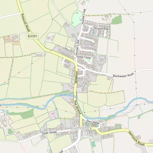
⇅
Location Summary
- Culmstock is located in Devon
- Administrative Area: Devon
- Ceremonial County: Devon
- Historic County: Devon
- Region & Country: South West / England
⇅
Nearby Towns & Cities
- Wellington 7.7 km NNE
- Cullompton 10.5 km SW
- Wiveliscombe 14.1 km N
- Honiton 14.6 km SSE
- Exeter 28.0 km SW


⇅
Nearby Localities
- AshillVillage 2.9 km SSW
- YondercottVillage 2.9 km WSW
- UffculmeVillage 3.6 km WSW
- HemyockVillage 3.6 km E
- MillhayesVillage 3.8 km E
- Great FossendVillage 4.3 km NW
- White BallVillage 5.0 km N
- Sampford ArundelVillage 5.0 km N
- BlackboroughVillage 5.1 km S
- WestleighVillage 5.3 km NW


⇅
Smaller Settlements
- Hillmoor 708 m SE
- Woodgate 1.3 km N
- Prescott 1.4 km WNW
- Northcott 1.4 km SSW
- Nicholashayne 2.2 km N
- Craddock 2.2 km SW
- Old Beat 2.4 km NW
- Gipsy Town 2.4 km NW
- Culm Davy 2.6 km ENE
- Appledore 3.4 km W


⇅
Beaches
- Branscombe Ebb27.4 km SSE
- Jacob's Ladder27.3 km S
- Sidmouth Town Beach26.9 km S
⇅
Parks
- Pennsylvania Park26.2 km SW
- Pleasure Grounds54.3 km WSW
- The Lawn39.7 km SSW
- Yargrass Green53.9 km NE

⇅
Woods
- Alder Grove2.6 km NNW
- Culm Davy Plantation2.2 km NE
- Hillmoor Common1.1 km ESE
- Lincombe Copse2.5 km N


⇅
Hills
- Culm Davy Hill2.8 km NE
- Culmstock Beacon1.5 km NE
- Hackpen Hill2.0 km SSE
- Sampford Point3.3 km NNE
⇅
Lakes
- Mill Pond5.5 km WSW
- Mill Race5.2 km WSW
- Mill Stream4.1 km WSW
- The Basins7.5 km NNE
⇅
Waterfalls
- Becka Falls47.9 km SW
- Broad Falls64.8 km SW
- Horseshoe Falls58.3 km SW
⇅
Headlands
- Blue Ben30.1 km N
- Brandy Head30.7 km S
⇅
Islands
- Fenning Island37.7 km NNE
- Stert Island39.6 km NNE
⇅
Wetlands
- New Marsh20.4 km N
- Farway Marsh22.1 km ESE
- Stafford Marsh26.6 km SE
⇅
Health Services
- Wellington Community HospitalHospital 7.5 km NNE
- Castle Place PracticeHospital 15.0 km W
- Oaktree CourtMedical 6.9 km NE
- Chelston Park Nursing HomeMedical 8.0 km NE
⇅
Education
- Culmstock Primary SchoolSchool 289 m NNW
- Uffculme Primary SchoolSchool 3.3 km WSW
- Exeter AcademyUniversity 26.1 km SW
⇅
Railway Stations
- Tiverton Parkway5.6 km W
- Feniton14.6 km S
⇅
Bus Stations
- Taunton Bus Station16.3 km NE
- Exeter Bus Station27.3 km SW
⇅
Coach Stations
- Torquay Coach Station52.5 km SSW
- Plymouth Coach Station85.9 km SW
⇅
Ferry Terminals
- Starcross Pier34.4 km SSW
- Greenway Quay63.4 km SSW
⇅
Airports
- Exeter Airport22.3 km SSW
- Cardiff Airport53.7 km N
⇅
Airfields
- Dunkeswell Airfield6.9 km SSE
- Watchford Farm12.9 km E
⇅
Heliports
- Cardiff City Heliport62.0 km N
- Lake Heliport69.2 km W
⇅
Harbours
- Watchet Harbour29.7 km N
- Lympstone Boat Shelter31.8 km SSW