
Deeping St James
About Deeping St James
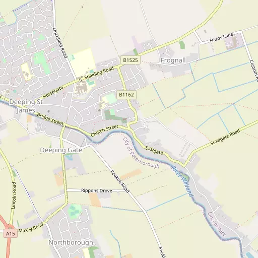
Deeping St James, in Lincolnshire, has Deeping Gate lying 776 m West, Frognall only 1.3 km North East, Northborough lying 1.6 km South South West and Peakirk around 3.3 km South South East. Other countryside settlements include Lolham, Ashton, Obthorpe, Upton and Newstead.
You may find extra local information by clicking a nearby place.
The place data here is drawn from OS, ONS and OSM under open licence.
⇅
Local Map
⇅
Location Summary
- Deeping St James is located in Lincolnshire
- Administrative Area: Lincolnshire
- Ceremonial County: Lincolnshire
- Historic County: Lincolnshire
- Region & Country: East Midlands / England
⇅
Nearby Towns & Cities
- Market Deeping 2.0 km WNW
- Crowland 8.1 km E
- Bourne 12.4 km NNW
- Stamford 13.1 km W
- Peterborough 11.4 km SSE


⇅
Nearby Localities
- Deeping Gate Village 776 m W
- FrognallVillage 1.3 km NE
- Northborough Village 1.6 km SSW
- Peakirk Village 3.3 km SSE
- Glinton Village 3.6 km S
- Maxey Village 3.6 km WSW
- Etton Village 3.6 km SSW
- LangtoftVillage 4.6 km NW
- Milking Nook Village 4.6 km SSE
- West DeepingVillage 4.8 km W


⇅
Smaller Settlements

⇅
Beaches
- Snettisham Beach53.9 km ENE
- Snettisham Scalp54.0 km ENE
- Stubborn Sand56.2 km ENE

⇅
Parks
- Buckwell Green49.4 km SW
- Larks Green5.5 km S
- New Pasture37.5 km S
- Wilsford Warren36.3 km NNW

⇅
Woods
- Fox Covert4.5 km S
- Marsh Plantation6.5 km WNW
- Rice Wood6.0 km SW
- Steeping Wood5.9 km SSW
⇅
Hills
- Box Hill10.9 km WSW
- Love's Hill11.5 km SSW
- Mill Hill12.4 km SSW
- Temple Hill11.0 km S
⇅
Lakes
- Oldfield Pond9.6 km SSW
- The Lake7.5 km E
- Thorpe Watering10.3 km S
- Werrington Lakes4.2 km SSE
⇅
Waterfalls
- Neptune Waterfall111.9 km S
- The Cascade86.9 km SW
- Tower Waterfall111.7 km S
⇅
Headlands
- North Weir Point137.9 km ESE
- Tripcock Ness131.8 km SSE

⇅
Islands
- Brown's Island27.3 km W
- Park Island2.2 km SE

⇅
Wetlands
- Horse Marsh5.5 km W
- West Marsh7.5 km WSW
- Pinchbeck Marsh21.4 km NNE

⇅
Health Services
- Orthopaedic and Spine Specialist HospitalHospital 7.3 km S
- Peterborough City HospitalHospital 9.6 km S
- Braeburn LodgeMedical 746 m NNW
- The Astoria ParkMedical 10.1 km SSE
⇅
Education
- Deeping St James Community Primary SchoolSchool 386 m NW
- The Deepings SchoolSchool 908 m NW
- University of LincolnUniversity 24.9 km NE
⇅
Railway Stations
- Peterborough11.1 km SSE
- Peterborough Nene Valley11.8 km SSE
⇅
Bus Stations
- Bourne Bus Station12.6 km NNW
- Spalding Bus Station16.1 km NE
⇅
Coach Stations
- Milton Keynes Coachway73.9 km SSW
- Luton Airport Bus and Coach Station88.2 km S
⇅
Ferry Terminals
- Normanton Chain Ferry65.1 km WNW
- Hull Ferry Port119.3 km N
⇅
Airports
- Nottingham City Airport60.0 km WNW
- Cambridge City Airport60.8 km SSE
⇅
Airfields
- Crowland Airfield11.1 km ENE
- Sibson Aerodrome14.4 km SSW
⇅
Heliports
- Magpas Air Ambulance32.7 km S
- Nottingham Heliport53.4 km WNW
⇅
Harbours
- Farndon Harbour57.7 km NW
- Brancaster Harbour72.4 km ENE