
Fort End, Haddenham (Buckinghamshire)
About Fort End
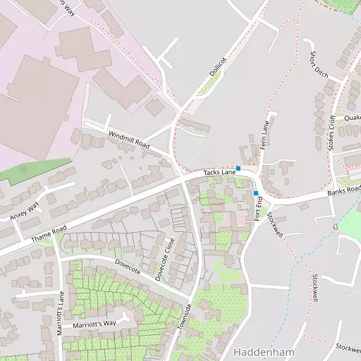
Fort End is positioned 353 m S from Haddenham (Buckinghamshire) in Buckinghamshire. Places nearby include Haddenham situated 353 m South, Diggs around 700 m South South West, Townsend lying 765 m North East, Church End only 769 m South South East and Kingsey only 2.1 km South. Other settlements in the area include Aston Sandford, Gibraltar, Ilmer and Easington.
You may find out something new or interesting if you click a nearby place to see more local information.
The place data here is drawn from OS, ONS and OSM under open licence.
⇅
Local Map
⇅
Location Summary
- Fort End is a neighbourhood in Haddenham (Buckinghamshire)
- Administrative Area: Buckinghamshire
- Ceremonial County: Buckinghamshire
- Historic County: Buckinghamshire
- Region & Country: South East / England
⇅
Nearby Towns & Cities
- Parent town: Haddenham (Buckinghamshire)
- Thame 4.4 km SW
- Princes Risborough 8.7 km SE
- Aylesbury 9.5 km ENE
- Wendover 12.9 km E
- Oxford 22.7 km W


⇅
Nearby Localities
- HaddenhamVillage 353 m S
- DiggsDistrict 700 m SSW
- TownsendDistrict 765 m NE
- Church EndDistrict 769 m SSE
- KingseyVillage 2.1 km S
- CuddingtonVillage 2.2 km N
- ChearsleyVillage 2.9 km NW
- DintonVillage 3.1 km NE
- Nether WinchendonVillage 3.4 km N
- TowerseyVillage 3.7 km S


⇅
Smaller Settlements
- Aston Sandford 2.1 km ESE
- Gibraltar 2.8 km NE
- Ilmer 4.5 km SE
- Easington 5.3 km WNW
- Lower Pollicott 5.6 km NW
- Owlswick 5.7 km ESE
- Forty Green 5.8 km SSE
- Upper Pollicott 6.0 km NW
- Holly Green 6.3 km SSE
- Kimble Wick 6.4 km E


⇅
Beaches
- Cotswold Hills Beach72.1 km W
- Goatee Beach103.2 km SSW
- Weston Point103.2 km SSW
⇅
Parks
- Chaulden Meadow29.7 km E
- Elfield Park29.6 km NNE
- Loop Meadow27.9 km SW
- Merton Field22.2 km W

⇅
Woods
- Bettymoor Plantation1.4 km NNW
- Hook Covert1.5 km S
- Stonehill Land Plantation1.2 km NNE
- Yolsum Plantation1.4 km WNW

⇅
Hills
- Burn Hill5.8 km NE
- Cop Hill3.8 km W
- Dadbrook Hill1.6 km N
- Waddesdon Hill6.8 km NNE
⇅
Lakes
- Banks Pond298 m E
- Lenton's Pond2.6 km WNW
- Rudd's Pond658 m NE
- Tack's Pond360 m ENE
⇅
Waterfalls
- Neptune Waterfall27.9 km ESE
- The Cascade28.8 km NNW
- Tower Waterfall27.1 km ESE
⇅
Headlands
- Botany Bay Point46.4 km SSE
- Tripcock Ness76.4 km ESE
⇅
Islands
- China Island9.6 km NW
- Grotto Island9.8 km NW
⇅
Wetlands
- Cock Marsh26.4 km SSE
- Wargrave Marsh29.1 km S
- Ranger's Marsh41.4 km WNW
⇅
Health Services
- Thame Community HospitalHospital 4.2 km SW
- Stoke Mandeville HospitalHospital 9.3 km ENE
- Meadowcroft Care HomeMedical 3.8 km SW
- Stone HouseMedical 5.7 km ENE
⇅
Education
- Haddenham County First SchoolSchool 409 m E
- Haddenham Junior SchoolSchool 575 m E
- Buckinghamshire New UniversityUniversity 9.5 km ENE
⇅
Railway Stations
- Haddenham and Thame Parkway952 m WSW
- Bledlow Bridge Halt7.4 km SSE

⇅
Bus Stations
- Aylesbury Bus Station9.3 km ENE
- High Wycombe Bus Station19.8 km SE
⇅
Coach Stations
- High Wycombe Coachway21.1 km SSE
- Milton Keynes Coachway35.1 km NNE
⇅
Ferry Terminals
- Hammerton's Pier55.9 km SE
- Hampton Ferry Boathouse56.1 km SE
⇅
Airports
- Wycombe Air Park20.1 km SSE
- London Oxford Airport27.7 km WNW
⇅
Airfields
- Halton Airfield13.4 km E
- Chalgrove Airfield15.2 km SW
⇅
Heliports
- The London Heliport61.9 km ESE
- Magpas Air Ambulance81.7 km NE
⇅
Harbours
- Chelsea Harbour61.4 km ESE
- Ocean Dock103.3 km SSW