
Gamlingay
About Gamlingay
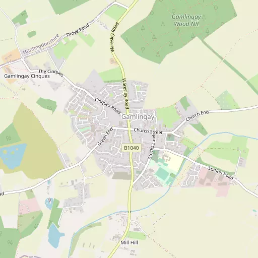
Gamlingay is in Cambridgeshire. Places nearby include Green End around 362 m North West, Dennis Green only 606 m South West, Dutter End lying 613 m East, Little Heath situated 658 m South West and Gamlingay Cinques situated 1.2 km West North West. Other countryside places nearby include Tetworth, Woodbury, Cockayne Hatley and Snow Hill.
You might discover something new by clicking a nearby place for more local details.
This information is based on OS, ONS and OSM data released under open licence.
⇅
Local Map
⇅
Location Summary
- Gamlingay is located in Cambridgeshire
- Administrative Area: Cambridgeshire
- Ceremonial County: Cambridgeshire
- Historic County: Cambridgeshire
- Region & Country: Eastern / England
⇅
Nearby Towns & Cities
⇅
Nearby Localities
⇅
Smaller Settlements
⇅
Beaches
- Hadleigh Ray
- Mill Beach
- West Mersea Beach
⇅
Parks
- Empty Common
- New Pasture
- Reed Green
- Wimpole Park
⇅
Woods
- Gamlingay Heath Plantation
- Gamlingay Wood
- Park Plantations
- Sand Wood
⇅
Hills
- Bullby Hill
- Peg Nut Hill
- Summerhouse Hill
- Warden Hill
⇅
Lakes
- Latch Pool
- Mill Dole Pond
- Storey Moats
- White Gate Pond
⇅
Waterfalls
- Neptune Waterfall
- The Cascade
- Tower Waterfall
⇅
Headlands
- Botany Bay Point
- Tripcock Ness
⇅
Islands
- Longholme Island
- The Island
⇅
Wetlands
- Fowlmere
- Ouse Fen
- Chesterton Fen
⇅
Health Services
- Biggleswade Hospital
- Kneesworth House Hospital
- Potton House
- Eltisley Manor
⇅
Education
- Gamlingay First School
- Village College
- Polhill Campus
⇅
Railway Stations
- Sandy
- Biggleswade
⇅
Bus Stations
- Royston Bus Station
- Huntingdon Bus Station
⇅
Coach Stations
- Luton Airport Bus and Coach Station
- Milton Keynes Coachway
⇅
Ferry Terminals
- Blackfriars Pier
- Bankside Pier
⇅
Airports
- Cambridge City Airport
- London Luton Airport
⇅
Airfields
- Little Grandsden Airfield
- Top Farm Airfield
⇅
Heliports
- Magpas Air Ambulance
- The Egerton-Smith Centre
⇅
Harbours
- Chelsea Harbour
- Harwich Harbour