
Geddington
About Geddington
Geddington sits within North Northamptonshire. Nearby places include Weekley around 2.2 km South South West, Warkton around 2.9 km South, Grafton Underwood lying 3.9 km South East, Great Oakley around 4.2 km North West and Stanion only 4.6 km North North East. Other countryside places nearby include Newton, Little Oakley, Pipewell and Orton.
You might learn something new by clicking through to a nearby place.
All information is drawn from OS, ONS and OSM under open licence, reflecting the best available public data.
⇅
Local Map
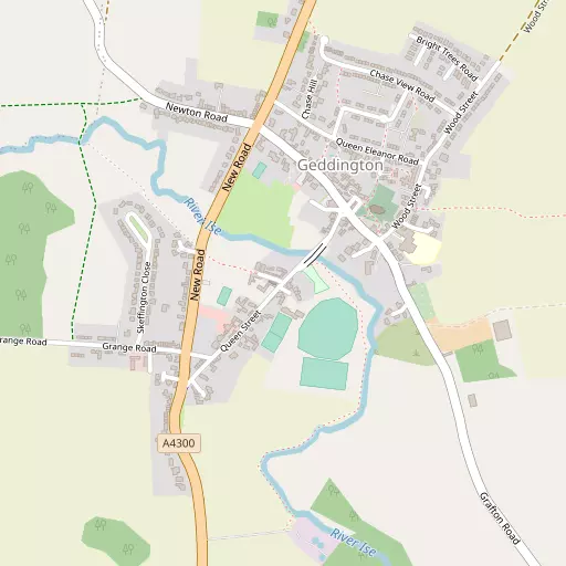
⇅
Location Summary
- Geddington is located in North Northamptonshire
- Administrative Area: North Northamptonshire
- Ceremonial County: North Northamptonshire
- Historic County: North Northamptonshire
- Region & Country: East Midlands / England
⇅
Nearby Towns & Cities
- Kettering 4.9 km SW
- Corby 5.8 km N
- Burton Latimer 8.2 km S
- Desborough 9.1 km W
- Peterborough 33.7 km ENE


⇅
Nearby Localities
- WeekleyVillage 2.2 km SSW
- WarktonVillage 2.9 km S
- Grafton UnderwoodVillage 3.9 km SE
- Great OakleyDistrict 4.2 km NW
- StanionVillage 4.6 km NNE
- WadcroftDistrict 5.0 km SW
- RushtonVillage 5.1 km W
- BrigstockVillage 5.8 km ENE
- Barton SeagraveDistrict 6.0 km S
- Corby Old VillageDistrict 6.1 km N


⇅
Smaller Settlements
- Newton 1.3 km WNW
- Little Oakley 2.8 km N
- Pipewell 6.0 km WNW
- Orton 9.3 km WSW
- Thorpe Underwood 10.6 km W
- Bringhurst 10.7 km NNW
- Hill Top 10.8 km S
- Brampton Ash 11.2 km WNW
- Foxhall 12.2 km WSW
- Pilton 12.9 km E


⇅
Beaches
- Snettisham Beach90.0 km ENE
- Snettisham Scalp90.3 km ENE
- Stubborn Sand92.8 km NE

⇅
Parks
- Buckwell Green14.7 km S
- Foot Meadow26.8 km SW
- Larks Green34.2 km NE
- The Green30.5 km SW
⇅
Woods
- Bright Trees1.5 km ENE
- Lardours Wood1.3 km NNE
- New Ground Spinney886 m S
- Square Spinney1.4 km WSW
⇅
Hills
- Harborough Hill12.1 km N
- Winning Foot Hill10.8 km ENE
- Woodford Hill7.9 km SE
- Yoke Hill8.9 km NE
⇅
Lakes
- Cransley Reservoir8.0 km SW
- Star Pond1.9 km S
- Thorpe Malsor Reservoir7.6 km WSW
- Willow Brook (North)8.8 km NNE
⇅
Waterfalls
- Neptune Waterfall84.9 km S
- The Cascade50.7 km SSW
- Tower Waterfall84.4 km S
⇅
Headlands
- Botany Bay Point114.1 km S
- Tripcock Ness116.1 km SSE

⇅
Islands
- Brown's Island24.2 km N
- Pinchmill Islands26.1 km SSE
⇅
Wetlands
- Summer Leys19.2 km S
- West Marsh31.3 km NE
- Lucas Marsh31.9 km WNW
⇅
Health Services
- Glendon Wood HospitalHospital 3.3 km WSW
- St Mary's HospitalHospital 5.2 km SSW
- Weekley Rise Nursing HomeMedical 2.6 km SSW
- Olive Row Care HomeMedical 4.6 km SSW
⇅
Education
- Geddington Church of England Primary SchoolSchool 320 m ENE
- Brambleside Community Primary SchoolSchool 3.0 km SW
- Tresham College of Further and Higher EducationUniversity 5.6 km SSW
⇅
Railway Stations
- Kettering5.7 km SSW
- Corby5.8 km N
⇅
Bus Stations
- Oakham Bus Station26.1 km N
- North Gate Bus Station26.2 km SSW
⇅
Coach Stations
- Milton Keynes Coachway42.4 km S
- Luton Airport Bus and Coach Station65.5 km SSE
⇅
Ferry Terminals
- Normanton Chain Ferry54.7 km NW
- Embankment Pier110.4 km SSE
⇅
Airports
- Coventry Airport54.4 km W
- Nottingham City Airport60.0 km NNW
⇅
Airfields
- Deenethorpe Airfield9.9 km NE
- Spanhoe Airfield14.3 km NNE
⇅
Heliports
- Magpas Air Ambulance30.4 km ESE
- Nottingham Heliport50.4 km NNW

⇅
Harbours
- Farndon Harbour70.6 km N
- Brancaster Harbour109.0 km NE