
Gosberton
About Gosberton
Gosberton, in Lincolnshire, has Westhorpe around 2.2 km West, Quadring lying 2.2 km North West, Risegate around 3.5 km West South West and Surfleet around 3.6 km South South East. Other rural localities include Wargate, Quadring Eaudike, Church End, Gosberton Cheal and Burtoft.
You might learn something new by clicking through to a nearby place.
These details are compiled from OS, ONS and OSM data released under open licence.
⇅
Local Map
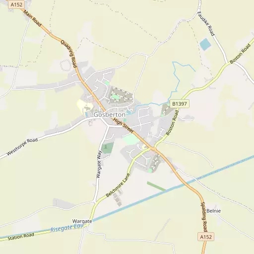
⇅
Location Summary
- Gosberton is located in Lincolnshire
- Administrative Area: Lincolnshire
- Ceremonial County: Lincolnshire
- Historic County: Lincolnshire
- Region & Country: East Midlands / England
⇅
Nearby Towns & Cities
- Spalding 9.0 km S
- Boston 14.9 km NE
- Heckington 15.7 km NW
- Bourne 18.4 km SW
- Peterborough 33.3 km S


⇅
Nearby Localities
- WesthorpeVillage 2.2 km W
- QuadringVillage 2.2 km NW
- RisegateVillage 3.5 km WSW
- SurfleetVillage 3.6 km SSE
- Surfleet Seas EndVillage 3.7 km SE
- Sutterton DowdykeVillage 4.5 km ENE
- CrossgateDistrict 4.9 km S
- Fen EndDistrict 5.0 km NW
- WigtoftVillage 5.1 km NNE
- DoningtonVillage 5.2 km NW


⇅
Smaller Settlements
- Wargate 1.2 km SSW
- Quadring Eaudike 2.1 km NNW
- Church End 2.9 km NNW
- Gosberton Cheal 3.8 km SW
- Burtoft 4.4 km NE
- Donington South Ing 4.8 km NW
- Hoffleet Stow 5.3 km N
- Wykeham 6.0 km SSE
- Asperton 6.5 km NNE
- Bicker Bar 7.0 km N


⇅
Beaches
- Snettisham Beach40.6 km E
- Snettisham Scalp40.1 km E
- Stubborn Sand41.4 km E

⇅
Parks
- Burgage Green58.0 km WNW
- Larks Green28.7 km SSW
- New Pasture59.0 km S
- Wilsford Warren24.1 km WNW

⇅
Woods
- Bullbank Holt6.0 km NW
- Cricket Bat Willows4.0 km S
- Oak Holt4.1 km SSW
- Pinchbeck Wood6.0 km SSW
⇅
Hills
- Beacon Hill14.7 km W
- Festival Hill8.1 km SSE
- Neatfold Hill15.8 km WNW
- Stow Green Hill14.7 km WNW
⇅
Lakes
- Coronation Channel10.2 km S
- Fountain Pool8.1 km SSE
- Kestral Lake12.0 km NE
- Westhorpe Pit2.0 km WSW
⇅
Waterfalls
- Kinder Downfall128.9 km WNW
- The Cascade110.1 km SSW
- Tower Waterfall134.9 km SSW
⇅
Headlands
- Flamborough Head138.9 km N
- North Weir Point143.0 km SE
⇅
Islands
- Outer Trial Bank27.1 km E
- Park Island24.7 km SSW
⇅
Wetlands
- Rush Marsh1.2 km NE
- Gosberton Marsh2.7 km E
- Sutterton Marsh4.0 km E
⇅
Health Services
- Johnson Community HospitalHospital 7.4 km S
- Old Johnson HospitalHospital 9.2 km S
- Gosberton HouseMedical 405 m WNW
- Cedar FallsMedical 10.3 km S
⇅
Education
- Gosberton Primary SchoolSchool 292 m SE
- Gosberton House AcademySchool 485 m WNW
- University of LincolnUniversity 12.3 km ESE

⇅
Railway Stations
- Spalding8.8 km S
- Swineshead11.5 km N
⇅
Bus Stations
- Spalding Bus Station8.7 km S
- Bourne Bus Station18.2 km SW
⇅
Coach Stations
- Chesterfield Coach Station94.2 km WNW
- Milton Keynes Coachway97.5 km SSW
⇅
Ferry Terminals
- Normanton Chain Ferry72.5 km W
- Hull Ferry Port97.7 km N
⇅
Airports
- Wickenby Aerodrome51.6 km NNW
- Nottingham City Airport62.1 km W
⇅
Airfields
- Boston Aerodrome13.1 km NNE
- Fenland Airfield16.9 km SSE
⇅
Heliports
- Lincs and Notts Air Ambulance HQ41.1 km NW
- Magpas Air Ambulance54.8 km S
⇅
Harbours
- Farndon Harbour51.2 km WNW
- Brancaster Harbour56.2 km ENE