
Green End
About Green End
Green End lies within Bedford. Nearby places include Pertenhall only 462 m North East, Wood End situated 1.6 km North East, Keysoe around 1.7 km South South West and Swineshead lying 2.5 km West North West. Other rural localities include West End, Lower Dean, Wood End, Dillington and Backnoe End.
You may notice something interesting if you explore one of the nearby places.
Data shown here comes from OS, ONS and OSM under open licence, using the latest public sources available.
⇅
Local Map
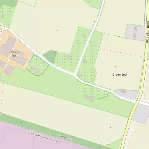
⇅
Location Summary
⇅
Nearby Towns & Cities
- St Neots 11.2 km ESE
- Raunds 11.5 km NW
- Rushden 12.5 km W
- Higham Ferrers 12.6 km WNW
- Milton Keynes 34.2 km SW


⇅
Nearby Localities
- PertenhallVillage 462 m NE
- Wood EndDistrict 1.6 km NE
- KeysoeVillage 1.7 km SSW
- SwinesheadVillage 2.5 km WNW
- Little StaughtonVillage 3.4 km SE
- KimboltonVillage 3.5 km NNE
- StonelyVillage 3.6 km NE
- Keysoe RowVillage 3.7 km SSW
- NewtownDistrict 3.8 km NNE
- TilbrookVillage 4.1 km N


⇅
Smaller Settlements
- West End 3.0 km SE
- Lower Dean 4.9 km NNW
- Wood End 5.0 km SSE
- Dillington 5.4 km E
- Backnoe End 5.5 km SSW
- Shelton 6.2 km NW
- Cross End 6.7 km SSW
- Bourne End 7.5 km WSW
- Rootham's Green 7.7 km SSE
- North End 7.7 km SW


⇅
Other places with this name
Closest
- Green End, Bedford2.7 km SE
- Green End, Bedford13.0 km SSE
- Green End, Cambridgeshire17.0 km ENE
- Green End, Bedford19.0 km SSW
- Green End, Cambridgeshire19.6 km SE

Furthest away
- Green End, North Yorkshire 239.6 km N
- Green End, Lancashire 215.6 km NNW
- Green End 202.4 km NNW
- Green End, Warwickshire 85.0 km WNW
- Green End, Buckinghamshire74.6 km SSW
⇅
Beaches
- Snettisham Beach88.0 km NE
- Snettisham Scalp88.7 km NE
- Stubborn Sand91.5 km NE
⇅
Parks
- Buckwell Green19.7 km W
- New Pasture16.3 km ENE
- The Green32.3 km SW
- Wimpole Park28.6 km ESE
⇅
Woods
- Galley Oak Spinney538 m SW
- Mountwood Spinney2.1 km NNE
- Poplar Spinney1.7 km W
- Sowmead's Spinney1.1 km WSW
⇅
Hills
- Agden Hill5.0 km ENE
- Hungry Hill2.1 km N
- Town Hill3.8 km NE
- Warren Hill4.5 km NE
⇅
Lakes
- Cesspools6.3 km NNW
- Dragonfly Pond5.7 km ENE
- Seabrook Lake6.5 km SSE
- Tom Knocker's Pond6.5 km SW
⇅
Waterfalls
- Neptune Waterfall66.7 km S
- The Cascade49.0 km WSW
- Tower Waterfall66.4 km S

⇅
Headlands
- Botany Bay Point96.4 km S
- Tripcock Ness91.7 km SSE
⇅
Islands
- Perch Islands11.7 km SW
- Pinchmill Islands10.3 km SW
⇅
Wetlands
- Summer Leys19.5 km W
- Ouse Fen30.5 km ENE
- Fowlmere37.9 km ESE
⇅
Health Services
- Hinchingbrooke HospitalHospital 16.2 km ENE
- Manor HospitalHospital 16.2 km SSW
- Avenue House Nursing HomeMedical 9.9 km W
- Nelson LodgeMedical 10.5 km SE
⇅
Education
- Kimbolton SchoolSchool 3.3 km NE
- Kimbolton School Preparatory DepartmentSchool 3.5 km NNE
- Polhill CampusUniversity 14.4 km S
⇅
Railway Stations
- St Neots12.3 km ESE
- Bedford15.5 km SSW
⇅
Bus Stations
- Huntingdon Bus Station17.1 km ENE
- North Gate Bus Station33.0 km W
⇅
Coach Stations
- Milton Keynes Coachway30.7 km SW
- Luton Airport Bus and Coach Station43.7 km S
⇅
Ferry Terminals
- Normanton Chain Ferry80.6 km NW
- Blackfriars Pier87.3 km SSE
⇅
Airports
- Cambridge City Airport41.1 km E
- London Luton Airport44.0 km S
⇅
Airfields
- Sackfield Airfield4.7 km WSW
- RAF Alconbury17.1 km NE
⇅
Heliports
- Magpas Air Ambulance16.5 km NE
- The Egerton-Smith Centre40.7 km E
⇅
Harbours
- Chelsea Harbour90.0 km S
- Farndon Harbour92.8 km NNW