
Haconby
About Haconby
Haconby, in Lincolnshire, has Dunsby only 1.4 km North, Morton lying 1.6 km South South West, Rippingale only 2.5 km North North West, Hanthorpe lying 2.5 km South West and Dyke only 2.9 km South. Other rural settlements include Stainfield, Cawthorpe, Graby and Elsthorpe.
You may find out something new or interesting if you click a nearby place to see more local information.
The place data here is drawn from OS, ONS and OSM under open licence.
⇅
Local Map
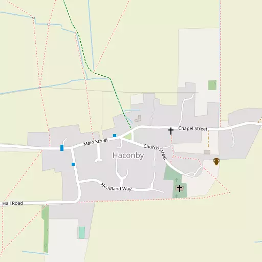
⇅
Location Summary
- Haconby is located in Lincolnshire
- Administrative Area: Lincolnshire
- Ceremonial County: Lincolnshire
- Historic County: Lincolnshire
- Region & Country: East Midlands / England
⇅
Nearby Towns & Cities
- Bourne 5.3 km SSW
- Spalding 14.5 km ESE
- Market Deeping 15.8 km S
- Heckington 18.8 km NNE
- Peterborough 28.2 km SSE


⇅
Nearby Localities
- DunsbyVillage 1.4 km N
- MortonVillage 1.6 km SSW
- RippingaleVillage 2.5 km NNW
- HanthorpeVillage 2.5 km SW
- DykeVillage 2.9 km S
- Kirkby UnderwoodVillage 3.5 km WNW
- DowsbyVillage 4.2 km NNE
- AslackbyVillage 5.3 km NNW
- EdenhamVillage 5.4 km SW
- GrimsthorpeVillage 6.0 km WSW


⇅
Smaller Settlements
- Stainfield 2.5 km W
- Cawthorpe 3.6 km SSW
- Graby 4.3 km N
- Elsthorpe 4.9 km WSW
- Bulby 5.2 km W
- Millthorpe 5.6 km N
- Hawthorpe 6.3 km WNW
- Twenty 6.8 km SE
- Laughton 6.8 km NNW
- Scottlethorpe 7.0 km SW


⇅
Beaches
- Snettisham Beach54.5 km E
- Snettisham Scalp54.2 km E
- Stubborn Sand55.7 km E

⇅
Parks
- Burgage Green49.2 km NW
- Larks Green22.2 km SSE
- New Pasture54.1 km SSE
- Wilsford Warren19.5 km NNW

⇅
Woods
- Dunsby Spinney1.0 km W
- Dunsby Wood1.7 km WNW
- Hacconby Spinney1.2 km WSW
- Ringstone Wood2.5 km WNW
⇅
Hills
- Beacon Hill7.5 km N
- Galley Hill5.6 km WSW
- Maize Hill7.2 km WSW
- Mill Hill8.2 km WSW
⇅
Lakes
- Mill Pond13.4 km SW
- St Peter's Pool5.6 km SSW
- Stew Pond8.1 km WSW
- Westhorpe Pit12.9 km ENE

⇅
Waterfalls
- Kinder Downfall120.1 km WNW
- The Cascade98.2 km SSW
- Tower Waterfall126.9 km S
⇅
Headlands
- Flamborough Head145.8 km N
- Tripcock Ness148.5 km SSE
⇅
Islands
- Brown's Island28.6 km SW
- Park Island18.9 km SSE
⇅
Wetlands
- Rush Marsh16.0 km ENE
- Hill Marsh16.6 km E
- Pinchbeck Marsh16.7 km E
⇅
Health Services
- Johnson Community HospitalHospital 14.2 km E
- Old Johnson HospitalHospital 14.4 km ESE
- The CedarsMedical 5.4 km S
- Wood GrangeMedical 5.4 km SSW
⇅
Education
- Morton Church of England (Controlled) Primary SchoolSchool 1.5 km SSW
- Bourne AcademySchool 4.7 km S
- University of EvansvilleUniversity 22.2 km WNW
⇅
Railway Stations
- Spalding14.1 km ESE
- Heckington18.6 km NNE
⇅
Bus Stations
- Bourne Bus Station5.0 km SSW
- Spalding Bus Station14.2 km E
⇅
Coach Stations
- Chesterfield Coach Station85.2 km WNW
- Milton Keynes Coachway87.5 km SSW
⇅
Ferry Terminals
- Normanton Chain Ferry58.5 km W
- Hull Ferry Port103.3 km N
⇅
Airports
- Nottingham City Airport49.7 km WNW
- Wickenby Aerodrome55.8 km N
⇅
Airfields
- Crowland Airfield19.1 km SE
- RAF Barkston Heath21.2 km NW
⇅
Heliports
- Lincs and Notts Air Ambulance HQ40.8 km NNW
- Nottingham Heliport45.1 km W
⇅
Harbours
- Farndon Harbour42.9 km NW
- Brancaster Harbour70.9 km ENE