
Hardington Mandeville
About Hardington Mandeville
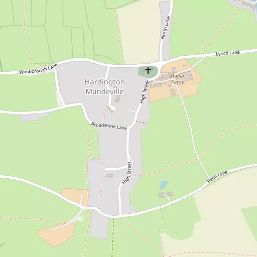
Hardington Mandeville is in Somerset. Neighbouring places include Hardington Moor just 863 m North East, West Coker around 1.9 km North North East, East Chinnock around 2.2 km North West, Holywell just 2.3 km North East and Burton lying 2.8 km North East. Other countryside places nearby include Lyatts, Pendomer, Hardington Marsh and Nash.
You may find extra local information by clicking a nearby place.
This information is based on OS, ONS and OSM data released under open licence.
⇅
Local Map
⇅
Location Summary
- Hardington Mandeville is located in Somerset
- Administrative Area: Somerset
- Ceremonial County: Somerset
- Historic County: Somerset
- Region & Country: South West / England
⇅
Nearby Towns & Cities
- Yeovil 6.1 km NE
- Crewkerne 7.3 km WSW
- South Petherton 9.5 km WNW
- Beaminster 10.8 km SSW
- Wells 34.2 km N


⇅
Nearby Localities
- Hardington MoorVillage 863 m NE
- West CokerVillage 1.9 km NNE
- East ChinnockVillage 2.2 km NW
- HolywellVillage 2.3 km NE
- BurtonVillage 2.8 km NE
- East CokerVillage 3.0 km ENE
- North CokerVillage 3.0 km ENE
- OdcombeVillage 3.8 km N
- Haselbury PlucknettVillage 4.1 km WSW
- North PerrottVillage 4.1 km WSW


⇅
Smaller Settlements
- Lyatts 1.1 km ENE
- Pendomer 1.6 km SE
- Hardington Marsh 2.1 km SSW
- Nash 3.5 km NE
- Sutton Bingham 3.6 km E
- Brympton d'Evercy 3.8 km N
- Netherstoke 4.0 km SE
- Lower Halstock Leigh 4.1 km SSE
- Middle Chinnock 4.1 km WNW
- Higher Halstock Leigh 4.4 km S


⇅
Beaches
- East Beach22.0 km SSW
- Seatown Beach22.0 km SSW
- West Bay Beach21.9 km SSW
⇅
Parks
- Frenches Farm Natural Greenspace49.2 km ESE
- Lower Common58.2 km NNE
- Worle Moor53.0 km NNW
- Yargrass Green34.7 km N


⇅
Woods
- Haygrove Plantation1.6 km ENE
- Moor Plantation1.2 km NE
- Moor's Plantation1.5 km E
- Oatclose Plantation1.3 km ESE
⇅
Hills
- Coker Hill1.6 km N
- Cold Harbour Hill332 m SW
- Kit Hill1.8 km ESE
- Windmill Hill434 m ESE

⇅
Lakes
- Green Pond4.4 km SE
- Pit Pond4.3 km NNW
- Sutton Bingham Reservoir3.8 km ESE
- West Lake2.1 km NNE
⇅
Waterfalls
- Becka Falls81.2 km WSW
- Broad Falls96.6 km WSW
- Horseshoe Falls89.9 km WSW
⇅
Headlands
- Bran Point38.1 km SE
- Stert Point41.8 km NNW
⇅
Islands
- Bathing Island27.1 km E
- Fish's Island26.9 km E
⇅
Wetlands
- Coker Marsh3.4 km E
- Wytherston Marsh13.7 km SSE
- Hope Corner21.7 km SSW
⇅
Health Services
- Summerlands HospitalHospital 5.9 km NE
- Yeovil District HospitalHospital 6.4 km NE
- The Knoll Nursing HomeMedical 6.1 km NE
- The OrchardsMedical 7.1 km WSW
⇅
Education
- West Coker Church of England (Voluntary Controlled) Primary SchoolSchool 1.8 km N
- East Coker Community Primary SchoolSchool 2.9 km ENE
- Architectural Association Hooke ParkUniversity 12.6 km S
⇅
Railway Stations
- Yeovil Junction6.3 km ENE
- Crewkerne6.6 km WSW
⇅
Bus Stations
- Taunton Bus Station31.3 km WNW
- Poole Bus Station54.4 km ESE
⇅
Coach Stations
- Millstream Coach Park65.6 km ENE
- Torquay Coach Station76.0 km SW
⇅
Ferry Terminals
- Brownsea Island Ferry54.2 km ESE
- Sandbanks57.9 km ESE
⇅
Airports
- Bristol Airport53.4 km N
- Exeter Airport53.7 km WSW
⇅
Airfields
- Yeovil Westland Airfield4.8 km NE
- Royal Naval Air Station Yeovilton12.4 km NNE
⇅
Heliports
- Cardiff City Heliport70.0 km NNW
- Lake Heliport109.9 km W

⇅
Harbours
- Bridport Harbour21.9 km SSW
- Portland Harbour39.6 km SSE