
Husborne Crawley
About Husborne Crawley
Husborne Crawley, in Central Bedfordshire, has Church End just 145 m East, Aspley Guise only 1.2 km West South West, Ridgmont just 2.1 km East, Brogborough lying 2.3 km North North East and Aspley Heath just 3.1 km West South West. Other rural places nearby include Birchmoor Green, Hulcote, Lower End and Speedwell.
You may find extra local information by clicking a nearby place.
The details shown here use OS, ONS and OSM data provided under open licence.
⇅
Local Map
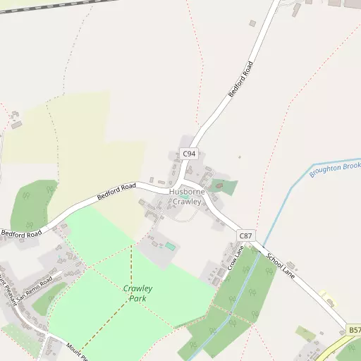
⇅
Location Summary
- Husborne Crawley is located in Central Bedfordshire
- Administrative Area: Central Bedfordshire
- Ceremonial County: Bedfordshire
- Historic County: Central Bedfordshire
- Region & Country: Eastern / England
⇅
Nearby Towns & Cities


⇅
Nearby Localities
- Church EndDistrict 145 m E
- Aspley GuiseVillage 1.2 km WSW
- RidgmontVillage 2.1 km E
- BrogboroughVillage 2.3 km NNE
- Aspley HeathVillage 3.1 km WSW
- Eagle Farm South District 3.5 km NW
- SalfordVillage 3.6 km NNW
- Wavendon Village 4.2 km WNW
- Glebe Farm District 4.4 km WNW
- LidlingtonVillage 4.4 km NE


⇅
Smaller Settlements
- Birchmoor Green 2.6 km SSW
- Hulcote 2.8 km NNW
- Lower End 2.8 km NW
- Speedwell 3.7 km S
- Eversholt 3.8 km SE
- Water End 4.6 km SE
- Wood End 5.6 km NNE
- Sheeplane 6.1 km SSW
- Potsgrove 6.4 km S
- Battlesden 7.4 km S


⇅
Beaches
- Cotswold Hills Beach100.7 km WSW
- Hadleigh Ray98.5 km ESE
- Mill Beach97.0 km ESE

⇅
Parks
- Elfield Park10.1 km W
- Fishers Green Meadow28.6 km ESE
- The Green11.4 km WNW
- Woolenwick Schools Meadow29.6 km ESE
⇅
Woods
- Carter's Grove1.4 km SSW
- Crawley Belt1.2 km SSE
- Sandylane Plantation1.3 km SE
- The Warren1.9 km W

⇅
Hills
- Castle Hill1.9 km E
- Ling Hill2.1 km WSW
- Stonepit Hill1.7 km ESE
- Wensdon Hill549 m W
⇅
Lakes
- Horse Pond3.1 km S
- Lower Drakeloe Pond2.7 km S
- Mermaid's Pond2.2 km SW
- Upper Drakeloe Pond2.9 km S

⇅
Waterfalls
- Neptune Waterfall37.9 km S
- The Cascade27.7 km W
- Tower Waterfall37.4 km S
⇅
Headlands
- Botany Bay Point67.3 km S
- Tripcock Ness74.3 km SE
⇅
Islands
- Apple Island16.1 km NNE
- Bird Island7.3 km NE
⇅
Wetlands
- Summer Leys28.2 km NNW
- Waterford Marsh42.0 km ESE
- Fowlmere46.1 km E
⇅
Health Services
- Steppingley HospitalHospital 6.7 km E
- Milton Keynes University HospitalHospital 8.7 km W
- Burlington HallMedical 2.5 km W
- Kents Hill Care HomeMedical 6.0 km WNW
⇅
Education
- Husborne Crawley Lower SchoolSchool 708 m SE
- Aspley Guise Lower SchoolSchool 877 m WSW
- Cranfield UniversityUniversity 5.9 km N

⇅
Railway Stations
- Ridgmont1.6 km NE
- Aspley Guise1.6 km WNW
⇅
Bus Stations
- Bletchley Bus Station8.7 km WSW
- Aylesbury Bus Station26.3 km SSW
⇅
Coach Stations
- Milton Keynes Coachway7.4 km NW
- Luton Airport Bus and Coach Station22.2 km SE
⇅
Ferry Terminals
- Embankment Pier65.9 km SSE
- Festival Pier66.0 km SSE
⇅
Airports
- London Luton Airport22.8 km SE
- London Elstree Aerodrome44.6 km SSE
⇅
Airfields
- Cranfield Airport6.0 km N
- Holmbeck Farm Airfield14.4 km SW
⇅
Heliports
- Magpas Air Ambulance47.1 km NNE
- The Egerton-Smith Centre57.5 km ENE
⇅
Harbours
- Chelsea Harbour67.1 km SSE
- Cutter's Dock114.7 km SE