
Kennett
About Kennett
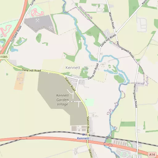
Kennett, in Cambridgeshire, has Kentford situated 1.7 km South East, Red Lodge just 2.5 km North, Herringswell around 2.8 km North East, Moulton just 3.7 km South and Chippenham around 4.0 km West North West. Other places in the surrounding countryside include Needham Street, Badlingham, Landwade and Denham End.
You may find extra local information by clicking a nearby place.
All information is drawn from OS, ONS and OSM under open licence, reflecting the best available public data.
⇅
Local Map
⇅
Location Summary
- Kennett is located in Cambridgeshire
- Administrative Area: Cambridgeshire
- Ceremonial County: Cambridgeshire
- Historic County: Cambridgeshire
- Region & Country: Eastern / England
⇅
Nearby Towns & Cities


⇅
Nearby Localities
- Kentford Village 1.7 km SE
- Red Lodge Village 2.5 km N
- Herringswell Village 2.8 km NE
- Moulton Village 3.7 km S
- ChippenhamVillage 4.0 km WNW
- Gazeley Village 4.6 km SSE
- Freckenham Village 5.0 km NW
- Tuddenham Village 5.0 km NE
- Higham Village 5.2 km ESE
- SnailwellVillage 5.5 km W


⇅
Smaller Settlements
- Needham Street 3.3 km SE
- Badlingham 3.3 km NW
- Landwade 7.5 km W
- Denham End 8.1 km SE
- Dunstall Green 9.0 km SSE
- Upend 9.8 km S
- Woodditton 9.9 km SSW
- Little Ditton 9.9 km SSW
- Wilde Street 10.5 km N
- Back Street 10.5 km SSE

⇅
Beaches
- Brightlingsea Beach64.2 km SE
- Mill Beach63.5 km SSE
- West Mersea Beach64.2 km SSE
⇅
Parks
- Butt Green26.0 km WSW
- Pound Green18.4 km ESE
- Risbridge Meadow21.1 km S
- The Green23.8 km SE

⇅
Woods
- Carrops Plantation953 m N
- Halfmoon Plantation924 m NW
- Nuns Wood1.1 km SSE
- The Willows1.1 km WSW
⇅
Hills
- Chippenham Hill2.7 km SSW
- Dane Hill1.0 km WSW
- Folly Hill3.0 km SSW
- Howe Hill425 m NW
⇅
Lakes
- Bailey Pond10.4 km S
- China Pond10.9 km SE
- Four Ponds5.8 km W
- The Canal3.7 km WNW
⇅
Waterfalls
- Neptune Waterfall98.5 km SW
- The Cascade106.6 km WSW
- Tower Waterfall98.7 km SW
⇅
Headlands
- North Weir Point71.7 km ESE
- West Point89.4 km S
⇅
Islands
- Butten Island22.5 km NE
- The Island17.0 km SSW
⇅
Wetlands
- The Marsh8.4 km WSW
- Chesterton Fen22.8 km WSW
- Gault Hole29.0 km WNW
⇅
Health Services
- Newmarket HospitalHospital 7.2 km WSW
- West Suffolk HospitalHospital 16.1 km ESE
- Kentford ManorMedical 1.7 km S
- Brampton ManorMedical 6.6 km WSW
⇅
Education
- Kennett Community Primary SchoolSchool 170 m SSW
- Kennett Primary SchoolSchool 353 m SW
- West Suffolk CollegeUniversity 14.6 km ESE
⇅
Railway Stations
- Newmarket7.7 km SW
- Soham12.2 km WNW
⇅
Bus Stations
- Mildenhall Bus Station6.6 km NNE
- Haverhill Bus Station22.8 km S
⇅
Coach Stations
- Stansted Airport Coach Station46.7 km SSW
- Luton Airport Bus and Coach Station74.4 km SW
⇅
Ferry Terminals
- Harwich Ferry Port64.3 km SE
- Butley Ferry71.9 km ESE
⇅
Airports
- Cambridge City Airport23.2 km WSW
- Stansted Airport47.4 km SSW
⇅
Airfields
- RAF Mildenhall8.6 km N
- Lakenheath Airfield14.0 km NNE
⇅
Heliports
- The Egerton-Smith Centre23.3 km WSW
- Magpas Air Ambulance51.2 km WNW
⇅
Harbours
- Harwich Harbour66.3 km SE
- Brancaster Harbour78.1 km N