
Leighton Buzzard
About Leighton Buzzard
Leighton Buzzard lies within Central Bedfordshire. Local places nearby include Linslade just 1.2 km West, Leedon only 1.8 km East, Rushmere just 2.8 km North North West and Heath and Reach only 3.2 km North. Other rural localities include Old Linslade, Grove, Little Billington, Ascott and Lower Ascott.
You might discover something new by clicking a nearby place for more local details.
All information is drawn from OS, ONS and OSM under open licence, reflecting the best available public data.
⇅
Local Map
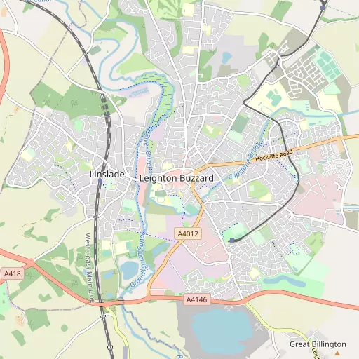
⇅
Location Summary
- Leighton Buzzard is located in Central Bedfordshire
- Administrative Area: Central Bedfordshire
- Ceremonial County: Bedfordshire
- Historic County: Central Bedfordshire
- Region & Country: Eastern / England
⇅
Nearby Towns & Cities
- Woburn 8.5 km NNE
- Houghton Regis 9.8 km E
- Dunstable 10.0 km ESE
- Bletchley 10.0 km NNW
- Milton Keynes 15.4 km NNW


⇅
Nearby Localities
- LinsladeDistrict 1.2 km W
- LeedonDistrict 1.8 km E
- RushmereDistrict 2.8 km NNW
- Heath and ReachVillage 3.2 km N
- BillingtonVillage 3.5 km SE
- LedburnVillage 3.5 km SSW
- EggingtonVillage 3.6 km E
- BurcottVillage 4.4 km WSW
- SlaptonVillage 4.5 km SSE
- SoulburyVillage 4.5 km WNW


⇅
Smaller Settlements
- Old Linslade 2.2 km NW
- Grove 2.6 km S
- Little Billington 2.9 km SSE
- Ascott 3.3 km WSW
- Lower Ascott 3.9 km SW
- Bragenham 4.2 km NNW
- Sheeplane 5.6 km NNE
- Battlesden 5.6 km NE
- Potsgrove 5.6 km NNE
- Hollingdon 5.7 km WNW


⇅
Beaches
- Cotswold Hills Beach93.7 km WSW
- Hadleigh Ray96.1 km ESE
- Mill Beach97.5 km ESE
⇅
Parks
- Balderson's Moor23.1 km SE
- Chaulden Meadow21.9 km SSE
- Elfield Park13.1 km NNW
- The Green18.0 km NNW
⇅
Woods
- Bluebell Wood1.8 km NW
- Chelsea Clump2.6 km SW
- Furze3.0 km W
- Linslade Wood1.8 km NW
⇅
Hills
- Beech Hill8.1 km NE
- Castle Hill6.4 km ESE
- Partridge Hill4.5 km NNW
- Windmill Hill5.0 km SW
⇅
Lakes
- Garden Pond4.4 km SW
- Pinfold Pond7.9 km NNE
- Tebworth Pond7.2 km ENE
- Tiddenfoot Lake1.4 km SSW

⇅
Waterfalls
- Neptune Waterfall27.5 km SSE
- The Cascade27.2 km WNW
- Tower Waterfall27.0 km SSE
⇅
Headlands
- Botany Bay Point56.3 km S
- Tripcock Ness68.9 km SE
⇅
Islands
- Bird Island18.4 km NNE
- Grotto Island25.7 km WSW
⇅
Wetlands
- Cock Marsh38.4 km S
- Summer Leys38.7 km N
- Waterford Marsh40.6 km ESE
⇅
Health Services
- Bletchley Community HospitalHospital 10.8 km NNW
- St Mary's WingHospital 13.1 km E
- Elm Lodge Nursing HomeMedical 766 m WNW
- Leighton Rose Care HomeMedical 1.9 km ENE
⇅
Education
- The Mary Bassett Lower SchoolSchool 247 m NW
- Pulford Lower SchoolSchool 346 m SSW
- The Open UniversityUniversity 12.5 km NNW
⇅
Railway Stations
- Page's Park1.1 km SE
- Stonehenge Works3.1 km NE
⇅
Bus Stations
- Bletchley Bus Station10.1 km NNW
- Aylesbury Bus Station15.4 km SW
⇅
Coach Stations
- Milton Keynes Coachway15.7 km N
- Luton Airport Bus and Coach Station20.1 km ESE
⇅
Ferry Terminals
- Hammerton's Pier57.4 km SSE
- Putney Pier58.6 km SSE
⇅
Airports
- London Luton Airport20.8 km ESE
- Wycombe Air Park35.5 km SSW
⇅
Airfields
- Holmbeck Farm Airfield4.7 km W
- Halton Airfield14.9 km SSW
⇅
Heliports
- Magpas Air Ambulance58.5 km NNE
- The London Heliport59.8 km SE
⇅
Harbours
- Chelsea Harbour59.2 km SE
- Cutter's Dock111.7 km ESE