
Lipson, Plymouth
About Lipson
Lipson is positioned 536 m NE from Plymouth in City of Plymouth. Local places nearby include Lipson Vale situated 536 m North East, Mount Gould around 583 m South East, St Jude's only 652 m South, Mutley around 810 m West North West and Lower Compton lying 1.0 km North. Other local places include Plymstock, Cremyll, St. Stephens Place and Plympton.
You might discover something new by clicking a nearby place for more local details.
The place data here is drawn from OS, ONS and OSM under open licence.
⇅
Local Map
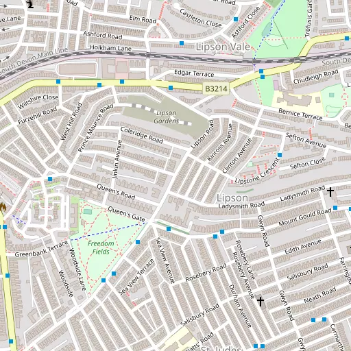
⇅
Location Summary
- Lipson is a neighbourhood in Plymouth
- Administrative Area: City of Plymouth
- Ceremonial County: Devon
- Historic County: City of Plymouth
- Region & Country: South West / England
⇅
Nearby Towns & Cities
⇅
Nearby Localities
⇅
Smaller Settlements
⇅
Beaches
- Mount Batten
- Pebble Side
- Reform Beach
⇅
Parks
- Palm Cross Green
- Pennsylvania Park
- Pleasure Grounds
- The Lawn
⇅
Woods
- Blindman's Wood
- Efford Warren
- Manadon Wood
- Saltram Wood
⇅
Hills
- Amados Hill
- Drake's Hill
- Teats Hill
- The Mound
⇅
Lakes
- Blackie Woods Pond
- Drake's Place Reservoir
- Millbrook Reservoir
- Pennylake Pond
⇅
Waterfalls
- Broad Falls
- Horseshoe Falls
- Yealm Steps
⇅
Headlands
- Hooelake Point
- Mount Batten
⇅
Islands
- Drake's Island
- Great Mew Stone
⇅
Wetlands
- Arnold's Point
- Saltram Point
- May's Marsh
⇅
Health Services
- Local Care Centre
- Royal Eye Infirmary
- Seymour Court Nursing Home
- Pearn Day Care Centre
⇅
Education
- Lipson Vale Primary School
- Salisbury Road Primary School
- Plymouth University
⇅
Train Stations
- Plymouth
- Devonport
⇅
Bus Stations
- Kingsbridge Bus Station
- Exeter Bus Station
⇅
Coach Stations
- Plymouth Coach Station
- Torquay Coach Station
⇅
Ferry Terminals
- Barbican Landing Stage
- Mount Batten Passenger Ferry Terminal
⇅
Airports
- Plymouth City Airport
- Newquay Cornwall Airport
⇅
Airfields
- Bolt Head Airfield
⇅
Heliports
- Cornwall Air Ambulance Station
⇅
Harbours
- Sutton Harbour
- Weston Mill Lake