
Lower Wolvercote, Wolvercote
About Lower Wolvercote
Lower Wolvercote lies 61 m NNE from Wolvercote in Oxfordshire. Local places nearby include Upper Wolvercote only 61 m North North East, Wolvercote situated 414 m North East, Wytham situated 1.4 km West South West and Sunnymead only 2.2 km East. Other nearby settlements include Binsey, Worton, Water Eaton, Gosford and Swinford.
You might discover something new by clicking a nearby place for more local details.
This information is based on OS, ONS and OSM data released under open licence.
⇅
Local Map
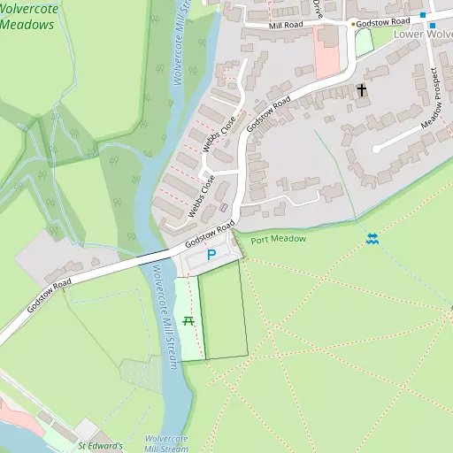
⇅
Location Summary
- Lower Wolvercote is a neighbourhood in Wolvercote
- Administrative Area: Oxfordshire
- Ceremonial County: Oxfordshire
- Historic County: Oxfordshire
- Region & Country: South East / England
⇅
Nearby Towns & Cities
- Parent town: Wolvercote
- Kidlington 4.5 km N
- Woodstock 8.4 km NNW
- Abingdon-on-Thames 12.4 km S
- Witney 13.1 km W
- Oxford 4.2 km SE


⇅
Nearby Localities
- Upper WolvercoteDistrict 61 m NNE
- WolvercoteVillage 414 m NE
- WythamVillage 1.4 km WSW
- SunnymeadDistrict 2.2 km E
- CuttesloweDistrict 2.3 km ENE
- SummertownDistrict 2.4 km ESE
- Walton ManorDistrict 2.8 km SE
- Park TownDistrict 3.0 km ESE
- JerichoDistrict 3.2 km SE
- YarntonVillage 3.2 km NNW


⇅
Smaller Settlements
- Binsey 1.9 km SSE
- Worton 3.1 km NW
- Water Eaton 3.6 km NE
- Gosford 3.9 km NNE
- Swinford 4.4 km WSW
- Filchampstead 5.0 km SW
- Woodeaton 5.4 km ENE
- Oxford Spires Park 5.5 km N
- Eaton 7.4 km SSW
- The Green 7.6 km WNW


⇅
Beaches
- Cotswold Hills Beach47.7 km WSW
- Goatee Beach97.7 km S
- Weston Point99.4 km S
⇅
Parks
- Loop Meadow19.1 km SSE
- Merton Field4.7 km SE
- The Green27.2 km NNE
- The Green33.4 km N
⇅
Woods
- Church Grove1.5 km S
- Godstow Holt893 m SSW
- Marleywood Plantation2.0 km SSW
- Wolvercote Mill Woodland594 m N
⇅
Hills
- Little Ash Hill2.7 km WSW
- Peartree Hill1.7 km NNE
- The Mount1.6 km WSW
- Wytham Hill3.1 km WSW
⇅
Lakes
- Black Jack's Hole1.1 km SSE
- Castle Mill Stream2.7 km SE
- Duke's Cut1.1 km N
- Hagley Pool1.6 km WNW
⇅
Waterfalls
- Neptune Waterfall52.2 km ESE
- The Cascade33.3 km NE
- Tower Waterfall51.5 km ESE
⇅
Headlands
- Beachley Point95.5 km W
- Botany Bay Point63.4 km SE
⇅
Islands
- Fiddler's Island2.6 km SSE
- Isle of Rhea3.3 km ESE
⇅
Wetlands
- Ranger's Marsh18.2 km NW
- Brassey37.0 km WNW
- Wanborough Marsh38.3 km SW
⇅
Health Services
- John Radcliffe HospitalHospital 5.7 km ESE
- The Manor HospitalHospital 6.0 km ESE
- Green GatesMedical 2.0 km E
- Yarnton Nursing HomeMedical 3.2 km NNW
⇅
Education
- Wolvercote Primary SchoolSchool 1.1 km ENE
- St Edward's SchoolSchool 1.5 km ESE
- Oxford University Ewert HouseUniversity 2.3 km ESE
⇅
Railway Stations
- Oxford Parkway2.9 km NNE
- Oxford3.6 km SSE
⇅
Bus Stations
- Aylesbury Bus Station33.3 km E
- High Wycombe Bus Station40.7 km ESE
⇅
Coach Stations
- High Wycombe Coachway41.1 km ESE
- Milton Keynes Coachway51.0 km NE
⇅
Ferry Terminals
- Hampton Ferry Boathouse76.4 km ESE
- Hammerton's Pier77.3 km ESE
⇅
Airports
- London Oxford Airport6.4 km NNW
- Wycombe Air Park38.7 km ESE
⇅
Airfields
- Weston-on-the-Green Airfield12.0 km NNE
- Chalgrove Airfield18.6 km SE
⇅
Heliports
- The London Heliport84.5 km ESE
- Magpas Air Ambulance97.5 km NE
⇅
Harbours
- Lydney Harbour84.0 km W
- Chelsea Harbour84.1 km ESE