
Murchington
About Murchington
Murchington sits within Devon. Nearby places include Throwleigh lying 3.0 km North West, Whiddon Down only 4.2 km North, Drewsteignton around 5.7 km East North East and Ramsley situated 6.0 km North West. Other countryside places nearby include Gidleigh, Teigncombe, Wonson, Forder and Venton.
You may notice something interesting if you explore one of the nearby places.
Information is sourced from OS, ONS and OSM under open licence, using publicly available datasets.
⇅
Local Map
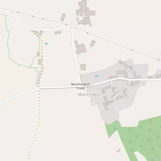
⇅
Location Summary
- Murchington is located in Devon
- Administrative Area: Devon
- Ceremonial County: Devon
- Historic County: Devon
- Region & Country: South West / England
⇅
Nearby Towns & Cities
- Chagford 1.7 km ESE
- Moretonhampstead 7.1 km ESE
- Okehampton 12.0 km WNW
- North Tawton 13.6 km N
- Exeter 23.7 km ENE


⇅
Nearby Localities
- ThrowleighVillage 3.0 km NW
- Whiddon DownVillage 4.2 km N
- DrewsteigntonVillage 5.7 km ENE
- RamsleyDistrict 6.0 km NW
- ShellyDistrict 6.0 km NNW
- South ZealVillage 6.3 km NW
- South TawtonVillage 6.9 km NNW
- North BoveyVillage 7.0 km SE
- SticklepathVillage 7.2 km NW
- CrockernwellVillage 7.9 km ENE


⇅
Smaller Settlements
- Gidleigh 1.4 km W
- Teigncombe 1.8 km SW
- Wonson 1.8 km NW
- Forder 2.0 km NW
- Venton 2.9 km NNE
- Great Weeke 3.0 km ESE
- Easton 3.4 km E
- Lettaford 4.5 km SSE
- Preston 6.7 km ENE
- Hittisleigh 8.2 km NNE


⇅
Beaches
- Powderham Sand28.9 km E
- Shaldon Beach29.7 km ESE
- Starcross Sand29.7 km E
⇅
Parks
- Palm Cross Green36.7 km S
- Pennsylvania Park24.8 km ENE
- Pleasure Grounds11.3 km WNW
- The Lawn29.8 km ESE

⇅
Woods
- Holy Street Wood508 m SSE
- Milfordleigh Plantation528 m S
- The Brake595 m SW
- Woodland Copse570 m W
⇅
Hills
- France Hill2.7 km NNE
- Gidleigh Tor1.5 km WSW
- Meldon Hill2.4 km SSE
- Scorhill Tor3.0 km WSW

⇅
Lakes
- Bradford Pool3.1 km NNE
- Fernworthy Reservoir4.7 km SSW
- Ockerton Court8.3 km WSW
- Shilley Pool4.4 km NW

⇅
Waterfalls
- Becka Falls11.1 km SE
- Horseshoe Falls18.0 km S
- White Lady Waterfall19.1 km WSW
⇅
Headlands
- Bundle Head30.2 km ESE
- The Ness30.2 km ESE
⇅
Islands
- Combestone Island16.0 km S
- Island of Rocks12.9 km W
⇅
Wetlands
- Whitemoor Marsh3.6 km W
- Raybarrow Pool5.1 km WNW
- Taw Marsh6.8 km WNW
⇅
Health Services
- Moretonhampstead HospitalHospital 6.9 km ESE
- Crediton HospitalHospital 18.2 km NE
- Blackdown Nursing HomeMedical 20.0 km WSW
- Hatherleigh Nursing HomeMedical 21.5 km NW

⇅
Education
- Chagford Adult Education CentreSchool 1.7 km E
- Drewsteignton County Primary SchoolSchool 5.5 km ENE
- Duryard Halls of ResidenceUniversity 23.4 km ENE
⇅
Railway Stations
- Okehampton11.2 km WNW
- Sampford Courtenay11.8 km NNW
⇅
Bus Stations
- Exeter Bus Station24.3 km ENE
- Kingsbridge Bus Station44.5 km S
⇅
Coach Stations
- Torquay Coach Station32.4 km SE
- Plymouth Coach Station39.5 km SSW
⇅
Ferry Terminals
- Starcross Pier29.9 km E
- Greenway Quay38.2 km SSE
⇅
Airports
- Exeter Airport32.2 km E
- Plymouth City Airport33.4 km SSW
⇅
Airfields
- Eggesford Airfield20.9 km N
- Eaglescott Airfield29.1 km NNW
⇅
Heliports
- Lake Heliport47.9 km NW
- Hartland Heliport59.5 km NW
⇅
Harbours
- Lympstone Boat Shelter30.4 km E
- New Harbour34.0 km SE