
Old Weston
About Old Weston
Old Weston lies within Cambridgeshire. Local places nearby include Brington lying 1.8 km South West, Leighton Bromswold just 2.4 km South East, Molesworth situated 3.0 km West South West, Winwick only 3.4 km North and Catworth situated 4.3 km South South West. Other countryside places nearby include Barham, Little Catworth, Steeple Gidding and Little Gidding.
You may notice something interesting if you explore one of the nearby places.
This page uses OS, ONS and OSM data supplied under open licence.
⇅
Local Map
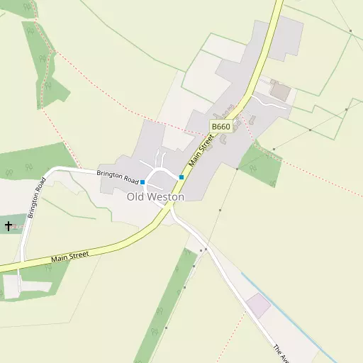
⇅
Location Summary
- Old Weston is located in Cambridgeshire
- Administrative Area: Cambridgeshire
- Ceremonial County: Cambridgeshire
- Historic County: Cambridgeshire
- Region & Country: Eastern / England
⇅
Nearby Towns & Cities
- Thrapston 10.4 km W
- Raunds 10.9 km WSW
- Oundle 12.2 km NNW
- Huntingdon 14.9 km ESE
- Peterborough 23.2 km NNE


⇅
Nearby Localities
- BringtonVillage 1.8 km SW
- Leighton BromswoldVillage 2.4 km SE
- MolesworthVillage 3.0 km WSW
- WinwickVillage 3.4 km N
- CatworthVillage 4.3 km SSW
- HamertonVillage 4.4 km ENE
- BythornVillage 4.6 km WSW
- CloptonVillage 4.6 km NW
- BuckworthVillage 5.0 km E
- SpaldwickVillage 5.4 km SSE


⇅
Smaller Settlements
- Barham 4.3 km ESE
- Little Catworth 4.6 km S
- Steeple Gidding 5.5 km NE
- Little Gidding 5.7 km NE
- Woolley 5.8 km ESE
- Upthorpe 5.9 km SSE
- Luddington in the Brook 6.3 km N
- Coppingford 7.2 km ENE
- Wigsthorpe 7.7 km NW
- Hemington 7.9 km N


⇅
Beaches
- Snettisham Beach77.5 km NE
- Snettisham Scalp78.1 km NE
- Stubborn Sand80.9 km NE
⇅
Parks
- Buckwell Green23.1 km WSW
- Larks Green27.4 km NNE
- New Pasture13.4 km ESE
- Wimpole Park34.9 km SE
⇅
Woods
- Dipslade Coppice2.3 km ENE
- Leighton Gorse2.0 km SSW
- Old Weston Grove1.0 km WSW
- Staunch Hill Plantation2.2 km SSE
⇅
Hills
- Anger Hill4.9 km NE
- Bunkers Hill5.6 km S
- Catworth Hill3.8 km S
- Staunch Hill2.5 km S
⇅
Lakes
- Cesspools8.4 km SW
- Dell Pond4.9 km NE
- Easton Weir6.7 km SE
- Townsend Pond6.8 km NNE
⇅
Waterfalls
- Neptune Waterfall79.3 km S
- The Cascade58.3 km SW
- Tower Waterfall79.1 km S
⇅
Headlands
- Botany Bay Point109.0 km S
- Tripcock Ness102.6 km SSE
⇅
Islands
- Battcock's Island19.5 km ESE
- The Island15.9 km ESE
⇅
Wetlands
- Summer Leys25.3 km WSW
- Ouse Fen27.9 km E
- West Marsh30.4 km N
⇅
Health Services
- Hinchingbrooke HospitalHospital 13.7 km ESE
- Isebrook HospitalHospital 22.2 km WSW
- Latham's HospitalMedical 9.0 km NNW
- Polebrook Nursing HomeMedical 10.2 km NNW
⇅
Education
- Brington Church of England Primary SchoolSchool 2.3 km SW
- Spaldwick Community Primary SchoolSchool 5.7 km SSE
- Tresham College of Further and Higher EducationUniversity 22.1 km W
⇅
Railway Stations
- Huntingdon14.6 km ESE
- St Neots19.2 km SSE
⇅
Bus Stations
- Huntingdon Bus Station15.0 km ESE
- North Gate Bus Station38.3 km WSW
⇅
Coach Stations
- Milton Keynes Coachway42.2 km SSW
- Luton Airport Bus and Coach Station56.1 km S
⇅
Ferry Terminals
- Normanton Chain Ferry73.6 km NW
- Blackfriars Pier98.9 km SSE
⇅
Airports
- Cambridge City Airport43.2 km ESE
- London Luton Airport56.3 km S
⇅
Airfields
- Manor Farm Airfield10.7 km NNE
- RAF Alconbury11.6 km E
⇅
Heliports
- Magpas Air Ambulance9.3 km E
- The Egerton-Smith Centre42.7 km ESE
⇅
Harbours
- Farndon Harbour81.9 km NNW
- Brancaster Harbour96.8 km NE