
Peverell, Plymouth
About Peverell
Peverell lies 812 m ENE from Plymouth in City of Plymouth. Nearby places include Hartley only 812 m East North East, Pennycross around 913 m North North West, Ford Park just 975 m South South East, Mannamead situated 1.1 km East South East and Mutley situated 1.2 km South East. Other settlements in the area include Cremyll, Maryfield, Plymstock and Antony Passage.
You may find extra local information by clicking a nearby place.
Data shown here comes from OS, ONS and OSM under open licence, using the latest public sources available.
⇅
Local Map
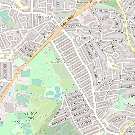
⇅
Location Summary
- Peverell is a neighbourhood in Plymouth
- Administrative Area: City of Plymouth
- Ceremonial County: Devon
- Historic County: City of Plymouth
- Region & Country: South West / England
⇅
Nearby Towns & Cities


⇅
Nearby Localities
- HartleyDistrict 812 m ENE
- PennycrossDistrict 913 m NNW
- Ford ParkDistrict 975 m SSE
- MannameadDistrict 1.1 km ESE
- MutleyDistrict 1.2 km SE
- ManadonDistrict 1.3 km N
- MilehouseDistrict 1.4 km WSW
- Lower ComptonDistrict 1.5 km ESE
- Hartley ValeDistrict 1.5 km ENE
- HamDistrict 1.5 km WNW


⇅
Smaller Settlements
- Cremyll 4.2 km SSW
- Maryfield 5.4 km W
- Plymstock 5.6 km SE
- Antony Passage 6.3 km W
- Roborough 6.4 km NNE
- St. Stephens Place 6.5 km E
- Plympton 6.6 km E
- Landulph 6.7 km NW
- Trehan 7.4 km W
- Spriddlestone 7.4 km SE


⇅
Beaches
- Firestone Bay3.6 km SSW
- Pebble Side3.1 km S
- Reform Beach3.1 km S
⇅
Parks
- Palm Cross Green18.5 km ESE
- Pleasure Grounds39.6 km NNE
- Summerleaze Down56.7 km NNW
- The Lawn52.2 km ENE
⇅
Woods
- Blindman's Wood911 m NE
- Ham Wood1.9 km WNW
- Manadon Wood855 m NNE
- Northdown Plantation2.3 km W

⇅
Hills
- Broomball Hill2.3 km NW
- Drake's Hill2.3 km NW
- Teats Hill2.9 km SSE
- The Mound2.9 km S
⇅
Lakes
- Blackie Woods Pond3.0 km WNW
- Drake's Place Reservoir1.7 km SSE
- Millbrook Reservoir8.0 km SW
- Pennylake Pond5.1 km NW

⇅
Waterfalls
- Broad Falls20.3 km ENE
- White Lady Waterfall26.7 km N
- Yealm Steps15.6 km ENE
⇅
Headlands
- Hooelake Point4.1 km SSE
- Mount Batten3.8 km SSE
⇅
Islands
- Drake's Island4.1 km S
- Great Mew Stone9.7 km SSE
⇅
Wetlands
- Arnold's Point3.1 km ESE
- Saltram Point3.4 km ESE
- Gravesend Hard3.9 km WSW
⇅
Health Services
- Local Care CentreHospital 2.6 km SE
- Royal Eye InfirmaryHospital 3.0 km NNE
- Hartley Park Care HomeMedical 686 m E
- Pearn Day Care CentreMedical 1.2 km E
⇅
Education
- King's School and NurserySchool 515 m E
- Devonport High School for GirlsSchool 563 m WNW
- Plymouth UniversityUniversity 1.8 km S
⇅
Railway Stations
- Plymouth1.5 km S
- Devonport2.4 km SW
⇅
Bus Stations
- Kingsbridge Bus Station28.7 km ESE
- Exeter Bus Station57.4 km NE
⇅
Coach Stations
- Plymouth Coach Station2.1 km S
- Torquay Coach Station44.0 km ENE
⇅
Ferry Terminals
- Barbican Landing Stage3.0 km SSE
- Plymouth International Ferry Terminal3.1 km SSW
⇅
Airports
- Plymouth City Airport4.3 km NE
- Newquay Cornwall Airport62.1 km W
⇅
Airfields
- Bolt Head Airfield30.8 km SE
- Bodmin Airfield38.9 km WNW
⇅
Heliports
- Cornwall Air Ambulance Station59.7 km W
- Lake Heliport71.7 km N
⇅
Harbours
- Sutton Harbour2.7 km SSE
- Weston Mill Lake3.3 km W