
Plympton St Maurice, Plymouth
About Plympton St Maurice
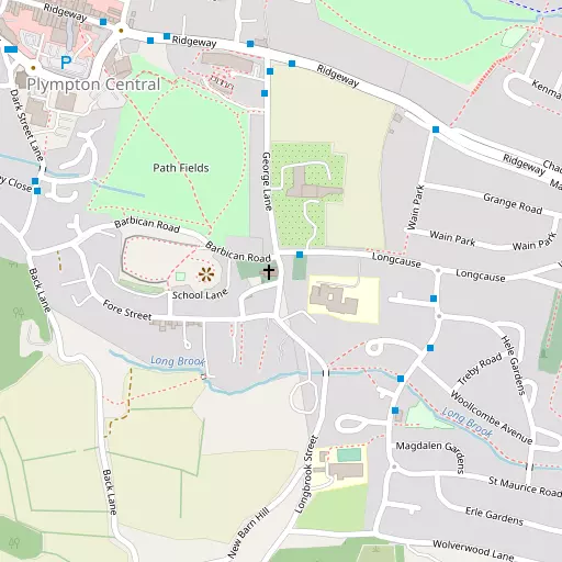
Plympton St Maurice is 970 m ENE from Plymouth in the county of City of Plymouth. Among the nearby places are Chaddlewood only 970 m East North East, Underwood only 1.2 km West North West, Colebrook only 1.4 km North West and Langage lying 2.0 km East North East. Other local places include Plympton, St. Stephens Place, Blackpool, Drakeland Corner and Plymstock.
You may find out something new or interesting if you click a nearby place to see more local information.
Information is sourced from OS, ONS and OSM under open licence, using publicly available datasets.
⇅
Local Map
⇅
Location Summary
- Plympton St Maurice is a neighbourhood in Plymouth
- Administrative Area: City of Plymouth
- Ceremonial County: Devon
- Historic County: City of Plymouth
- Region & Country: South West / England
⇅
Nearby Towns & Cities


⇅
Nearby Localities
- ChaddlewoodDistrict 970 m ENE
- UnderwoodDistrict 1.2 km WNW
- ColebrookDistrict 1.4 km NW
- LangageDistrict 2.0 km ENE
- WoodfordDistrict 2.0 km NW
- HemerdonVillage 2.4 km NE
- Marsh MillsDistrict 2.8 km WNW
- ElburtonDistrict 3.0 km SSW
- CrabtreeDistrict 3.1 km W
- LongbridgeDistrict 3.3 km WNW


⇅
Smaller Settlements
- Plympton 521 m NNW
- St. Stephens Place 574 m NW
- Blackpool 2.5 km SE
- Drakeland Corner 4.0 km NE
- Plymstock 4.2 km SW
- Venton 4.3 km ENE
- Spriddlestone 4.3 km SSW
- Dunstone 6.4 km SE
- Corntown 6.5 km ENE
- The Butts 6.9 km S


⇅
Beaches
- Mount Batten6.4 km WSW
- Pebble Side7.4 km WSW
- Reform Beach7.2 km WSW
⇅
Parks
- Palm Cross Green11.7 km ESE
- Pennsylvania Park54.1 km NE
- Pleasure Grounds39.2 km N
- The Lawn46.4 km ENE


⇅
Woods
- Binicliff Wood1.8 km N
- Hardwick Wood1.6 km W
- Holly Wood1.9 km NNE
- Plympton Covert543 m W

⇅
Hills
- Amados Hill1.5 km W
- Dorsmouth Rock795 m W
- Hemerdon Ball3.5 km NE
- Higher Hareston3.1 km SE
⇅
Lakes
- Blachford Fish Pond7.7 km NE
- Drake's Place Reservoir6.5 km W
- Drakelands Trout Lake4.0 km NE
- The Clam5.4 km SE
⇅
Waterfalls
- Broad Falls15.5 km NE
- Horseshoe Falls22.0 km NE
- Yealm Steps10.7 km NE
⇅
Headlands
- Hooelake Point5.5 km WSW
- Steer Point5.7 km S
⇅
Islands
- Drake's Island8.2 km WSW
- Head Weir Island9.4 km ESE
⇅
Wetlands
- May's Marsh3.1 km WNW
- Saltram Point3.8 km W
- Arnold's Point4.2 km W
⇅
Health Services
- Local Care CentreHospital 4.8 km W
- Lee Mill HospitalHospital 6.1 km E
- The Long Brook Residential HomeMedical 251 m WSW
- Merafield ViewMedical 1.1 km WNW
⇅
Education
- Longcause Community Special SchoolSchool 112 m E
- Plympton St Maurice Primary SchoolSchool 375 m SSE
- Plymouth UniversityUniversity 5.8 km NW
⇅
Railway Stations
- Marsh Mills2.9 km WNW
- Plymbridge Wood3.6 km NW
⇅
Bus Stations
- Kingsbridge Bus Station22.2 km ESE
- Exeter Bus Station53.0 km NE
⇅
Coach Stations
- Plymouth Coach Station7.0 km W
- Torquay Coach Station37.5 km ENE
⇅
Ferry Terminals
- Mount Batten Passenger Ferry Terminal6.4 km WSW
- Barbican Landing Stage6.5 km WSW
⇅
Airports
- Plymouth City Airport6.2 km NW
- Exeter Airport59.4 km NE
⇅
Airfields
- Bolt Head Airfield25.0 km SE
- Bodmin Airfield45.8 km WNW
⇅
Heliports
- Cornwall Air Ambulance Station66.6 km W
- Lake Heliport73.6 km N
⇅
Harbours
- Sutton Harbour6.3 km WSW
- Fort Picklecombe Harbour9.8 km WSW