
Prickwillow
About Prickwillow
Prickwillow, in Cambridgeshire, has Queen Adelaide only 2.8 km West South West, Chettisham only 4.4 km West North West, Littleport just 5.2 km North North West, Stuntney just 5.5 km South West and Little Downham situated 7.1 km West North West. Other nearby hamlets and settlements include Mile End, Redmere, Broad Hill and Barcham Corner.
You might learn something new by clicking through to a nearby place.
The place data here is drawn from OS, ONS and OSM under open licence.
⇅
Local Map
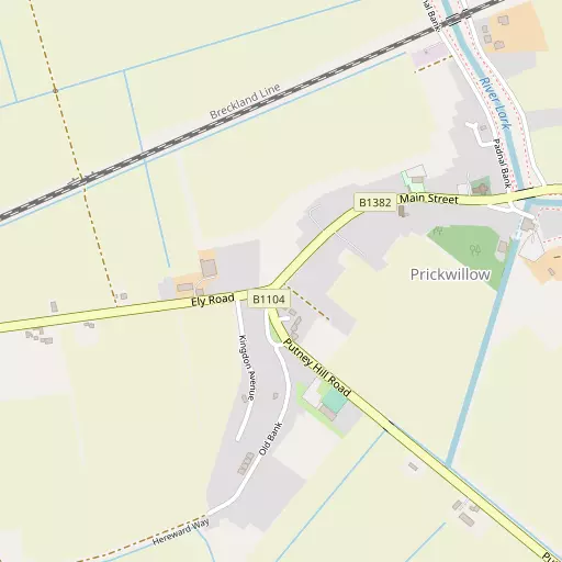
⇅
Location Summary
- Prickwillow is located in Cambridgeshire
- Administrative Area: Cambridgeshire
- Ceremonial County: Cambridgeshire
- Historic County: Cambridgeshire
- Region & Country: Eastern / England
⇅
Nearby Towns & Cities


⇅
Nearby Localities
- Queen AdelaideVillage 2.8 km WSW
- ChettishamVillage 4.4 km WNW
- LittleportVillage 5.2 km NNW
- StuntneyVillage 5.5 km SW
- Little DownhamVillage 7.1 km WNW
- North FieldDistrict 7.4 km S
- Little OuseVillage 7.5 km NNE
- Soham CotesDistrict 7.9 km SSW
- Little ThetfordVillage 8.5 km SW
- Black Horse DroveVillage 8.8 km N


⇅
Smaller Settlements
- Mile End 1.3 km ENE
- Redmere 5.3 km ENE
- Broad Hill 5.5 km S
- Barcham Corner 6.4 km S
- Black Bank 6.7 km WNW
- Brandon Bank 7.6 km NNE
- Kenny Hill 7.8 km ESE
- Barway 8.0 km SW
- Westlands 8.2 km NW
- Dunkirk 8.5 km WNW


⇅
Beaches
- Snettisham Beach50.2 km N
- Snettisham Scalp51.6 km N
- Stubborn Sand54.5 km N
⇅
Parks
- Butt Green27.1 km SSW
- Empty Common28.9 km SSW
- Pound Green35.3 km SE
- Risbridge Meadow36.9 km SSE
⇅
Woods
- Cowground Plantation3.1 km ENE
- Redmoor Plantation3.6 km WNW
- Stonehorse Plantation2.7 km NE
- The Rookery4.3 km SSW

⇅
Hills
- Brick Hill3.3 km WNW
- Hainey Hill7.6 km SSW
- Quanea Hill3.2 km SW
- Thorney Hill3.4 km SSW
⇅
Lakes
- Brook Dam9.3 km S
- Roswell Pits4.0 km WSW
- Sandall's Cut4.5 km NNW
- The Dock5.4 km NNW
⇅
Waterfalls
- Neptune Waterfall102.4 km SW
- The Cascade102.0 km WSW
- Tower Waterfall102.5 km SW
⇅
Headlands
- North Weir Point86.9 km ESE
- Tripcock Ness102.2 km S
⇅
Islands
- Birdcage Island23.4 km NE
- Butten Island27.6 km E
⇅
Wetlands
- Gault Hole15.7 km W
- The Marsh17.8 km S
- Ouse Fen23.6 km WSW

⇅
Health Services
- Princess of Wales HospitalHospital 4.4 km W
- Newmarket HospitalHospital 18.7 km SSE
- The GrangeMedical 4.7 km NW
- The LimesMedical 5.2 km NNW
⇅
Education
- Ely St Mary's Church of England Junior SchoolSchool 4.4 km W
- Spring Meadow Infant and Nursery SchoolSchool 4.5 km WSW
- College of West AngliaUniversity 21.9 km SSW
⇅
Railway Stations
- Shippea Hill5.2 km ENE
- Littleport5.5 km NNW
⇅
Bus Stations
- Mildenhall Bus Station14.2 km SE
- Drummer Street Bus Station27.6 km SSW
⇅
Coach Stations
- Stansted Airport Coach Station58.8 km S
- Luton Airport Bus and Coach Station77.1 km SW
⇅
Ferry Terminals
- Harwich Ferry Port81.1 km SE
- Reedham Ferry North83.4 km ENE
⇅
Airports
- Cambridge City Airport26.1 km SSW
- Stansted Airport59.1 km S
⇅
Airfields
- RAF Mildenhall11.6 km ESE
- Lakenheath Airfield14.7 km E
⇅
Heliports
- The Egerton-Smith Centre25.9 km SSW
- Magpas Air Ambulance40.2 km W
⇅
Harbours
- Brancaster Harbour66.3 km NNE
- Harwich Harbour82.9 km SE