
Rotherfield Greys
About Rotherfield Greys
Rotherfield Greys, in Oxfordshire, has Rotherfield Peppard lying 1.7 km West South West, Peppard Hill just 2.6 km West South West, Kingwood Common only 2.7 km West and Sonning Common situated 2.7 km South West. Other rural settlements include Greys Green, Shepherd's Green, Satwell, Harpsden Bottom and Crowsley.
You may find out something new or interesting if you click a nearby place to see more local information.
The place data here is drawn from OS, ONS and OSM under open licence.
⇅
Local Map
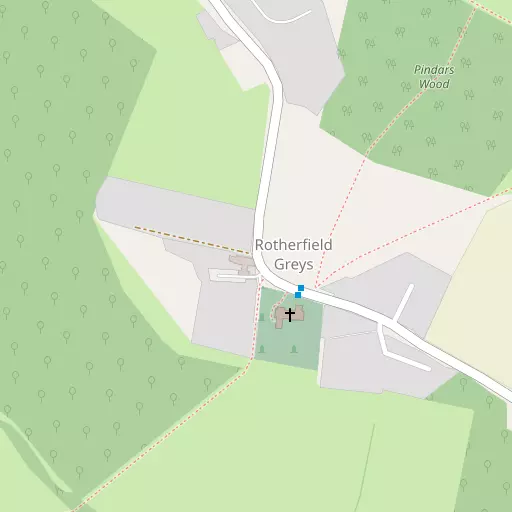
⇅
Location Summary
- Rotherfield Greys is located in Oxfordshire
- Administrative Area: Oxfordshire
- Ceremonial County: Oxfordshire
- Historic County: Oxfordshire
- Region & Country: South East / England
⇅
Nearby Towns & Cities
- Henley-on-Thames 3.5 km E
- Reading 9.2 km S
- Woodley 9.7 km SSE
- Watlington 12.7 km NNW
- Oxford 31.9 km NW


⇅
Nearby Localities
- Rotherfield PeppardVillage 1.7 km WSW
- Peppard HillVillage 2.6 km WSW
- Kingwood CommonVillage 2.7 km W
- Sonning CommonVillage 2.7 km SW
- BixVillage 2.8 km N
- Lower AssendonVillage 2.9 km NE
- Highmoor CrossVillage 3.3 km WNW
- Middle AssendonVillage 3.5 km NNE
- NewtownDistrict 3.8 km E
- Harpsden HeightsDistrict 3.9 km ESE


⇅
Smaller Settlements
- Greys Green 542 m NNW
- Shepherd's Green 1.8 km WNW
- Satwell 2.3 km WNW
- Harpsden Bottom 2.9 km SE
- Crowsley 2.9 km S
- Lower Highmoor 3.4 km NW
- Highmoor 3.6 km NW
- Catslip 4.5 km NNW
- Shiplake Row 4.7 km SSE
- Remenham 4.7 km ENE


⇅
Beaches
- Cotswold Hills Beach70.9 km WNW
- Weston Point77.8 km SSW
- Weston Shelf78.2 km SSW

⇅
Parks
- Ascot Heath23.3 km SE
- Hog Common25.1 km ESE
- Loop Meadow21.6 km WNW
- The Common5.8 km S
⇅
Woods
- Packam Plantation941 m E
- Pindars Wood240 m NE
- Silgrove Wood629 m SSE
- The Paddock873 m SSW
⇅
Hills
- Drawback Hill3.2 km ESE
- Kent's Hill1.3 km S
- King's Hill2.1 km S
- Lambridge Hill2.4 km NE
⇅
Lakes
- Crockmore Pond3.9 km NE
- Goldfish Pond4.3 km WSW
- Henley Reach4.4 km ENE
- Widmore Pond2.2 km SW
⇅
Waterfalls
- Neptune Waterfall31.7 km ENE
- The Cascade54.8 km N
- Tower Waterfall31.3 km ENE
⇅
Headlands
- Botany Bay Point28.4 km ESE
- Tripcock Ness72.4 km E
⇅
Islands
- Rod Eyot Islands4.1 km E
- Town Rod Eyot4.2 km E
⇅
Wetlands
- Wargrave Marsh6.1 km ESE
- Cock Marsh16.4 km ENE
- Midgham Marsh23.7 km SW
⇅
Health Services
- Townlands Memorial HospitalHospital 3.2 km E
- Joyce GroveHospital 4.9 km NNW
- Acacia LodgeMedical 3.9 km E
- Lashbrook House Nursing HomeMedical 6.1 km SE
⇅
Education
- Peppard Church of England Primary SchoolSchool 1.7 km WSW
- Valley Road SchoolSchool 2.4 km ESE
- Henley Business School University of ReadingUniversity 5.4 km ENE
⇅
Railway Stations
- Henley-on-Thames3.8 km E
- Shiplake5.7 km ESE
⇅
Bus Stations
- High Wycombe Bus Station17.3 km NE
- Bracknell Bus Station19.6 km SE
⇅
Coach Stations
- High Wycombe Coachway15.8 km ENE
- Luton Airport Bus and Coach Station55.2 km NE
⇅
Ferry Terminals
- Hampton Ferry Boathouse43.2 km ESE
- Hammerton's Pier45.4 km ESE
⇅
Airports
- Wycombe Air Park13.1 km NE
- Blackbushe Airport24.7 km SSE
⇅
Airfields
- White Waltham Airfield13.1 km ESE
- RAF Benson13.2 km NW
⇅
Heliports
- The London Heliport54.2 km E
- Kent Surrey Sussex Air Ambulance103.4 km E
⇅
Harbours
- Chelsea Harbour53.9 km E
- Hendy's Quay77.0 km S