
Shabbington
About Shabbington
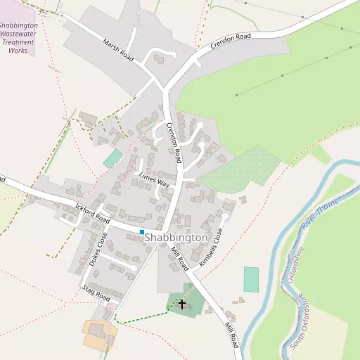
Shabbington sits within Buckinghamshire. Local places nearby include Ickford around 1.6 km West, Tiddington lying 2.4 km South West, Worminghall around 2.9 km West North West and Long Crendon lying 3.5 km East North East. Other countryside settlements include Little Ickford, Albury, Waterstock, Easington and Townsend.
You may notice something interesting if you explore one of the nearby places.
The details shown here use OS, ONS and OSM data provided under open licence.
⇅
Local Map
⇅
Location Summary
- Shabbington is located in Buckinghamshire
- Administrative Area: Buckinghamshire
- Ceremonial County: Buckinghamshire
- Historic County: Buckinghamshire
- Region & Country: South East / England
⇅
Nearby Towns & Cities
- Thame 4.0 km ESE
- Watlington 12.7 km S
- Princes Risborough 14.5 km ESE
- Aylesbury 16.8 km ENE
- Oxford 15.3 km W


⇅
Nearby Localities
- IckfordVillage 1.6 km W
- TiddingtonVillage 2.4 km SW
- WorminghallVillage 2.9 km WNW
- Long CrendonVillage 3.5 km ENE
- MoretonVillage 3.7 km SE
- Milton CommonVillage 3.8 km SSW
- WaterperryVillage 4.0 km W
- ChiltonVillage 4.9 km NNE
- Great MiltonVillage 5.5 km SW
- TetsworthVillage 5.7 km SSE


⇅
Smaller Settlements
- Little Ickford 1.3 km W
- Albury 2.2 km SSW
- Waterstock 3.2 km WSW
- Easington 4.0 km NNE
- Townsend 4.3 km W
- Little Haseley 6.8 km SSW
- Lower Pollicott 7.1 km NNE
- Honeyburge 7.6 km NW
- Upper Pollicott 7.6 km NNE
- Stoke Talmage 7.9 km S


⇅
Beaches
- Cotswold Hills Beach64.6 km W
- Goatee Beach99.0 km SSW
- Weston Point99.5 km SSW
⇅
Parks
- Loop Meadow21.4 km SW
- Merton Field14.8 km W
- The Common30.9 km S
- The Green28.9 km NNW

⇅
Woods
- Colesheath Copse1.7 km S
- Fernhill Wood2.7 km SSW
- Old Paddock2.7 km SSE
- Tiddington Copse2.8 km SSW
⇅
Hills
- Castle Hill6.7 km WSW
- Cop Hill4.0 km ENE
- Horsenden Hill5.2 km SSE
- Lobbersdown Hill3.6 km SSE
⇅
Lakes
- Banks Pond7.8 km ENE
- Lenton's Pond5.4 km ENE
- Milton Pools4.2 km SSW
- Rycote Lake2.2 km SSE
⇅
Waterfalls
- Neptune Waterfall34.2 km ESE
- The Cascade30.0 km N
- Tower Waterfall33.5 km ESE

⇅
Headlands
- Botany Bay Point49.0 km SE
- Tripcock Ness82.6 km ESE
⇅
Islands
- China Island9.2 km N
- The Island6.9 km S
⇅
Wetlands
- Wargrave Marsh29.3 km SSE
- Cock Marsh29.7 km SE
- Ranger's Marsh35.2 km WNW
⇅
Health Services
- Thame Community HospitalHospital 4.8 km ESE
- The Churchill HospitalHospital 12.2 km W
- Meadowcroft Care HomeMedical 5.2 km ESE
- The Triangle Care HomeMedical 6.5 km W
⇅
Education
- Ickford SchoolSchool 1.7 km WNW
- Lord William's SchoolSchool 3.2 km ESE
- Wheatley CampusUniversity 6.5 km W
⇅
Railway Stations
- Haddenham and Thame Parkway6.5 km ENE
- Chinnor11.2 km SE
⇅
Bus Stations
- Aylesbury Bus Station16.6 km ENE
- High Wycombe Bus Station23.8 km SE
⇅
Coach Stations
- High Wycombe Coachway24.6 km SE
- Milton Keynes Coachway40.4 km NE

⇅
Ferry Terminals
- Hampton Ferry Boathouse60.3 km SE
- Hammerton's Pier60.7 km SE
⇅
Airports
- London Oxford Airport21.4 km WNW
- Wycombe Air Park22.8 km SE
⇅
Airfields
- Chalgrove Airfield9.6 km SSW
- RAF Benson16.2 km SSW
⇅
Heliports
- The London Heliport67.3 km ESE
- Magpas Air Ambulance87.4 km NE
⇅
Harbours
- Chelsea Harbour66.8 km ESE
- Ocean Dock99.5 km SSW