
South End, Keelby
About South End
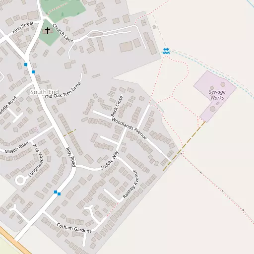
South End is positioned 363 m NW from Keelby in Lincolnshire. Among the nearby places are Keelby around 363 m North West, Riby only 2.7 km South East, Brocklesby just 3.1 km North West and Great Limber only 3.5 km West South West. Other places nearby include Little London, Croxton, Cabourne, Clixby and Cuxwold.
You may find extra local information by clicking a nearby place.
These details are compiled from OS, ONS and OSM data released under open licence.
⇅
Local Map
⇅
Location Summary
- South End is a neighbourhood in Keelby
- Administrative Area: Lincolnshire
- Ceremonial County: Lincolnshire
- Historic County: Lincolnshire
- Region & Country: East Midlands / England
⇅
Nearby Towns & Cities
- Parent town: Keelby
- Immingham 5.3 km NNE
- Grimsby 10.3 km E
- Cleethorpes 13.9 km E
- Brigg 16.5 km W
- Kingston upon Hull 20.2 km NNW


⇅
Nearby Localities
- KeelbyVillage 363 m NW
- RibyVillage 2.7 km SE
- BrocklesbyVillage 3.1 km NW
- Great LimberVillage 3.5 km WSW
- Stallingborough Village 4.0 km ENE
- Aylesby Village 4.1 km ESE
- Habrough Village 4.4 km NNW
- Healing Village 5.3 km ENE
- Irby upon Humber Village 5.5 km SSE
- Laceby Village 5.7 km SE


⇅
Smaller Settlements


⇅
Other places with this name
- South End, North Lincolnshire 12.1 km NNW
- South End, East Riding of Yorkshire 30.5 km N
- South End, Norfolk 144.8 km SSE
- South End, Bedford161.9 km S
- South End, Buckinghamshire178.0 km SSW
- South End, Central Bedfordshire180.5 km S
- South End, Buckinghamshire187.1 km S

⇅
Beaches
- Cleethorpes Beach14.5 km E
- Humberston Fitties Beach17.3 km ESE
- Tetney High Sands19.9 km ESE
⇅
Parks
- Doncaster Common56.6 km W
- Leeman Park71.7 km NW
- West Green53.4 km NW
- Wilsford Warren67.6 km SSW
⇅
Woods
- Hunger Hill Wood2.3 km ESE
- Miller's Wood2.4 km WNW
- Roxton Wood2.2 km NNW
- Suddle Wood948 m ESE
⇅
Hills
- Caen Hill4.9 km SSW
- Mere Hill4.6 km WNW
- Primrose Hill2.2 km NW
- Round Hill5.1 km S
⇅
Lakes
- Dam Bottom3.8 km NW
- Lambert Hill Pond4.4 km NW
- Newsham Lake5.0 km NW
- The Canal3.4 km WNW
⇅
Waterfalls
- Birch Fall96.0 km NNW
- Nelly Ayre Foss96.5 km NNW
- Stevenson's Piece96.5 km NNW
⇅
Headlands
- Flamborough Head61.5 km N
- Red Cliff Point74.8 km N
⇅
Islands
- Read's Island24.8 km WNW
- Whitton Island32.4 km WNW
⇅
Wetlands
- Killingholme Marshes9.1 km N
- Halton Marshes12.1 km N
- Foulholme Sands12.4 km NNE
⇅
Health Services
- Bradley Complex CareHospital 8.5 km ESE
- Diana Princess of Wales HospitalHospital 9.9 km ESE
- Stallingborough LodgeMedical 3.5 km ENE
- HavenmereMedical 5.5 km NNE
⇅
Education
- Keelby Primary SchoolSchool 495 m NW
- Brocklesby Park Primary SchoolSchool 2.7 km WSW
- Grimsby Institute of Further and Higher EducationUniversity 9.8 km ESE
⇅
Railway Stations
- Stallingborough4.1 km ENE
- Habrough4.3 km NNW
⇅
Bus Stations
- Barton Bus Station18.8 km NW
- Scunthorpe Bus Station26.7 km W
⇅
Coach Stations
- Meadowhall Interchange79.5 km WSW
- Chesterfield Coach Station87.3 km WSW
⇅
Ferry Terminals
- Hull Ferry Port19.4 km N
- Normanton Chain Ferry108.2 km SW
⇅
Airports
- Humberside Airport7.3 km W
- Wickenby Aerodrome29.2 km SSW
⇅
Airfields
- Hibaldstow Airfield20.2 km WSW
- North Coates Airfield21.5 km ESE
⇅
Heliports
- Lincs and Notts Air Ambulance HQ47.9 km SSW
- Nottingham Heliport97.0 km SSW
⇅
Harbours
- South Killingholme Haven7.7 km NNE
- Old Harbour19.9 km NNW