
Southville, Kingsbridge
About Southville
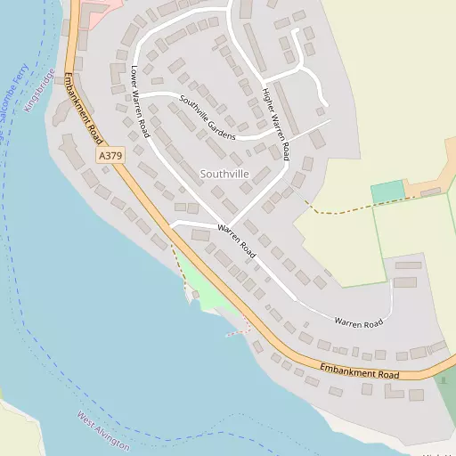
Southville sits 1.0 km ESE of Kingsbridge in Devon. Among the nearby places are West Charleton around 1.0 km East South East, Dodbrooke just 1.2 km North North West, Westville only 1.2 km North West and West Alvington just 1.7 km West North West. Other communities nearby include Easton, East Charleton, Woolston, Lower Batson and Ledstone.
You may find extra local information by clicking a nearby place.
This information is based on OS, ONS and OSM data released under open licence.
⇅
Local Map
⇅
Location Summary
- Southville is a neighbourhood in Kingsbridge
- Administrative Area: Devon
- Ceremonial County: Devon
- Historic County: Devon
- Region & Country: South West / England
⇅
Nearby Towns & Cities
- Parent town: Kingsbridge
- Kingsbridge 1.2 km NNW
- Salcombe 4.1 km S
- Dartmouth 15.9 km ENE
- Ivybridge 16.7 km NW
- Plymouth 28.5 km WNW


⇅
Nearby Localities
- West CharletonVillage 1.0 km ESE
- DodbrookeDistrict 1.2 km NNW
- WestvilleDistrict 1.2 km NW
- West AlvingtonVillage 1.7 km WNW
- GovetonVillage 3.5 km NNE
- FrogmoreVillage 3.6 km E
- Higher BatsonVillage 3.6 km S
- ChurchstowVillage 3.9 km NW
- SherfordVillage 4.0 km ENE
- South MiltonVillage 4.3 km W


⇅
Smaller Settlements
- Easton 1.5 km WSW
- East Charleton 2.4 km E
- Woolston 2.8 km WSW
- Lower Batson 3.4 km S
- Ledstone 3.5 km N
- Sorley 3.7 km NNW
- Upton 3.8 km W
- Sutton 3.8 km W
- Warcombe 4.3 km N
- Hatch 4.8 km NW


⇅
Other places with this name
- Southville, City of Bristol 153.5 km NNE
- Southville, Torfaen - Torfaen 161.5 km NNE
⇅
Beaches
- North Sands5.1 km S
- Rickham Sand6.4 km SSE
- South Sands5.5 km S

⇅
Parks
- Palm Cross Green12.0 km NW
- Pennsylvania Park54.4 km NNE
- Pleasure Grounds53.6 km NNW
- The Lawn40.2 km NNE
⇅
Woods
- Iltoncastle Plantation2.3 km S
- The Grove2.7 km WNW
- Wall Park2.8 km SE
- West Alvington Wood1.9 km WNW

⇅
Hills
- Batt's Hill3.9 km NNE
- Clematon Hill8.5 km W
- Hines Hill8.0 km SSE
- Mount Folly7.9 km WNW
⇅
Lakes
- Higher Ley9.2 km ENE
- Old Mill Leat6.1 km NW
- Slapton Ley8.3 km E
- Widdicombe Ley8.2 km ESE
⇅
Waterfalls
- Broad Falls25.4 km NNW
- Horseshoe Falls27.5 km N
- Yealm Steps23.9 km NNW
⇅
Headlands
- Halwell Point2.8 km SSE
- Snapes Point3.9 km S
⇅
Islands
- Burgh Island9.2 km W
- Little Island9.4 km W
⇅
Wetlands
- Saddle1.2 km SSE
- Charleton Point1.7 km SSE
- Ditch End4.3 km S
⇅
Health Services
- South Hams HospitalHospital 1.8 km NNW
- Totnes HospitalHospital 18.6 km NNE
- Ivydene Nursing HomeMedical 16.3 km NW
- BeaconvilleMedical 17.2 km NW
⇅
Education
- Kingsbridge Community CollegeSchool 1.1 km NW
- Kingsbridge Community Primary SchoolSchool 1.5 km N
- Schumacher CollegeUniversity 20.2 km NNE
⇅
Railway Stations
- Ivybridge16.2 km NW
- Kingswear16.3 km ENE
⇅
Bus Stations
- Kingsbridge Bus Station1.1 km NNW
- Exeter Bus Station53.1 km NNE
⇅
Coach Stations
- Torquay Coach Station27.7 km NE
- Plymouth Coach Station28.7 km WNW

⇅
Ferry Terminals
- South Sands5.6 km S
- Dartmouth South Embankment15.9 km ENE
⇅
Airports
- Plymouth City Airport29.2 km NW
- Exeter Airport57.1 km NNE
⇅
Airfields
- Bolt Head Airfield5.9 km SSW
- Farway Common Airfield66.2 km NE

⇅
Heliports
- Cornwall Air Ambulance Station87.9 km WNW
- Lake Heliport90.9 km NNW
⇅
Harbours
- Salcombe Harbour4.7 km S
- Dartmouth16.1 km ENE