
St Merryn
About St Merryn
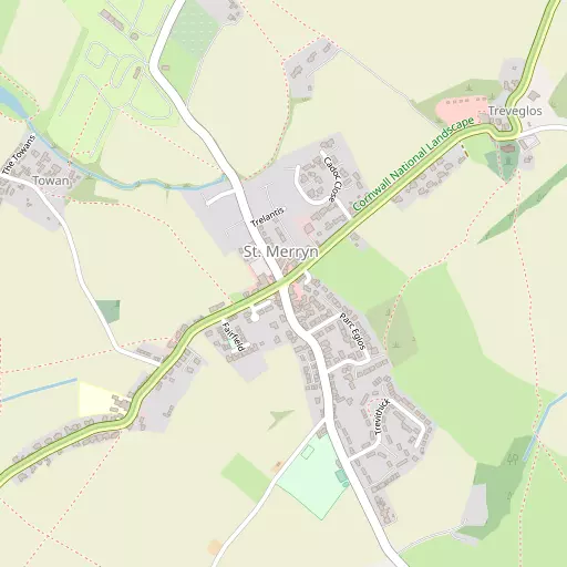
St Merryn lies within Cornwall. Among the nearby places are Shop situated 342 m South West, Harlyn lying 1.4 km North North West, Constantine Bay around 1.5 km West North West and Treyarnon around 1.8 km West. Other rural localities include Towan, Treator, Highlanes, Trethillick and Crugmeer.
You might discover something new by clicking a nearby place for more local details.
This information is based on OS, ONS and OSM data released under open licence.
⇅
Local Map
⇅
Location Summary
- St Merryn is located in Cornwall
- Administrative Area: Cornwall
- Ceremonial County: Cornwall
- Historic County: Cornwall
- Region & Country: South West / England
⇅
Nearby Towns & Cities
- Padstow 4.0 km ENE
- St Columb Major 10.7 km SSE
- Wadebridge 11.0 km E
- Newquay 14.1 km SSW
- Truro 29.5 km S


⇅
Nearby Localities
- ShopDistrict 342 m SW
- HarlynVillage 1.4 km NNW
- Constantine BayVillage 1.5 km WNW
- TreyarnonVillage 1.8 km W
- TrevoneVillage 2.1 km NNE
- PorthcothanVillage 2.6 km SW
- PenroseVillage 3.1 km S
- TregonnaVillage 3.8 km ESE
- RumfordVillage 4.0 km SSE
- St IsseyVillage 5.1 km ESE


⇅
Smaller Settlements
- Towan 712 m WNW
- Treator 2.7 km ENE
- Highlanes 3.2 km ESE
- Trethillick 3.3 km NE
- Crugmeer 3.3 km NE
- St Ervan 3.7 km SSE
- Little Petherick 4.1 km ESE
- Trevorrick 4.1 km E
- Engollan 4.2 km SSW
- Tregonce 4.8 km E

⇅
Beaches
- Harlyn Beach1.8 km NNW
- Porthcothan Beach3.1 km WSW
- Treyarnon Beach2.4 km W

⇅
Parks
- Lanner Moor37.4 km SSW
- Pleasure Grounds73.9 km ENE
- Summerleaze Down46.4 km NE
- Trungle Moor62.8 km SW
⇅
Woods
- Carnanton Woods9.9 km S
- Menadews Plantation8.6 km SSE
- Tregolds Plantation4.6 km ESE
- Trevillador Wood5.1 km SE

⇅
Hills
- Ball Hill5.6 km E
- Brea Hill5.7 km NE
- Cassock Hill5.3 km ENE
- Dennis Hill4.1 km E
⇅
Lakes
- Dennis Cove Lake4.0 km E
- Porth Reservoir11.8 km S
- Ruthvoes Reservoir14.1 km SSE
- Tresaddern Water11.7 km SSE
⇅
Waterfalls
- Golitha Falls34.5 km E
- White Lady Waterfall62.5 km E
- Yealm Steps74.1 km E
⇅
Headlands
- Cataclews Point2.4 km NNW
- Pentonwarra Point2.3 km NNE
⇅
Islands
- Diggory's Island5.0 km SW
- Trethias Island2.6 km W
⇅
Wetlands
- St Saviour's Point4.7 km ENE
- Town Bar4.8 km ENE
- Gun Point4.8 km NE
⇅
Health Services
- Newquay HospitalHospital 14.1 km SSW
- Bodmin Community HospitalHospital 18.8 km ESE
- Windmill CourtMedical 9.9 km ENE
- St BreokMedical 10.8 km E
⇅
Education
- St Merryn SchoolSchool 502 m WSW
- Padstow SchoolSchool 3.4 km ENE
- Cornwall CollegeUniversity 13.9 km SSW
⇅
Railway Stations
- Newquay13.7 km SSW
- Quintrell Downs13.8 km S
⇅
Bus Stations
- Newquay Bus Station14.2 km SSW
- Truro Bus Station29.6 km S
⇅
Coach Stations
- Plymouth Coach Station62.4 km ESE
- Torquay Coach Station103.1 km E
⇅
Ferry Terminals
- Caffa Mill Slipway32.7 km SE
- Bodinnick32.9 km SE
⇅
Airports
- Newquay Cornwall Airport9.6 km S
- Plymouth City Airport63.5 km E
⇅
Airfields
- St Merryn Airfield2.5 km SSE
- Bodmin Airfield23.2 km E
⇅
Heliports
- Cornwall Air Ambulance Station10.4 km S
- Penzance Heliport57.5 km SW
⇅
Harbours
- Charlestown Docks27.3 km SE
- Par Harbour28.7 km SE