
Taddiport, Great Torrington
About Taddiport
Taddiport lies 1.8 km S from Great Torrington in Devon. Neighbouring places include Little Torrington just 1.8 km South, Frithelstock Stone around 3.3 km West, Monkleigh situated 4.0 km West North West, Weare Giffard around 4.3 km North North West and St Giles in the Wood only 4.5 km East. Other places in the wider area include Frithelstock, Helestone Park, Stowford and Lake.
You might discover something new by clicking a nearby place for more local details.
All information is drawn from OS, ONS and OSM under open licence, reflecting the best available public data.
⇅
Local Map
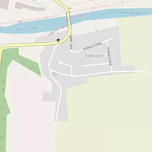
⇅
Location Summary
- Taddiport is a neighbourhood in Great Torrington
- Administrative Area: Devon
- Ceremonial County: Devon
- Historic County: Devon
- Region & Country: South West / England
⇅
Nearby Towns & Cities
- Parent town: Great Torrington
- Great Torrington 946 m NE
- Bideford 8.6 km NNW
- Northam 11.3 km NNW
- Barnstaple 16.4 km NNE
- Exeter 50.2 km ESE


⇅
Nearby Localities
- Little TorringtonVillage 1.8 km S
- Frithelstock StoneVillage 3.3 km W
- MonkleighVillage 4.0 km WNW
- Weare GiffardVillage 4.3 km NNW
- St Giles in the WoodVillage 4.5 km E
- LangtreeVillage 4.8 km SW
- Stibb CrossVillage 6.7 km SW
- LittlehamVillage 6.9 km NW
- Buckland BrewerVillage 7.2 km WNW
- BeafordVillage 7.3 km ESE


⇅
Smaller Settlements
- Frithelstock 2.6 km WNW
- Helestone Park 3.3 km W
- Stowford 3.4 km SSW
- Lake 4.0 km SSW
- Berry Cross 4.3 km SSW
- Huntshaw 4.7 km NNE
- Kingscott 4.9 km E
- High Bullen 5.0 km ENE
- Peters Marland 5.2 km S
- Hallspill 5.3 km NNW


⇅
Beaches
- Horsey Ridge14.5 km N
- Instow Beach12.5 km N
- Westward Ho! Beach12.8 km NNW

⇅
Parks
- Pennsylvania Park50.0 km ESE
- Pleasure Grounds26.0 km SSE
- Summerleaze Down30.3 km WSW
- The Warren30.5 km N


⇅
Woods
- Cross Wood565 m SW
- Never-be-Good Wood1.1 km SE
- Pollard Hill Wood364 m W
- Servis Wood510 m WNW

⇅
Hills
- Castle Hill1.1 km ENE
- Castle Hill3.9 km ESE
- Furzebeam Hill1.9 km NNW
- Greenway Hill1.7 km E
⇅
Lakes
- Darracot Reservoir3.5 km NE
- Gammaton Reservoirs6.3 km N
- Jennetts Reservoir7.6 km NW
- Storm pond7.1 km SSE
⇅
Waterfalls
- Becka Falls47.1 km SE
- Horseshoe Falls52.9 km SSE
- White Lady Waterfall35.1 km S
⇅
Headlands
- Cockington Head11.8 km NW
- Gallantry Bower19.8 km WNW
⇅
Islands
- Horsey Island15.1 km N
- Island of Rocks29.1 km SSE
⇅
Wetlands
- Black Rock Marsh4.5 km ESE
- Pillhead Marsh8.8 km NNW
- Snuffy Corner10.5 km NNW
⇅
Health Services
- Torrington Community HospitalHospital 1.5 km NE
- Bideford Community HospitalHospital 9.0 km NNW
- Hatchmoor Nursing HomeMedical 2.4 km ENE
- The WarrenMedical 11.1 km NNW
⇅
Education
- Great Torrington Bluecoat Church of England Primary SchoolSchool 1.3 km ENE
- Great Torrington SchoolSchool 1.8 km NE
- PetrocUniversity 14.2 km NNE
⇅
Railway Stations
- Chapelton11.9 km NE
- Umberleigh13.1 km ENE
⇅
Bus Stations
- Barnstaple Bus Station16.2 km NNE
- Exeter Bus Station50.5 km ESE
⇅
Coach Stations
- Plymouth Coach Station63.8 km S
- Torquay Coach Station68.2 km SE
⇅
Ferry Terminals
- Starcross Pier61.1 km SE
- Torpoint Ferry Terminal63.6 km S
⇅
Airports
- Exeter Airport57.1 km ESE
- Plymouth City Airport58.3 km S
⇅
Airfields
- Belle Vue Airfield5.4 km NE
- Eaglescott Airfield11.7 km E
⇅
Heliports
- Lake Heliport11.8 km NW
- Hartland Heliport26.8 km WNW
⇅
Harbours
- Lynmouth Harbour38.9 km NE
- Lympstone Boat Shelter60.5 km ESE