
Tremar
About Tremar
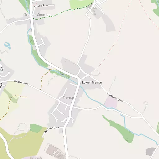
Tremar sits within Cornwall. Neighbouring places include Lower Tremar lying 92 m North, Tremar Coombe just 668 m North West, Rosecraddoc around 867 m South East and St Cleer just 979 m West. Other rural areas close to here include Gonamena, Trembraze, Hendrabridge, Redgate and Downgate.
You might discover something new by clicking a nearby place for more local details.
All place information is taken from OS, ONS and OSM under open licence.
⇅
Local Map
⇅
Location Summary
- Tremar is located in Cornwall
- Administrative Area: Cornwall
- Ceremonial County: Cornwall
- Historic County: Cornwall
- Region & Country: South West / England
⇅
Nearby Towns & Cities
- Liskeard 3.6 km S
- Callington 10.1 km E
- Looe 14.9 km S
- Lostwithiel 17.5 km WSW
- Plymouth 25.8 km ESE


⇅
Nearby Localities
- Lower TremarDistrict 92 m N
- Tremar CoombeDistrict 668 m NW
- RosecraddocVillage 867 m SE
- St CleerVillage 979 m W
- DariteVillage 1.2 km N
- Crow's NestVillage 1.3 km NNE
- Higher TremarcoombeVillage 1.5 km NNW
- Common MoorVillage 2.2 km WNW
- MerrymeetVillage 2.9 km SE
- AddingtonDistrict 3.0 km S


⇅
Smaller Settlements
- Gonamena 2.3 km N
- Trembraze 2.6 km S
- Hendrabridge 2.6 km SSE
- Redgate 3.1 km W
- Downgate 3.7 km NE
- Pengover Green 3.7 km SE
- Moorswater 4.5 km SSW
- Higher Stanbear 4.7 km N
- Caradon Town 4.7 km NE
- Upton 4.8 km NNE


⇅
Beaches
- Keveral Beach14.4 km SSE
- Millendreath Beach14.2 km S
- Plaidy Beach14.3 km S
⇅
Parks
- Lanner Moor60.5 km WSW
- Palm Cross Green43.0 km ESE
- Pleasure Grounds42.6 km NE
- Summerleaze Down38.9 km N
⇅
Woods
- Crossmans Hill Wood2.6 km SW
- Green Wood2.8 km SW
- Pickshill Wood558 m SE
- Rosecraddoc Wood825 m ESE

⇅
Hills
- Caradon Hill3.0 km NNE
- Sharp Tor5.5 km N
- Stowe's Hill4.3 km N
- Tregarrick Tor3.5 km NNW
⇅
Lakes
- Dozmary Pool9.0 km NW
- Ladies' Mile9.2 km N
- Siblyback Lake3.8 km NW
- Swan Pool9.1 km N
⇅
Waterfalls
- Golitha Falls3.5 km W
- White Lady Waterfall28.6 km NE
- Yealm Steps36.1 km E
⇅
Headlands
- Britain Point17.0 km SE
- Downend Point17.7 km S
⇅
Islands
- Erth Island16.5 km SE
- St George's Island16.7 km S
⇅
Wetlands
- Witheybrook Marsh4.6 km N
- Trewortha Marsh8.3 km NNW
- Tresellern Marsh8.3 km NNW
⇅
Health Services
- LaylandHospital 3.8 km SSW
- Launceston HospitalHospital 17.1 km NNE
- Liskeard Eventide HomeMedical 3.0 km S
- Hillcrest HouseMedical 13.9 km S
⇅
Education
- St Cleer Primary SchoolSchool 794 m W
- Darite Primary SchoolSchool 1.2 km N
- Peninsula Dental SchoolUniversity 24.2 km ESE
⇅
Railway Stations
- Liskeard4.6 km SSW
- Coombe Halt5.0 km SSW
⇅
Bus Stations
- Newquay Bus Station45.3 km W
- Truro Bus Station48.9 km WSW
⇅
Coach Stations
- Plymouth Coach Station25.6 km ESE
- Torquay Coach Station65.2 km E
⇅
Ferry Terminals
- Bodinnick20.5 km SW
- Caffa Mill Slipway20.6 km SW
⇅
Airports
- Plymouth City Airport25.6 km ESE
- Newquay Cornwall Airport39.9 km W
⇅
Airfields
- Bodmin Airfield14.9 km W
- Davidstow Airfield20.1 km NW
⇅
Heliports
- Cornwall Air Ambulance Station37.8 km W
- Hartland Heliport59.2 km N
⇅
Harbours
- Polperro Harbour17.9 km SSW
- Fowey Harbour21.3 km SW