
Trewellard
About Trewellard
Trewellard lies within Cornwall. Nearby places include Lower Trewellard situated 244 m West North West, Higher Boscaswell just 913 m North East, Pendeen just 936 m North East, Lower Boscaswell around 959 m North North East and Botallack only 1.3 km South South West. Other rural localities include Carnyorth, Boscean, Morvah and Higher Bosavern.
You might discover something new by clicking a nearby place for more local details.
The place data here is drawn from OS, ONS and OSM under open licence.
⇅
Local Map
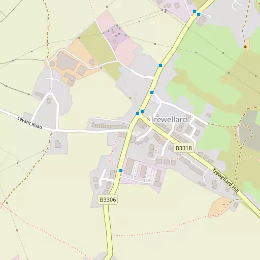
⇅
Location Summary
- Trewellard is located in Cornwall
- Administrative Area: Cornwall
- Ceremonial County: Cornwall
- Historic County: Cornwall
- Region & Country: South West / England
⇅
Nearby Towns & Cities


⇅
Nearby Localities
- Lower TrewellardDistrict 244 m WNW
- Higher BoscaswellDistrict 913 m NE
- PendeenVillage 936 m NE
- Lower BoscaswellDistrict 959 m NNE
- BotallackVillage 1.3 km SSW
- PortherrasDistrict 1.4 km ENE
- Higher BojewyanDistrict 1.8 km ENE
- TregesealVillage 1.9 km S
- NewbridgeVillage 5.2 km ESE
- Carn TowanVillage 7.2 km S


⇅
Smaller Settlements
- Carnyorth 494 m SSW
- Boscean 2.1 km SW
- Morvah 3.0 km NE
- Higher Bosavern 3.0 km S
- Bosorne 3.2 km SSW
- Bosavern 3.4 km S
- Trevowhan 3.7 km ENE
- Kelynack 3.7 km S
- Great Bosullow 3.8 km E
- Little Bosullow 4.1 km E

⇅
Beaches
- Gwynver6.4 km S
- Pednvounder Beach11.5 km S
- Sennen Cove Beach7.4 km SSW
⇅
Parks
- Lanner Moor34.9 km ENE
- Palm Cross Green128.8 km E
- Summerleaze Down110.5 km NE
- Trungle Moor10.7 km SE

⇅
Woods
- Bog Plantation13.4 km E
- Hellangove Plantation10.8 km E
- Price's Folly9.5 km ESE
- Tregavarah Downs7.0 km ESE
⇅
Hills
- Carn Clough2.6 km NNE
- Carn Gloose3.3 km SW
- Carn Vres1.9 km SE
- Wheal Bal Hill877 m SE
⇅
Lakes
- Boscathnoe Reservoir8.0 km ESE
- Drift Reservoir7.3 km SE
- Lidden2.3 km E
- South Lidden1.2 km ESE
⇅
Waterfalls
- Golitha Falls91.3 km ENE
- White Lady Waterfall122.6 km ENE
- Yealm Steps127.3 km ENE
⇅
Headlands
- Botallack Head1.4 km W
- Cape Cornwall3.2 km SW

⇅
Islands
- St Michael's Mount14.3 km ESE
- The Enys1.8 km N

⇅
Wetlands
- Merthen Point11.8 km SSE
- Cradles12.0 km S
- Pol Ledan12.1 km S

⇅
Health Services
- West Cornwall HospitalHospital 9.7 km ESE
- PengarthHospital 10.2 km ESE
- Benoni Nursing HomeMedical 2.8 km S
- Trevaylor Manor Nursing HomeMedical 9.3 km E
⇅
Education
- Pendeen SchoolSchool 840 m NE
- Cape Cornwall SchoolSchool 2.4 km SSW
- Cornwall College of Further and Higher EducationUniversity 29.7 km ENE
⇅
Railway Stations
- Penzance10.5 km ESE
- St Ives15.7 km ENE
⇅
Bus Stations
- Penzance Bus Station10.5 km ESE
- St Ives15.7 km ENE
⇅
Coach Stations
- Plymouth Coach Station111.6 km ENE
- Torquay Coach Station156.1 km ENE
⇅
Ferry Terminals
- Penzance Ferry Terminal10.8 km ESE
- Trelissick46.6 km E
⇅
Airports
- Land's End Airport4.8 km S
- St Mary's Airport51.2 km WSW

⇅
Airfields
- Royal Navy Air Station Culdrose31.0 km ESE
- Predannack Airfield35.4 km ESE
⇅
Heliports
- Penzance Heliport11.6 km E
- Cornwall Air Ambulance Station58.5 km ENE
⇅
Harbours
- Newlyn Harbour10.3 km ESE
- Mousehole Harbour11.9 km SE