
Walton Court, Aylesbury
About Walton Court
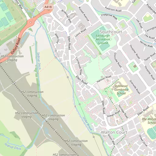
Walton Court is 585 m ENE from Aylesbury in the county of Buckinghamshire. Local places nearby include Southcourt lying 585 m East North East, California lying 1.4 km North North East, Lower Hartwell situated 1.7 km West North West, Walton just 1.8 km North East and Bishopstone lying 1.9 km South South West. Other settlements close by include Sedrup, Marsh, North Lee and Broughton Crossing.
You may notice something interesting if you explore one of the nearby places.
The place data here is drawn from OS, ONS and OSM under open licence.
⇅
Local Map
⇅
Location Summary
- Walton Court is a neighbourhood in Aylesbury
- Administrative Area: Buckinghamshire
- Ceremonial County: Buckinghamshire
- Historic County: Buckinghamshire
- Region & Country: South East / England
⇅
Nearby Towns & Cities
- Parent town: Aylesbury
- Aylesbury 1.9 km NNE
- Wendover 7.2 km SE
- Princes Risborough 8.7 km S
- Tring 11.3 km E
- Milton Keynes 27.2 km N


⇅
Nearby Localities
- SouthcourtDistrict 585 m ENE
- CaliforniaDistrict 1.4 km NNE
- Lower HartwellDistrict 1.7 km WNW
- WaltonDistrict 1.8 km NE
- BishopstoneVillage 1.9 km SSW
- StoneVillage 2.1 km W
- Upper HartwellDistrict 2.4 km W
- Victoria ParkDistrict 2.6 km NE
- Manor ParkDistrict 2.7 km NNE
- Haydon HillDistrict 2.7 km NNW


⇅
Smaller Settlements
- Sedrup 1.3 km WSW
- Marsh 3.1 km S
- North Lee 3.4 km SSE
- Broughton Crossing 3.8 km NE
- Kimble Wick 4.5 km S
- Nash Lee 4.9 km SE
- Gibraltar 5.4 km WSW
- Chalkshire 5.5 km SSE
- Fleet Marston 5.6 km NW
- World's End 5.7 km ESE


⇅
Beaches
- Bell Wharf Beach106.1 km ESE
- Cotswold Hills Beach79.7 km W
- Hadleigh Ray102.2 km ESE
⇅
Parks
- Balderson's Moor25.0 km ESE
- Chaulden Meadow23.3 km ESE
- Elfield Park24.4 km N
- Merton Field29.8 km W
⇅
Woods
- Arthur's Gorse3.2 km WNW
- Beech Walk1.4 km W
- Rifle Spinney1.4 km WNW
- The Grove1.6 km W
⇅
Hills
- Burn Hill3.3 km WNW
- Dial Hill6.4 km SSE
- Park Hill1.4 km WNW
- Waddesdon Hill6.1 km WNW
⇅
Lakes
- Biggin Pond4.6 km WSW
- Mill Pond5.5 km SSE
- Oakfield Lake4.1 km ENE
- Weston Turville Reservoir5.6 km ESE
⇅
Waterfalls
- Neptune Waterfall23.2 km SE
- The Cascade28.1 km NNW
- Tower Waterfall22.4 km SE
⇅
Headlands
- Botany Bay Point46.3 km SSE
- Tripcock Ness71.2 km ESE
⇅
Islands
- China Island13.9 km WNW
- Grotto Island13.9 km WNW
⇅
Wetlands
- Cock Marsh26.4 km SSE
- Wargrave Marsh32.3 km S
- Ickenham Marsh38.6 km SE
⇅
Health Services
- Stoke Mandeville HospitalHospital 1.8 km ESE
- The International Spinal Injuries and Rehabilitation CentreHospital 2.1 km NNE
- The Gables Nursing HomeMedical 1.8 km ENE
- Byron HouseMedical 1.8 km ENE
⇅
Education
- Ashmead Combined SchoolSchool 483 m ESE
- The Mandeville SchoolSchool 955 m ESE
- Buckinghamshire New UniversityUniversity 1.7 km NE
⇅
Railway Stations
- Aylesbury1.5 km NE
- Stoke Mandeville3.4 km ESE
⇅
Bus Stations
- Aylesbury Bus Station1.6 km NNE
- High Wycombe Bus Station19.6 km SSE
⇅
Coach Stations
- High Wycombe Coachway21.4 km SSE
- Milton Keynes Coachway29.4 km NNE
⇅
Ferry Terminals
- Hammerton's Pier53.0 km SE
- Hampton Ferry Boathouse53.9 km SE
⇅
Airports
- Wycombe Air Park21.5 km S
- London Luton Airport32.7 km ENE
⇅
Airfields
- Halton Airfield6.2 km ESE
- Holmbeck Farm Airfield13.7 km NNE
⇅
Heliports
- The London Heliport58.0 km SE
- Magpas Air Ambulance75.1 km NNE
⇅
Harbours
- Chelsea Harbour57.5 km SE
- Hendy's Quay106.9 km S