
Weston Green
About Weston Green
Weston Green, in Cambridgeshire, has Weston Colville only 1.3 km North West, Carlton just 1.7 km East North East, West Wratting lying 2.2 km West, Brinkley lying 2.5 km North and West Wickham only 2.9 km South South West. Other rural settlements include Carlton Green, Willingham Green, Temple End and Streetly End.
You might learn something new by clicking through to a nearby place.
Information is sourced from OS, ONS and OSM under open licence, using publicly available datasets.
⇅
Local Map
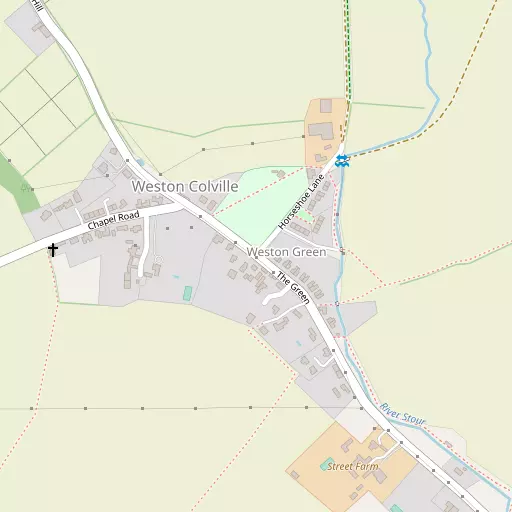
⇅
Location Summary
- Weston Green is located in Cambridgeshire
- Administrative Area: Cambridgeshire
- Ceremonial County: Cambridgeshire
- Historic County: Cambridgeshire
- Region & Country: Eastern / England
⇅
Nearby Towns & Cities
- Haverhill 8.0 km SSE
- Newmarket 11.2 km N
- Clare 15.8 km ESE
- Saffron Walden 16.3 km SW
- Cambridge 18.7 km WNW


⇅
Nearby Localities
- Weston ColvilleVillage 1.3 km NW
- CarltonVillage 1.7 km ENE
- West WrattingVillage 2.2 km W
- BrinkleyVillage 2.5 km N
- West WickhamVillage 2.9 km SSW
- Burrough GreenVillage 3.5 km NNE
- Burrough EndVillage 3.8 km N
- Westley WaterlessVillage 3.9 km N
- Great Bradley Village 4.2 km E
- BalshamVillage 4.3 km WSW


⇅
Smaller Settlements
- Carlton Green 1.6 km ESE
- Willingham Green 1.7 km N
- Temple End 3.7 km ESE
- Streetly End 4.3 km SSW
- Dullingham Ley 4.5 km NNE
- Lark Hall Corner 4.7 km WNW
- Little Thurlow 5.1 km ESE
- Cross Green 5.4 km NNE
- Little Bradley 5.5 km E
- Cardinal's Green 5.9 km S

⇅
Other places with this name
- Weston Green, Norfolk 78.4 km NE
- Weston Green, Surrey 98.0 km SSW

⇅
Beaches
- Brightlingsea Beach57.6 km SE
- Mill Beach51.6 km SSE
- West Mersea Beach55.7 km SE

⇅
Parks
- Butt Green18.3 km WNW
- Cole Green19.2 km ESE
- Empty Common17.8 km WNW
- Risbridge Meadow9.2 km SE
⇅
Woods
- Hill Crofts869 m WNW
- Horse Pastures831 m N
- Lower Wood653 m NNW
- Whiting's Grove710 m ESE

⇅
Hills
- Bedham Hill6.3 km NNW
- Cambridge Hill5.4 km NNW
- Chilly Hill4.9 km NW
- Jarvis Hill5.5 km SE
⇅
Lakes
- Acre Pond4.8 km S
- Horseheath Pond4.8 km NNE
- Punchbowl Pond4.9 km N
- Todd's Pond6.0 km N
⇅
Waterfalls
- Neptune Waterfall82.4 km SW
- The Cascade96.0 km W
- Tower Waterfall82.6 km SW
⇅
Headlands
- Tripcock Ness73.3 km SSW
- West Point74.8 km S
⇅
Islands
- Duck Island17.8 km SW
- The Island4.0 km ESE
⇅
Wetlands
- The Marsh12.5 km N
- Chesterton Fen17.1 km WNW
- Fowlmere22.9 km WSW
⇅
Health Services
- Newmarket HospitalHospital 12.0 km N
- Ida Darwin HospitalHospital 12.6 km WNW
- The MeadowsMedical 6.6 km SSE
- Cleves Place Care HomeMedical 8.0 km SE
⇅
Education
- Burrough Green Church of England Primary SchoolSchool 3.5 km NNE
- Meadow Primary SchoolSchool 4.1 km WSW
- Strangeways Research LaboratoryUniversity 15.8 km WNW
⇅
Railway Stations
- Dullingham6.4 km N
- Newmarket10.6 km NNE
⇅
Bus Stations
- Haverhill Bus Station8.2 km SSE
- Addenbrooke's Bus Station16.2 km WNW
⇅
Coach Stations
- Stansted Airport Coach Station29.4 km SSW
- Luton Airport Bus and Coach Station59.3 km WSW
⇅
Ferry Terminals
- Harwich Ferry Port63.7 km ESE
- Burnham Ferry65.3 km SSE
⇅
Airports
- Cambridge City Airport15.2 km WNW
- Stansted Airport30.0 km SSW
⇅
Airfields
- Ridgewell Airfield16.3 km SE
- Duxford Airfield17.8 km WSW
⇅
Heliports
- The Egerton-Smith Centre15.6 km WNW
- Magpas Air Ambulance49.8 km WNW
⇅
Harbours
- Harwich Harbour66.2 km ESE
- Chelsea Harbour83.7 km SSW