
Wimpole
About Wimpole
Wimpole is in Cambridgeshire. Local places nearby include Orwell around 1.5 km East North East, Arrington only 2.1 km West, Croydon lying 3.2 km West, Whaddon around 3.8 km South and Great Eversden lying 4.0 km North North East. Other places in the surrounding countryside include Old Wimpole, Wendy, Dyer's Green and Shingay.
You may find out something new or interesting if you click a nearby place to see more local information.
These details are compiled from OS, ONS and OSM data released under open licence.
⇅
Local Map
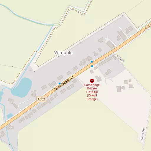
⇅
Location Summary
- Wimpole is located in Cambridgeshire
- Administrative Area: Cambridgeshire
- Ceremonial County: Cambridgeshire
- Historic County: Cambridgeshire
- Region & Country: Eastern / England
⇅
Nearby Towns & Cities
- Royston 9.2 km S
- Potton 12.4 km W
- Biggleswade 16.5 km WSW
- Sandy 17.5 km W
- Cambridge 13.2 km NE


⇅
Nearby Localities
- OrwellVillage 1.5 km ENE
- ArringtonVillage 2.1 km W
- CroydonVillage 3.2 km W
- WhaddonVillage 3.8 km S
- Great EversdenVillage 4.0 km NNE
- Little EversdenVillage 4.1 km NE
- MeldrethVillage 4.4 km SE
- BarringtonVillage 4.6 km E
- HarltonVillage 4.6 km ENE
- SheprethVillage 4.8 km ESE


⇅
Smaller Settlements
- Old Wimpole 1.6 km NNW
- Wendy 3.3 km SW
- Dyer's Green 4.4 km S
- Shingay 5.2 km SW
- North Brook End 7.9 km SW
- Great Green 8.3 km SW
- Little Green 8.4 km SW
- Cockayne Hatley 8.8 km W
- Flint Cross 8.8 km SE
- Morden Green 9.2 km SW


⇅
Beaches
- Hadleigh Ray78.7 km SSE
- Mill Beach68.2 km SE
- West Mersea Beach76.5 km ESE

⇅
Parks
- Butt Green13.9 km NE
- Empty Common12.7 km ENE
- Reed Green13.7 km S
- Wimpole Park2.1 km NW

⇅
Woods
- Cobb's Wood1.6 km N
- Four Acre Covert754 m WNW
- Sharp Hill Plantation2.2 km NNE
- Victoria Plantation1.3 km NNE


⇅
Hills
- Edics Hill2.4 km E
- Lamp Hill1.1 km NW
- Thornberry Hill1.2 km N
- Toot Hill2.0 km ENE
⇅
Lakes
- Hauxton Junction9.1 km ENE
- Johnston's Pond2.5 km NNW
- Long's Lake4.2 km SW
- My Lady's Pond1.2 km WNW
⇅
Waterfalls
- Neptune Waterfall61.9 km SW
- The Cascade68.2 km W
- Tower Waterfall62.0 km SW
⇅
Headlands
- Tripcock Ness69.7 km S
- West Point83.5 km SSE
⇅
Islands
- Duck Island21.2 km SE
- Riddy Island8.9 km ENE
⇅
Wetlands
- Fowlmere7.4 km SE
- Chesterton Fen17.5 km NE
- Ouse Fen23.2 km N
⇅
Health Services
- Kneesworth House HospitalHospital 5.8 km S
- Royston HospitalHospital 10.0 km S
- Maycroft Care HomeMedical 4.5 km SE
- St George's Nursing HomeMedical 8.8 km S
⇅
Education
- Petersfield Church of England (Aided) Primary SchoolSchool 1.0 km E
- Meldreth Manor SchoolSchool 4.4 km SE
- Madingley HallUniversity 11.4 km NNE
⇅
Railway Stations
- Shepreth4.7 km ESE
- Meldreth5.3 km SSE
⇅
Bus Stations
- Royston Bus Station9.5 km S
- Addenbrooke's Bus Station13.1 km ENE
⇅
Coach Stations
- Stansted Airport Coach Station33.7 km SE
- Luton Airport Bus and Coach Station36.6 km SW
⇅
Ferry Terminals
- Blackfriars Pier69.1 km S
- Bankside Pier69.3 km S
⇅
Airports
- Cambridge City Airport16.3 km ENE
- Stansted Airport33.1 km SE
⇅
Airfields
- Top Farm Airfield5.9 km W
- Little Grandsden Airfield8.9 km WNW
⇅
Heliports
- The Egerton-Smith Centre16.2 km ENE
- Magpas Air Ambulance31.2 km NNW
⇅
Harbours
- Chelsea Harbour73.6 km S
- Harwich Harbour92.8 km ESE