
Winsham
About Winsham
Winsham is in Somerset. Local places nearby include Holway only 2.9 km South South East, Thorncombe situated 3.1 km South, Wayford lying 3.3 km East and Townsend situated 3.4 km East. Other rural localities include Ammerham, Whatley, Cricket St Thomas, Laymore and Street.
You might discover something new by clicking a nearby place for more local details.
Information is sourced from OS, ONS and OSM under open licence, using publicly available datasets.
⇅
Local Map
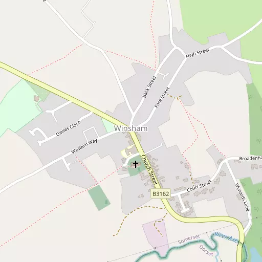
⇅
Location Summary
- Winsham is located in Somerset
- Administrative Area: Somerset
- Ceremonial County: Somerset
- Historic County: Somerset
- Region & Country: South West / England
⇅
Nearby Towns & Cities


⇅
Nearby Localities
- Holway District 2.9 km SSE
- Thorncombe Village 3.1 km S
- WayfordVillage 3.3 km E
- TownsendDistrict 3.4 km E
- Chard JunctionDistrict 3.6 km WSW
- Axeford EstateDistrict 3.7 km WSW
- CoombsesDistrict 3.9 km W
- FortonVillage 3.9 km W
- ClaptonVillage 3.9 km E
- Perry StreetDistrict 4.2 km WSW


⇅
Smaller Settlements
- Ammerham 939 m WSW
- Whatley 1.4 km WNW
- Cricket St Thomas 2.1 km N
- Laymore 2.1 km SE
- Street 2.4 km WNW
- Lydmarsh 3.1 km NW
- Purtington 3.2 km NNE
- Greenham 3.7 km ESE
- Woolminstone 4.0 km ENE
- School House 4.0 km S


⇅
Beaches
- Charmouth Beach13.4 km S
- Cobb Gate Beach14.8 km SSW
- Front Beach15.0 km SSW

⇅
Parks
- Pennsylvania Park46.2 km WSW
- The Lawn50.8 km SW
- Worle Moor56.0 km N
- Yargrass Green43.0 km NNE
⇅
Woods
- Baymore Coppice1.1 km S
- Brockclose Covert1.1 km W
- Cookshill Plantation919 m N
- Grove Coppice754 m S
⇅
Hills
- Blackdown Hill3.3 km SE
- Hazelwood Hill473 m NW
- Knoll Hill2.6 km N
- Staker's Cross Hill2.9 km ENE
⇅
Lakes
- Chard Reservoir5.0 km NW
- Great Pond2.1 km SW
- Mermaid Pond2.1 km SW
- Spring Bottom5.8 km NE

⇅
Waterfalls
- Becka Falls66.6 km WSW
- Broad Falls82.0 km WSW
- Horseshoe Falls75.3 km WSW
⇅
Headlands
- Brandy Head36.7 km SW
- Otterton Point38.3 km SW
⇅
Islands
- Fenning Island41.4 km NNW
- Fish's Island41.2 km E
⇅
Wetlands
- Farway Marsh7.2 km WSW
- Champernhayes Marsh9.8 km SSW
- Cockpits13.7 km S
⇅
Health Services
- Chard and District Community HospitalHospital 5.0 km WNW
- Crewkerne HospitalHospital 7.1 km ENE
- Oak LodgeMedical 5.0 km WNW
- The OrchardsMedical 7.6 km ENE
⇅
Education
- Winsham Primary SchoolSchool 147 m SW
- St Mary's Church of England (Voluntary Controlled) Primary SchoolSchool 2.9 km S
- Architectural Association Hooke ParkUniversity 16.7 km ESE
⇅
Railway Stations
- Crewkerne8.1 km ENE
- Axminster11.6 km SW
⇅
Bus Stations
- Taunton Bus Station23.5 km NW
- Exeter Bus Station46.8 km WSW
⇅
Coach Stations
- Torquay Coach Station62.1 km SW
- Millstream Coach Park80.3 km ENE
⇅
Ferry Terminals
- Starcross Pier46.5 km WSW
- Brownsea Island Ferry65.5 km ESE
⇅
Airports
- Exeter Airport39.0 km WSW
- Bristol Airport60.1 km NNE
⇅
Airfields
- Royal Navy Air Station Merryfield12.8 km NNW
- Watchford Farm15.5 km WNW
⇅
Heliports
- Cardiff City Heliport70.4 km NNW
- Lake Heliport97.5 km WNW
⇅
Harbours
- Bridport Harbour18.2 km SSE
- Portland Harbour43.4 km SE