
Wookey
About Wookey
Wookey sits within Somerset. Places nearby include Haybridge situated 1.6 km East, Easton just 2.0 km North North West, Coxley Wick only 2.1 km South South East, Wookey Hole situated 2.1 km North East and Henton around 2.5 km West. Other countryside settlements include Henley, Worth, Burcott and Yarley.
You may find extra local information by clicking a nearby place.
The details shown here use OS, ONS and OSM data provided under open licence.
⇅
Local Map
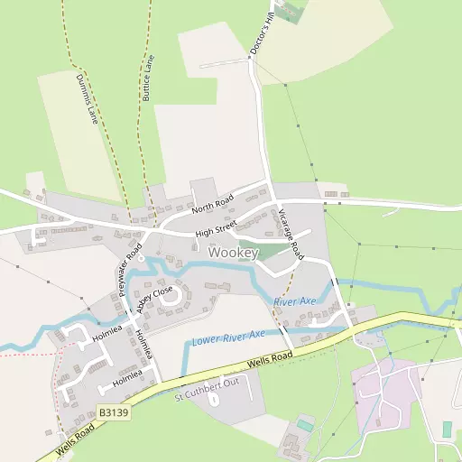
⇅
Location Summary
- Wookey is located in Somerset
- Administrative Area: Somerset
- Ceremonial County: Somerset
- Historic County: Somerset
- Region & Country: South West / England
⇅
Nearby Towns & Cities
- Glastonbury 7.2 km SSW
- Street 9.8 km SSW
- Shepton Mallet 10.3 km ESE
- Axbridge 12.3 km NW
- Wells 3.1 km E


⇅
Nearby Localities
- HaybridgeVillage 1.6 km E
- EastonVillage 2.0 km NNW
- Coxley WickVillage 2.1 km SSE
- Wookey HoleVillage 2.1 km NE
- HentonVillage 2.5 km W
- Upper CoxleyVillage 2.6 km SE
- CoxleyVillage 2.7 km SSE
- St AndrewDistrict 3.4 km E
- Westbury-sub-MendipVillage 3.5 km NNW
- DulcoteVillage 4.8 km ESE


⇅
Smaller Settlements
- Henley 930 m ENE
- Worth 1.1 km SW
- Burcott 1.1 km ESE
- Yarley 1.7 km WSW
- Fenny Castle 2.1 km SSW
- Lower Milton 2.7 km NE
- Holly Brook 2.8 km NNW
- Woodford 2.9 km SE
- Polsham 3.1 km S
- Bleadney 3.3 km W


⇅
Beaches
- Berrow Beach25.2 km WNW
- Burnham-on-Sea Beach22.7 km WNW
- Royal Sands and Uphill25.0 km WNW

⇅
Parks
- Clifton Down28.9 km N
- Lower Common29.5 km NE
- Worle Moor23.2 km NW
- Yargrass Green1.6 km ENE

⇅
Woods
- Ben Knowle Wood578 m S
- Hembury Wood1.6 km SW
- Under Wood2.4 km ENE
- Wattles Wood2.0 km NNE

⇅
Hills
- Ben Knowle Hill974 m S
- Hay Hill1.6 km SE
- Hembury Hill1.6 km SW
- Henley Hill798 m ENE
⇅
Lakes
- Brimble Pit Pool5.1 km NNW
- Mineries Pool5.6 km NNE
- Priddy Pool6.0 km N
- Waldegrave Pool6.3 km NNE
⇅
Waterfalls
- Berw-ddu78.9 km NW
- Llech Sychryd80.8 km NW
- Pwll Annie78.9 km NW
⇅
Headlands
- Battery Point32.2 km N
- Stert Point23.1 km W
⇅
Islands
- Denny Island15.8 km NNE
- Stert Island22.9 km W
⇅
Wetlands
- Hollow Marsh14.5 km NE
- The Cut22.0 km WSW
- Pawlett Gore Sands23.0 km W
⇅
Health Services
- Priory Health ParkHospital 2.6 km ESE
- West Mendip Community HospitalHospital 5.5 km S
- Wells Nursing HomeMedical 2.4 km W
- Glastonbury Care HomeMedical 7.3 km SSW
⇅
Education
- Wookey Primary SchoolSchool 821 m SW
- St Cuthbert's Church of England AcademySchool 2.4 km ESE
- University of BristolUniversity 16.2 km NNW
⇅
Railway Stations
- Mendip Vale12.4 km ESE
- Merryfield Lane13.8 km ESE
⇅
Bus Stations
- Cribbs Causeway Bus Station35.9 km N
- Taunton Bus Station36.1 km SW
⇅
Coach Stations
- Millstream Coach Park64.2 km ESE
- Southampton Coach Station95.7 km ESE
⇅
Ferry Terminals
- SS Great Britain Ferry Landing27.2 km NNE
- Harbour Inlet Ferry Landing27.3 km NNE
⇅
Airports
- Bristol Airport19.4 km N
- Cardiff Airport50.2 km WNW
⇅
Airfields
- Halesland Airfield6.7 km NNW
- Clutton Hill Airfield18.8 km NE
⇅
Heliports
- Cardiff City Heliport42.3 km NW
- Lake Heliport110.7 km W
⇅
Harbours
- Mud Dock27.4 km NNE
- Floating Harbour27.7 km NNE