
Yarde
About Yarde
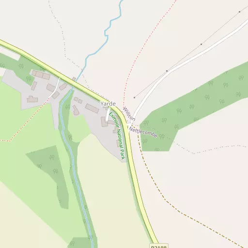
Yarde, in Somerset, has Monksilver situated 2.0 km South East, Washford just 2.5 km North West, Roadwater lying 2.5 km West, Williton around 2.5 km North East and Sampford Brett around 2.8 km East North East. Other rural communities nearby include Woodford, Stream, Nettlecombe and Beggearn Huish.
You may notice something interesting if you explore one of the nearby places.
This information is based on OS, ONS and OSM data released under open licence.
⇅
Local Map
⇅
Location Summary
- Yarde is located in Somerset
- Administrative Area: Somerset
- Ceremonial County: Somerset
- Historic County: Somerset
- Region & Country: South West / England
⇅
Nearby Towns & Cities
- Watchet 4.4 km NNE
- Wiveliscombe 11.4 km S
- Minehead 11.6 km NW
- Dulverton 18.4 km SW
- Cardiff 39.2 km NNE


⇅
Nearby Localities
- MonksilverVillage 2.0 km SE
- WashfordVillage 2.5 km NW
- RoadwaterVillage 2.5 km W
- WillitonVillage 2.5 km NE
- Sampford BrettVillage 2.8 km ENE
- BilbrookVillage 3.0 km NW
- St DecumansDistrict 3.6 km N
- Old CleeveVillage 3.6 km NW
- StogumberVillage 4.1 km ESE
- Chapel CleeveVillage 4.5 km NNW


⇅
Smaller Settlements
- Woodford 741 m SSE
- Stream 848 m NE
- Nettlecombe 1.3 km SSW
- Beggearn Huish 1.7 km WNW
- Torre 1.7 km WNW
- Capton 1.9 km ENE
- Hungerford 1.9 km NW
- Chidgley 3.0 km SSW
- Escott 3.2 km ESE
- Sticklepath 3.3 km SSW


⇅
Beaches
- Blue Anchor Beach6.3 km NW
- Dunster Beach8.3 km NW
- West Street Beach4.6 km N
⇅
Parks
- Castle Green39.4 km NNE
- Cooper's Fields39.5 km NNE
- Splott Park40.4 km NNE
- Worle Moor37.4 km NE
⇅
Woods
- Housepiece Copse374 m S
- Quarry Hill Copse780 m SE
- Yarde Alders500 m WNW
- Yarde Copse146 m ENE
⇅
Hills
- Bird's Hill2.8 km S
- Claydowns Hill3.0 km NW
- Kings Wood Hill2.6 km SW
- North Bird's Hill2.7 km SSE
⇅
Lakes
- Hill Head Pond1.9 km NNW
- Island Pond941 m S
- Parsonage Pond1.7 km SSW
- The Swill4.8 km NE
⇅
Waterfalls
- Becka Falls66.1 km SSW
- Berw-ddu63.7 km N
- Melin Court Waterfall66.8 km NNW
⇅
Headlands
- Blue Ben7.8 km NE
- Hurlstone Point19.0 km WNW
⇅
Islands
- Fenning Island23.8 km ENE
- Stert Island24.8 km ENE
⇅
Wetlands
- Swill Point5.9 km NE
- Kermoor Piling6.7 km NW
- New Marsh8.4 km SE
⇅
Health Services
- Williton HospitalHospital 2.6 km NNE
- Minehead Community HospitalHospital 10.3 km NW
- Winsor Nursing HomeMedical 11.3 km NW
- Wey HouseMedical 17.7 km SE
⇅
Education
- Old Cleeve Church of England SchoolSchool 2.6 km NNW
- Danesfield Church of England Middle SchoolSchool 2.9 km NNE
- Weston College South West Skills CampusUniversity 35.9 km NE
⇅
Railway Stations
- Washford2.7 km NW
- Williton3.5 km NE
⇅
Bus Stations
- Taunton Bus Station21.9 km SE
- Cardiff Bus Interchange38.8 km NNE
⇅
Coach Stations
- Torquay Coach Station75.6 km S
- Plymouth Coach Station102.5 km SSW
⇅
Ferry Terminals
- Newport Transporter Bridge West53.6 km NNE
- Newport Transporter Bridge East53.6 km NNE
⇅
Airports
- Cardiff Airport28.4 km N
- Exeter Airport45.7 km S
⇅
Airfields
- Maes Awyr Sain Tathan30.0 km NNW
- Westonzoyland30.5 km E

⇅
Heliports
- Cardiff City Heliport38.8 km NNE
- Lake Heliport64.6 km W
⇅
Harbours
- Watchet Harbour4.5 km NNE
- Lynmouth Harbour35.3 km WNW