
Yardley Gobion
About Yardley Gobion
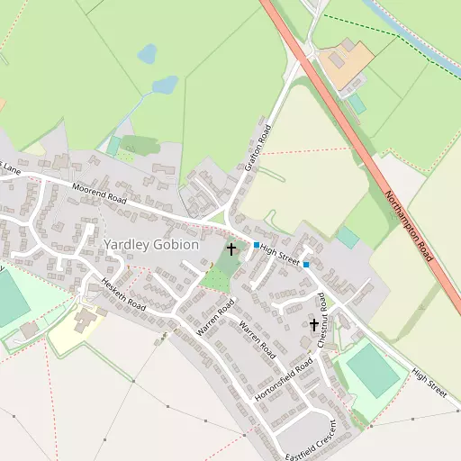
Yardley Gobion, in West Northamptonshire, has Potterspury just 1.7 km South South West, Grafton Regis only 2.0 km North North West, Alderton just 3.1 km North West, Castlethorpe situated 3.3 km East and Cosgrove lying 3.4 km South East. Other countryside places nearby include Moor End, Passenham, Tathall End and Heathencote.
You may find extra local information by clicking a nearby place.
All place information is taken from OS, ONS and OSM under open licence.
⇅
Local Map
⇅
Location Summary
- Yardley Gobion is located in West Northamptonshire
- Administrative Area: West Northamptonshire
- Ceremonial County: West Northamptonshire
- Historic County: West Northamptonshire
- Region & Country: East Midlands / England
⇅
Nearby Towns & Cities
- Towcester 8.1 km WNW
- Newport Pagnell 11.1 km E
- Buckingham 12.7 km SSW
- Olney 14.2 km ENE
- Milton Keynes 10.7 km ESE


⇅
Nearby Localities
- PotterspuryVillage 1.7 km SSW
- Grafton RegisVillage 2.0 km NNW
- AldertonVillage 3.1 km NW
- Castlethorpe Village 3.3 km E
- CosgroveVillage 3.4 km SE
- Old StratfordVillage 3.9 km SSE
- Church End District 4.2 km ENE
- Long Street Village 4.3 km NE
- PaulerspuryVillage 4.4 km W
- Hanslope Village 4.4 km ENE


⇅
Smaller Settlements
- Moor End 921 m W
- Passenham 5.5 km SSE
- Tathall End 5.9 km ENE
- Heathencote 6.1 km WNW
- Wood Burcote 7.4 km WNW
- Little Linford 7.8 km E
- Hulcote 7.9 km NW
- Lillingstone Dayrell 8.4 km SW
- Quinton Green 8.4 km NNE
- Gayhurst 8.7 km E


⇅
Beaches
- Cotswold Hills Beach88.2 km WSW
- Hadleigh Ray119.0 km ESE
- Mill Beach117.6 km ESE

⇅
Parks
- Elfield Park12.2 km SE
- Foot Meadow15.6 km N
- The Green9.4 km ESE
- The Green16.0 km NNW

⇅
Woods
- Ash Pole Spinney2.7 km SSE
- East Waterslade Copse2.4 km WSW
- Fiery Furze1.3 km NNE
- Oakley Spinney2.3 km WSW
⇅
Hills
- Blisworth Hill8.0 km NNW
- Cuckoos' Hill3.6 km ENE
- Organ's Hill7.0 km NE
- Windmill Hill8.5 km NW
⇅
Lakes
- Bradlem Pond3.2 km W
- Broad Water4.3 km SE
- Old Stratford Cut3.8 km SE
- The Longwater6.9 km NW
⇅
Waterfalls
- Neptune Waterfall51.7 km SSE
- The Cascade11.8 km SW
- Tower Waterfall51.1 km SSE
⇅
Headlands
- Botany Bay Point78.7 km SSE
- Tripcock Ness93.6 km SE
⇅
Islands
- Millholme Island20.8 km ENE
- Monkey Island11.6 km SW
⇅
Wetlands
- Summer Leys22.3 km NNE
- Welches Meadow48.5 km WNW
- Ranger's Marsh49.1 km WSW
⇅
Health Services
- Buckingham HospitalHospital 12.5 km SSW
- Milton Keynes University HospitalHospital 12.7 km SE
- The ManorMedical 2.2 km NNW
- Brook HouseMedical 8.2 km WNW
⇅
Education
- Yardley Gobion Church of England Primary SchoolSchool 365 m WSW
- John Hellins Primary SchoolSchool 1.8 km SSW
- Verney Park CampusUniversity 13.1 km SSW
⇅
Railway Stations
- Wolverton6.4 km ESE
- Milton Keynes Central10.2 km SE
⇅
Bus Stations
- Bletchley Bus Station15.2 km SE
- North Gate Bus Station15.9 km N
⇅
Coach Stations
- Milton Keynes Coachway13.4 km ESE
- Luton Airport Bus and Coach Station42.4 km SE
⇅
Ferry Terminals
- Normanton Chain Ferry81.8 km NNW
- Hammerton's Pier82.2 km SSE
⇅
Airports
- London Oxford Airport41.5 km SW
- London Luton Airport43.1 km SE
⇅
Airfields
- Turweston Aerodrome16.0 km WSW
- Cranfield Airport18.4 km E
⇅
Heliports
- Magpas Air Ambulance53.4 km NE
- The Egerton-Smith Centre73.1 km E
⇅
Harbours
- Chelsea Harbour84.3 km SE
- Farndon Harbour107.6 km N