
Aston Clinton
About Aston Clinton
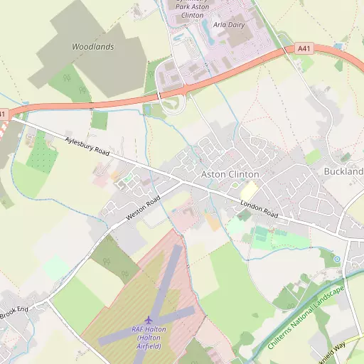
Aston Clinton lies within Buckinghamshire. Places nearby include Buckland just 1.4 km East, Brook End lying 1.7 km South West, Bucklandwharf lying 2.0 km East South East, Church End situated 2.2 km South West and Weston Turville lying 2.3 km South West. Other rural communities nearby include Puttenham, World's End, Astrope and Wilstone Green.
You might discover something new by clicking a nearby place for more local details.
The details shown here use OS, ONS and OSM data provided under open licence.
⇅
Local Map
⇅
Location Summary
- Aston Clinton is located in Buckinghamshire
- Administrative Area: Buckinghamshire
- Ceremonial County: Buckinghamshire
- Historic County: Buckinghamshire
- Region & Country: South East / England
⇅
Nearby Towns & Cities
- Wendover 4.4 km S
- Tring 5.0 km E
- Aylesbury 5.6 km WNW
- Princes Risborough 11.0 km SW
- Milton Keynes 26.8 km N


⇅
Nearby Localities
- BucklandVillage 1.4 km E
- Brook EndDistrict 1.7 km SW
- BucklandwharfDistrict 2.0 km ESE
- Church EndDistrict 2.2 km SW
- Weston TurvilleVillage 2.3 km SW
- HaltonVillage 2.5 km S
- West EndDistrict 2.6 km SW
- Drayton BeauchampVillage 2.8 km E
- BroughtonVillage 3.3 km WNW
- BedgroveDistrict 3.5 km W


⇅
Smaller Settlements
- Puttenham 2.8 km NNE
- World's End 3.4 km SSW
- Astrope 3.4 km NE
- Wilstone Green 3.5 km ENE
- Gubblecote 4.2 km NE
- Broughton Crossing 4.2 km NW
- Little Tring 4.3 km E
- West Leith 4.3 km ESE
- Tringford 4.5 km ENE
- Hulcott 5.0 km NNW


⇅
Beaches
- Bell Wharf Beach100.0 km ESE
- Cotswold Hills Beach85.9 km W
- Hadleigh Ray96.1 km ESE
⇅
Parks
- Balderson's Moor18.9 km ESE
- Chaulden Meadow17.2 km ESE
- Elfield Park24.1 km N
- Seabrook Meadow26.3 km ESE
⇅
Woods
- Engine House Belt2.1 km S
- Marl Copse1.8 km SSE
- Rosemead Covert1.6 km S
- Splash Covert833 m SW

⇅
Hills
- Boddington Hill4.3 km S
- Coombe Hill2.8 km SE
- Haddington Hill3.6 km SSE
- Wood Hill2.5 km ESE

⇅
Lakes
- Oakfield Lake3.6 km NW
- Tringford Reservoir4.6 km ENE
- Weston Turville Reservoir2.9 km SSW
- Wilstone Reservoir3.2 km ENE
⇅
Waterfalls
- Neptune Waterfall18.4 km SE
- The Cascade31.6 km NW
- Tower Waterfall17.7 km SE
⇅
Headlands
- Botany Bay Point44.4 km SSE
- Tripcock Ness65.6 km ESE
⇅
Islands
- China Island20.1 km WNW
- Grotto Island20.0 km WNW
⇅
Wetlands
- Cock Marsh25.4 km S
- Wargrave Marsh33.5 km SSW
- Ickenham Marsh34.4 km SE
⇅
Health Services
- Stoke Mandeville HospitalHospital 4.7 km W
- The Whiteleaf CentreHospital 5.2 km WNW
- Byron HouseMedical 4.6 km W
- The Gables Nursing HomeMedical 4.7 km W
⇅
Education
- Aston Clinton SchoolSchool 554 m E
- Weston Turville Church of England SchoolSchool 2.3 km WSW
- Buckinghamshire New UniversityUniversity 5.4 km WNW

⇅
Railway Stations
- Stoke Mandeville3.8 km WSW
- Wendover4.5 km SSW
⇅
Bus Stations
- Aylesbury Bus Station5.7 km WNW
- High Wycombe Bus Station19.0 km S
⇅
Coach Stations
- High Wycombe Coachway21.0 km S
- Luton Airport Bus and Coach Station26.0 km ENE
⇅
Ferry Terminals
- Hammerton's Pier48.9 km SE
- Hampton Ferry Boathouse50.3 km SSE
⇅
Airports
- Wycombe Air Park22.0 km SSW
- London Luton Airport26.6 km ENE
⇅
Airfields
- Halton Airfield1.3 km SSW
- Holmbeck Farm Airfield12.0 km N
⇅
Heliports
- The London Heliport53.2 km SE
- Magpas Air Ambulance72.1 km NNE
⇅
Harbours
- Chelsea Harbour52.7 km SE
- Hendy's Quay107.5 km S