
Weston Turville
About Weston Turville
Weston Turville sits within Buckinghamshire. Nearby places include West End situated 386 m South South West, Church End just 484 m South East, Brook End situated 634 m East North East and Stoke Mandeville just 1.9 km West. Other rural places nearby include World's End, Nash Lee, North Lee, Chalkshire and Broughton Crossing.
You might learn something new by clicking through to a nearby place.
This information is based on OS, ONS and OSM data released under open licence.
⇅
Local Map
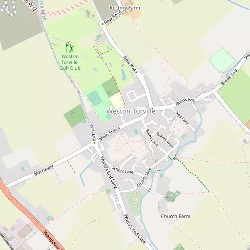
⇅
Location Summary
- Weston Turville is located in Buckinghamshire
- Administrative Area: Buckinghamshire
- Ceremonial County: Buckinghamshire
- Historic County: Buckinghamshire
- Region & Country: South East / England
⇅
Nearby Towns & Cities
- Wendover 3.4 km SSE
- Aylesbury 4.5 km NW
- Tring 6.8 km E
- Princes Risborough 8.8 km SSW
- Milton Keynes 28.1 km N


⇅
Nearby Localities
- West EndDistrict 386 m SSW
- Church EndDistrict 484 m SE
- Brook EndDistrict 634 m ENE
- Stoke MandevilleVillage 1.9 km W
- HaltonVillage 2.0 km SE
- Aston ClintonVillage 2.3 km NE
- BedgroveDistrict 2.3 km NW
- BroughtonVillage 3.1 km NNW
- TerrickVillage 3.3 km SSW
- BucklandVillage 3.6 km ENE


⇅
Smaller Settlements
- World's End 1.7 km SSE
- Nash Lee 3.2 km SSW
- North Lee 3.2 km WSW
- Chalkshire 3.6 km SSW
- Broughton Crossing 4.1 km NNW
- Marsh 4.3 km WSW
- Coombe 4.9 km SSW
- Puttenham 4.9 km NE
- Chivery 5.5 km SE
- Sedrup 5.6 km W

⇅
Beaches
- Bell Wharf Beach101.5 km ESE
- Cotswold Hills Beach83.8 km W
- Hadleigh Ray97.5 km ESE

⇅
Parks
- Balderson's Moor20.4 km ESE
- Chaulden Meadow18.6 km ESE
- Elfield Park25.3 km N
- Seabrook Meadow28.0 km E
⇅
Woods
- Engine House Belt2.1 km ESE
- Rosemead Covert2.1 km E
- Splash Covert1.5 km ENE
- Top Moors2.1 km SE
⇅
Hills
- Bacombe Hill3.9 km S
- Boddington Hill3.9 km SE
- Coombe Hill3.6 km ESE
- Haddington Hill4.0 km ESE

⇅
Lakes
- Mill Pond4.5 km SSW
- Oakfield Lake3.6 km NNW
- Weston Turville Reservoir1.4 km SSE
- Wilstone Reservoir5.5 km ENE
⇅
Waterfalls
- Neptune Waterfall18.9 km SE
- The Cascade31.6 km NNW
- Tower Waterfall18.2 km SE
⇅
Headlands
- Botany Bay Point43.6 km SSE
- Tripcock Ness66.6 km ESE
⇅
Islands
- China Island18.6 km WNW
- Grotto Island18.5 km WNW

⇅
Wetlands
- Cock Marsh24.2 km S
- Wargrave Marsh31.7 km SSW
- Ickenham Marsh34.6 km SE
⇅
Health Services
- Stoke Mandeville HospitalHospital 2.9 km WNW
- The Whiteleaf CentreHospital 4.4 km NW
- Freemantle CourtMedical 2.7 km SW
- Byron HouseMedical 3.3 km NW

⇅
Education
- Weston Turville Church of England SchoolSchool 216 m NNW
- Bedgrove Infant SchoolSchool 2.1 km NW
- Buckinghamshire New UniversityUniversity 4.2 km NW
⇅
Railway Stations
- Stoke Mandeville1.6 km WSW
- Wendover3.3 km SSE
⇅
Bus Stations
- Aylesbury Bus Station4.6 km NW
- High Wycombe Bus Station17.7 km S
⇅
Coach Stations
- High Wycombe Coachway19.6 km S
- Luton Airport Bus and Coach Station28.3 km ENE
⇅
Ferry Terminals
- Hammerton's Pier49.1 km SE
- Hampton Ferry Boathouse50.2 km SSE
⇅
Airports
- Wycombe Air Park20.3 km S
- London Luton Airport28.8 km ENE
⇅
Airfields
- Halton Airfield1.6 km E
- Holmbeck Farm Airfield13.5 km N
⇅
Heliports
- The London Heliport53.7 km SE
- Magpas Air Ambulance74.1 km NNE

⇅
Harbours
- Chelsea Harbour53.2 km SE
- Hendy's Quay106.0 km S