
Barbrook
About Barbrook
Barbrook sits within Devon. Among the nearby places are Lynmouth only 2.0 km North North East, Parracombe situated 5.2 km West South West, Simonsbath only 10.2 km South East and Bratton Fleming situated 12.4 km South West. Other rural places nearby include West Lyn, Cheriton, Furzehill, Countisbury and Rockford.
You may find extra local information by clicking a nearby place.
The place data here is drawn from OS, ONS and OSM under open licence.
⇅
Local Map
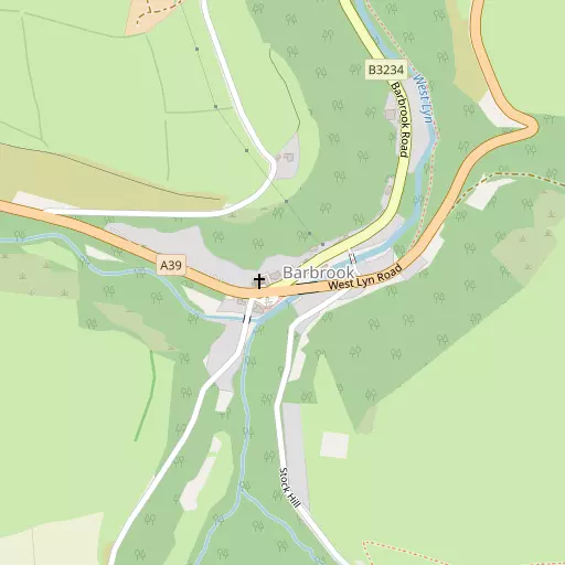
⇅
Location Summary
- Barbrook is located in Devon
- Administrative Area: Devon
- Ceremonial County: Devon
- Historic County: Devon
- Region & Country: South West / England
⇅
Nearby Towns & Cities
- Lynton 1.8 km NNE
- Ilfracombe 19.8 km W
- Barnstaple 21.1 km SW
- South Molton 21.8 km S
- Abertawe 45.7 km N


⇅
Nearby Localities
- LynmouthVillage 2.0 km NNE
- ParracombeVillage 5.2 km WSW
- SimonsbathVillage 10.2 km SE
- Bratton FlemingVillage 12.4 km SW
- Combe MartinVillage 13.0 km W
- BrayfordVillage 13.1 km S
- Stoke RiversVillage 14.7 km SSW
- Porlock WeirVillage 15.0 km E
- BerrynarborVillage 15.4 km W
- ShirwellVillage 15.6 km SW


⇅
Smaller Settlements
- West Lyn 1.1 km ENE
- Cheriton 2.3 km ESE
- Furzehill 2.8 km SSE
- Countisbury 3.8 km ENE
- Rockford 4.1 km E
- Wilsham 4.2 km ENE
- Martinhoe 4.8 km W
- Alderford 4.8 km E
- Brendon 5.5 km E
- Trentishoe 6.8 km W


⇅
Beaches
- Eastern Beach2.5 km NNE
- Sillery Sands3.4 km NE
- Western Beach2.3 km NNE

⇅
Parks
- Black Pill Burrows44.4 km NNW
- Lock's Common31.2 km NNE
- Pleasure Grounds54.3 km SSW
- The Warren15.9 km W

⇅
Woods
- Ilkerton Wood231 m SW
- Metticombe Wood192 m ESE
- Road Wood449 m NNE
- Stock Wood396 m S
⇅
Hills
- Barham Hill2.0 km SSW
- Hollerday Hill2.1 km N
- Summer House Hill1.8 km NE
- Wind Hill3.0 km NE
⇅
Lakes
- Bray Reservoir5.8 km SSW
- Long Pool3.9 km ENE
- Pinkworthy Pond5.4 km S
- Wistlandpound Reservoir9.1 km SW
⇅
Waterfalls
- Aberdulais Falls52.2 km N
- Berw-ddu59.7 km NNE
- Melin Court Waterfall55.1 km N
⇅
Headlands
- Duty Point2.8 km NW
- The Foreland5.0 km NE

⇅
Islands
- Burrow Nose16.0 km W
- Sexton's Burrow16.3 km W
⇅
Wetlands
- Ruddy Ball2.4 km N
- Point Perilous2.4 km NNE
- Gore Point14.4 km E
⇅
Health Services
- Ilfracombe Tyrrell HospitalHospital 19.7 km W
- North Devon District HospitalHospital 19.9 km SW
- Edenmore Nursing HomeMedical 19.4 km W
- Swimbridge House Nursing HomeMedical 19.5 km SSW
⇅
Education
- Lynton Church of England Primary SchoolSchool 1.8 km NNE
- Parracombe Church of England Primary SchoolSchool 5.2 km SW
- PetrocUniversity 22.3 km SW
⇅
Railway Stations
- Woody Bay3.5 km WSW
- Killington Lane4.7 km WSW
⇅
Bus Stations
- Barnstaple Bus Station21.2 km SW
- Gorsaf Fysiau Pen-y-Bont ar Ogwr37.5 km NNE
⇅
Coach Stations
- Torquay Coach Station85.0 km SSE
- Plymouth Coach Station95.9 km SSW
⇅
Ferry Terminals
- Starcross Pier70.9 km SSE
- Newport Transporter Bridge West71.4 km NE
⇅
Airports
- Cardiff Airport40.1 km ENE
- Swansea Airport46.0 km NNW
⇅
Airfields
- Chivenor Airfield25.6 km WSW
- Belle Vue Airfield31.6 km SW
⇅
Heliports
- Lake Heliport35.0 km SW
- Hartland Heliport51.9 km WSW
⇅
Harbours
- Lynmouth Harbour2.1 km NNE
- Watchet Harbour35.9 km E