
Brixworth
About Brixworth
Brixworth, in West Northamptonshire, has Pitsford lying 2.7 km South South East, Spratton lying 2.8 km West, Scaldwell around 3.0 km North East and Hanging Houghton around 3.2 km North North East. Other rural localities include Queen's Row, Teeton, Holdenby, Coton and Foxhall.
You may find out something new or interesting if you click a nearby place to see more local information.
Data shown here comes from OS, ONS and OSM under open licence, using the latest public sources available.
⇅
Local Map
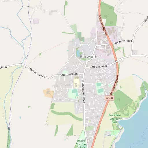
⇅
Location Summary
- Brixworth is located in West Northamptonshire
- Administrative Area: West Northamptonshire
- Ceremonial County: West Northamptonshire
- Historic County: West Northamptonshire
- Region & Country: East Midlands / England
⇅
Nearby Towns & Cities
- Northampton 10.1 km S
- Desborough 13.9 km NNE
- Kettering 14.5 km ENE
- Wellingborough 14.9 km E
- Milton Keynes 33.4 km SSE


⇅
Nearby Localities
- PitsfordVillage 2.7 km SSE
- SprattonVillage 2.8 km W
- ScaldwellVillage 3.0 km NE
- Hanging HoughtonVillage 3.2 km NNE
- CreatonVillage 4.2 km WNW
- LamportVillage 4.4 km NNE
- CottesbrookeVillage 4.5 km NW
- Chapel BramptonVillage 4.6 km SSW
- HolcotVillage 4.7 km ESE
- OldVillage 4.7 km ENE


⇅
Smaller Settlements
- Queen's Row 3.0 km W
- Teeton 5.1 km W
- Holdenby 5.6 km WSW
- Coton 7.2 km W
- Foxhall 8.2 km NNE
- Nobottle 10.4 km SW
- Orton 10.7 km NE
- Thorpe Underwood 11.2 km NNE
- Winwick 12.4 km WNW
- Swan Valley 12.9 km SSW


⇅
Beaches
- Cotswold Hills Beach103.4 km SW
- Snettisham Beach109.0 km ENE
- Snettisham Scalp109.4 km NE
⇅
Parks
- Buckwell Green14.2 km E
- Foot Meadow10.2 km S
- The Green12.2 km SSW
- The Green21.8 km WSW
⇅
Woods
- Circular Spinney3.5 km SW
- Clint Hill Fox Covert2.8 km N
- Creaton Covert3.2 km NW
- Long Plantation3.5 km NNE

⇅
Hills
- Bickle Hill4.6 km WNW
- Brampton Hill4.8 km SW
- Clint Hill3.1 km N
- Hoe Hill3.5 km SW
⇅
Lakes
- Pitsford Water3.8 km E
- River Nene Brampton Branch3.6 km N
- Scaldwell Arm3.1 km E
- Walgrave Arm4.3 km E
⇅
Waterfalls
- Neptune Waterfall76.2 km SSE
- The Cascade34.3 km SSW
- Tower Waterfall75.7 km SSE
⇅
Headlands
- Botany Bay Point104.1 km SSE
- Tripcock Ness114.0 km SE

⇅
Islands
- Heron Island25.2 km ESE
- Millholme Island24.8 km SE
⇅
Wetlands
- Summer Leys15.5 km ESE
- Lucas Marsh31.7 km NNW
- Wyken Slough40.4 km WNW

⇅
Health Services
- John Greenwood Shipman CentreHospital 8.1 km SE
- Berrywood HospitalHospital 9.7 km SSW
- Pytchley Court Nursing HomeMedical 478 m SSE
- Kingsthorpe Grange Nursing HomeMedical 6.2 km S
⇅
Education
- Brixworth Church of England (Voluntary Controlled) Primary SchoolSchool 187 m SSE
- Pitsford Primary SchoolSchool 2.7 km SSE
- Northampton School of PodiatryUniversity 10.5 km S
⇅
Railway Stations
- Pitsford and Brampton4.0 km SSW
- Boughton5.2 km S
⇅
Bus Stations
- North Gate Bus Station9.9 km S
- Daventry Bus Station19.0 km WSW
⇅
Coach Stations
- Milton Keynes Coachway33.4 km SSE
- Shakespeare's Birthplace Coach Terminal56.7 km WSW
⇅
Ferry Terminals
- Normanton Chain Ferry57.0 km NNW
- Embankment Pier106.0 km SSE
⇅
Airports
- Coventry Airport39.4 km W
- Wellesbourne Mountford Airfield50.3 km WSW
⇅
Airfields
- Sywell Aerodrome8.2 km ESE
- Deenethorpe Airfield29.0 km NE
⇅
Heliports
- Magpas Air Ambulance45.0 km E
- Nottingham Heliport57.4 km N
⇅
Harbours
- Farndon Harbour81.9 km N
- Chelsea Harbour107.1 km SSE