
Broadholme
About Broadholme
Broadholme is in Lincolnshire. Nearby places include Saxilby situated 1.3 km North, Thorney situated 3.5 km West South West, Harby lying 3.6 km South South West, Ingleby lying 3.8 km North and Skellingthorpe just 3.9 km South East. Other rural settlements include Drinsey Nook, Hardwick, Broxholme and Thorney Moor.
You may notice something interesting if you explore one of the nearby places.
These details are compiled from OS, ONS and OSM data released under open licence.
⇅
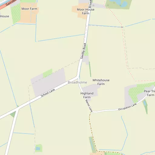
Local Map
⇅
Location Summary
- Broadholme is located in Lincolnshire
- Administrative Area: Lincolnshire
- Ceremonial County: Lincolnshire
- Historic County: Lincolnshire
- Region & Country: East Midlands / England
⇅
Nearby Towns & Cities
- North Hykeham 8.9 km SSE
- Gainsborough 17.5 km NNW
- Retford 19.9 km WNW
- Newark-on-Trent 22.4 km SSW
- Lincoln 8.7 km ESE


⇅
Nearby Localities
- SaxilbyVillage 1.3 km N
- Thorney Village 3.5 km WSW
- Harby Village 3.6 km SSW
- InglebyVillage 3.8 km N
- SkellingthorpeVillage 3.9 km SE
- JerusalemDistrict 4.0 km SE
- Burton WatersVillage 4.3 km E
- DoddingtonVillage 4.4 km S
- Wigsley Village 5.1 km SW
- FentonVillage 5.1 km WNW


⇅
Smaller Settlements
- Drinsey Nook 2.0 km W
- Hardwick 2.7 km WNW
- Broxholme 3.5 km NE
- Thorney Moor 4.1 km SW
- Bransby 4.8 km N
- Kettlethorpe 4.8 km WNW
- Swinethorpe 5.1 km SSW
- Westwoods 6.1 km NNW
- Thorpe le Fallows 6.8 km NNE
- Brampton 7.1 km NW


⇅
Beaches
- Cleethorpes Beach54.5 km NE
- Ellerker Foreshore52.6 km N
- Whitgift Sand49.6 km N
⇅
Parks
- Burgage Green27.4 km SW
- Doncaster Common40.8 km NW
- Killamarsh Meadows44.3 km W
- Wilsford Warren33.6 km SSE
⇅
Woods
- Broadholme Gorse1.1 km S
- Gibbet Wood1.5 km WSW
- Glover's Wood2.1 km WSW
- Skellingthorpe Big Wood2.4 km SE
⇅
Hills
- Clifton Hill8.3 km WSW
- Magtree Hill1.8 km SE
- Slack's Hill8.0 km SSW
- Strunch Hill4.0 km S
⇅
Lakes
- Ballast Holes7.1 km ESE
- Burton Waters4.7 km ESE
- Hall Water Reservoir6.7 km W
- Hartsholme Lake6.7 km SE
⇅
Waterfalls
- Goitstock Waterfall102.5 km NW
- Kinder Downfall82.1 km WNW
- Lumb Fall98.0 km WNW
⇅
Headlands
- Flamborough Head102.8 km NNE
- Red Cliff Point111.4 km N
⇅
Islands
- Branston Island20.9 km E
- Torksey Island7.5 km NW
⇅
Wetlands
- Laughterton Marsh7.1 km WNW
- Smithy Marsh11.3 km SW
- Lea Marsh14.6 km NNW
⇅
Health Services
- Lincoln Private HospitalHospital 9.0 km ESE
- Lincoln County HospitalHospital 10.0 km ESE
- The Grove Nursing HomeMedical 3.9 km SE
- White Gables Care HomeMedical 4.9 km ESE
⇅
Education
- The Saxilby Church of England Primary SchoolSchool 1.4 km NNE
- Burton Hathow Preparatory SchoolSchool 2.7 km ENE
- University of LincolnUniversity 8.0 km ESE

⇅
Railway Stations
- Saxilby1.1 km N
- Hykeham8.1 km SSE
⇅
Bus Stations
- Lincoln Central Bus Station9.1 km ESE
- Retford Bus Station19.7 km WNW
⇅
Coach Stations
- Chesterfield Coach Station51.0 km W
- Meadowhall Interchange52.8 km WNW
⇅
Ferry Terminals
- Hull Ferry Port59.6 km NNE
- Normanton Chain Ferry63.4 km SW
⇅
Airports
- Wickenby Aerodrome21.8 km ENE
- Doncaster Sheffield Airport33.3 km NW
⇅
Airfields
- RAF Waddington13.7 km SE
- Sturgate Airfield13.9 km N
⇅
Heliports
- Lincs and Notts Air Ambulance HQ14.1 km SE
- Nottingham Heliport52.6 km SSW
⇅
Harbours
- Farndon Harbour24.9 km SSW
- South Killingholme Haven52.2 km NE