
Cheriton Bishop
About Cheriton Bishop
Cheriton Bishop is in Devon. Nearby places include Crockernwell just 2.1 km West South West, Tedburn St Mary lying 4.2 km East North East, Drewsteignton just 4.3 km West South West and Hittisleigh Barton lying 4.5 km West North West. Other rural localities include Woodland Head, Preston, Hittisleigh, Neopardy and Westcott.
You may find extra local information by clicking a nearby place.
These details are compiled from OS, ONS and OSM data released under open licence.
⇅
Local Map
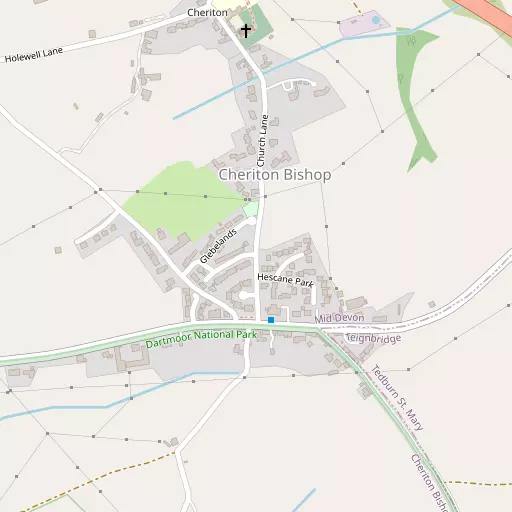
⇅
Location Summary
- Cheriton Bishop is located in Devon
- Administrative Area: Devon
- Ceremonial County: Devon
- Historic County: Devon
- Region & Country: South West / England
⇅
Nearby Towns & Cities
- Moretonhampstead 7.3 km SSW
- Chagford 9.2 km SW
- Crediton 9.3 km NE
- North Tawton 13.9 km NW
- Exeter 14.5 km E


⇅
Nearby Localities
- CrockernwellVillage 2.1 km WSW
- Tedburn St MaryVillage 4.2 km ENE
- DrewsteigntonVillage 4.3 km WSW
- Hittisleigh BartonDistrict 4.5 km WNW
- DunsfordVillage 5.1 km SE
- YeofordVillage 5.7 km N
- Pathfinder VillageVillage 6.6 km E
- ColebrookeVillage 6.9 km N
- ColefordVillage 7.9 km N
- BridfordVillage 8.0 km SE


⇅
Smaller Settlements
- Woodland Head 3.5 km N
- Preston 3.6 km SW
- Hittisleigh 4.5 km WNW
- Neopardy 6.2 km NNE
- Westcott 6.3 km SSE
- Doccombe 6.3 km S
- Venny Tedburn 6.5 km NE
- Westwoods 6.5 km E
- The Crescent 6.6 km E
- Long Woods 6.6 km E


⇅
Beaches
- Cockle Sand24.5 km ESE
- Powderham Sand21.6 km ESE
- Starcross Sand23.1 km ESE

⇅
Parks
- Palm Cross Green43.0 km SSW
- Pennsylvania Park15.4 km E
- Pleasure Grounds18.2 km W
- The Lawn24.9 km SE

⇅
Woods
- Meadwell Plantation1.1 km NNW
- Southdown Plantation1.2 km NNE
- Tinker's Grove Plantation1.0 km S
- Windmill Down Plantation856 m SE

⇅
Hills
- Butterdon Hill5.2 km SSW
- France Hill7.7 km WSW
- Hingston Down7.2 km S
- Mardon Down6.1 km S
⇅
Lakes
- Binneford3.9 km NNW
- Bradford Pool7.6 km WSW
- Bridford Reservoir7.6 km SSE
- The Lake2.4 km SE
⇅
Waterfalls
- Becka Falls13.1 km S
- Broad Falls28.7 km SSW
- Horseshoe Falls23.5 km SSW
⇅
Headlands
- Hole Head26.1 km SE
- The Ness26.9 km SE
⇅
Islands
- Bellpool Island23.1 km SSW
- Island of Rocks21.6 km W
⇅
Wetlands
- Whitemoor Marsh12.9 km WSW
- Raybarrow Pool13.8 km WSW
- Taw Marsh15.3 km W
⇅
Health Services
- Moretonhampstead HospitalHospital 7.2 km SSW
- Crediton HospitalHospital 8.8 km NNE
- Langford ParkMedical 13.5 km ENE
- Barton PlaceMedical 14.0 km E
⇅
Education
- Cheriton Bishop Community Primary SchoolSchool 498 m N
- Tedburn St Mary SchoolSchool 4.3 km ENE
- Duryard Halls of ResidenceUniversity 13.9 km E
⇅
Railway Stations
- Yeoford5.9 km N
- Crediton9.2 km NE
⇅
Bus Stations
- Exeter Bus Station15.2 km E
- Barnstaple Bus Station45.2 km NNW
⇅
Coach Stations
- Torquay Coach Station31.3 km SSE
- Plymouth Coach Station48.5 km SW
⇅
Ferry Terminals
- Starcross Pier23.4 km ESE
- Greenway Quay39.5 km SSE
⇅
Airports
- Exeter Airport23.0 km E
- Plymouth City Airport42.5 km SW
⇅
Airfields
- Eggesford Airfield18.1 km NNW
- Eaglescott Airfield28.6 km NW
⇅
Heliports
- Lake Heliport49.6 km NW
- Hartland Heliport63.7 km WNW
⇅
Harbours
- Lympstone Boat Shelter23.2 km ESE
- Old Harbour33.1 km SSE