
Feock
About Feock
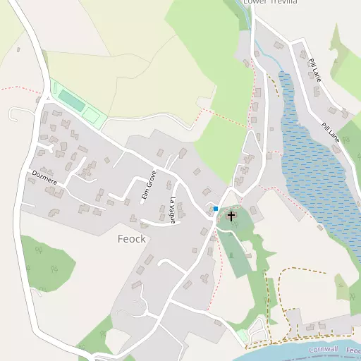
Feock, in Cornwall, has Harcourt around 1.3 km South South West, Trolver Croft lying 1.4 km West, Penelewey lying 2.0 km North North West and Mylor Bridge around 2.9 km South West. Other rural localities include Goonpiper, Trelissick, Restronguet Weir, Restronguet Barton and Coombe.
You may find extra local information by clicking a nearby place.
This page uses OS, ONS and OSM data supplied under open licence.
⇅
Local Map
⇅
Location Summary
- Feock is located in Cornwall
- Administrative Area: Cornwall
- Ceremonial County: Cornwall
- Historic County: Cornwall
- Region & Country: South West / England
⇅
Nearby Towns & Cities


⇅
Nearby Localities
- HarcourtVillage 1.3 km SSW
- Trolver CroftVillage 1.4 km W
- PeneleweyVillage 2.0 km NNW
- Mylor BridgeVillage 2.9 km SW
- Carnon DownsVillage 3.0 km NW
- DevoranVillage 3.1 km WNW
- Playing PlaceVillage 3.2 km NNW
- TrelewVillage 3.3 km SSW
- St Just in RoselandVillage 4.0 km SE
- RingwellVillage 4.1 km WNW


⇅
Smaller Settlements
- Goonpiper 963 m NNW
- Trelissick 1.7 km NE
- Restronguet Weir 1.9 km SSW
- Restronguet Barton 2.3 km SSW
- Coombe 2.6 km NNE
- Mylor Churchtown 3.3 km S
- Carclew 3.6 km W
- Old Kea 3.8 km NNE
- Kea 4.4 km NNW
- Calenick 4.6 km N


⇅
Beaches
- Loe Beach503 m SSE
- Tavern Beach6.0 km SSE
- Well Beach5.5 km SSW

⇅
Parks
- Lanner Moor10.3 km W
- Palm Cross Green84.1 km ENE
- Summerleaze Down78.3 km NNE
- Trungle Moor38.0 km WSW


⇅
Woods
- Lodge Plantation1.4 km NNE
- Nullas Plantation937 m NE
- Pill Plantation712 m ESE
- Waterloo Plantation1.5 km NNW

⇅
Hills
- Carn Marth11.1 km W
- Carnmenellis12.9 km WSW
- Puckey's Hill11.7 km E
- Tubbon Hill8.2 km W

⇅
Lakes
- College Reservoir7.5 km SW
- Merther Pond6.1 km NNE
- Swan Pool7.3 km SSW
- Tresemple Pond6.8 km NNE
⇅
Waterfalls
- Golitha Falls49.9 km NE
- White Lady Waterfall81.1 km NE
- Yealm Steps83.0 km ENE
⇅
Headlands
- Messack Point3.3 km SE
- Restronguet Point1.1 km SSW
⇅
Islands
- Porth Island24.5 km N
- The Island23.4 km N
⇅
Wetlands
- Pill Point664 m SE
- Turnaware Point1.2 km ESE
- Weir Point1.8 km SSW
⇅
Health Services
- Falmouth HospitalHospital 6.2 km SSW
- Treliske HospitalHospital 7.2 km NNW
- Eshcol HouseMedical 6.1 km ESE
- King Charles Court Nursing HomeMedical 6.1 km SSW
⇅
Education
- Mylor Bridge Primary SchoolSchool 2.9 km SW
- Devoran SchoolSchool 3.0 km WNW
- Falmouth Marine SchoolUniversity 6.2 km SSW
⇅
Railway Stations
- Perranwell4.4 km WNW
- Penryn5.8 km SW
⇅
Bus Stations
- Truro Bus Station6.2 km N
- Camborne Bus Station17.6 km W
⇅
Coach Stations
- Plymouth Coach Station67.1 km ENE
- Torquay Coach Station111.6 km ENE
⇅
Ferry Terminals
- Trelissick2.0 km NE
- Philleigh2.2 km ENE
⇅
Airports
- Newquay Cornwall Airport26.2 km N
- Land's End Airport45.7 km WSW
⇅
Airfields
- Truro Airfield10.2 km NW
- Perranporth Airfield16.5 km NNW
⇅
Heliports
- Cornwall Air Ambulance Station25.6 km N
- Penzance Heliport33.9 km WSW
⇅
Harbours
- Penryn Harbour5.1 km SSW
- South Harbour5.6 km SW