
Gorran Haven
About Gorran Haven
Gorran Haven is in Cornwall. Local places nearby include Gorran Churchtown just 1.5 km West North West, Portmellon lying 2.4 km North, Trevarth Estate around 3.3 km North and Mevagissey situated 3.4 km North. Other rural settlements include Penare, Boswinger, Treveor, Tregavarras and Rescassa.
You may find extra local information by clicking a nearby place.
The place data here is drawn from OS, ONS and OSM under open licence.
⇅
Local Map
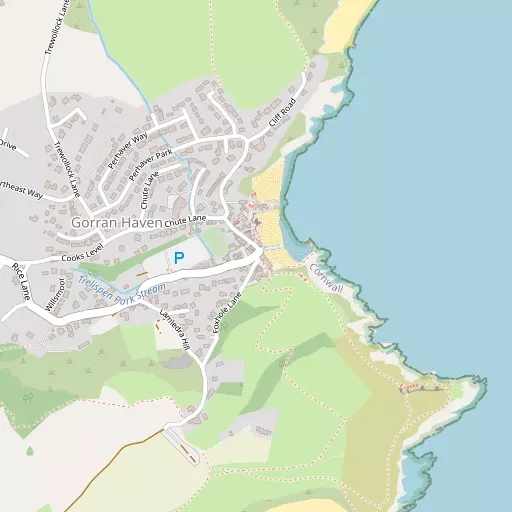
⇅
Location Summary
- Gorran Haven is located in Cornwall
- Administrative Area: Cornwall
- Ceremonial County: Cornwall
- Historic County: Cornwall
- Region & Country: South West / England
⇅
Nearby Towns & Cities
- St Austell 10.9 km N
- St Blazey 14.4 km NNE
- Fowey 15.1 km NE
- Lostwithiel 20.4 km NNE
- Truro 18.9 km W


⇅
Nearby Localities
- Gorran ChurchtownVillage 1.5 km WNW
- PortmellonDistrict 2.4 km N
- Trevarth EstateDistrict 3.3 km N
- MevagisseyVillage 3.4 km N
- PentewanVillage 5.7 km N
- PortloeVillage 7.5 km WSW
- London ApprenticeVillage 8.4 km N
- PolgoothVillage 9.1 km NNW
- StickerVillage 9.3 km NNW
- TregonyVillage 9.4 km WNW


⇅
Smaller Settlements
- Penare 1.7 km SW
- Boswinger 2.2 km W
- Treveor 2.6 km W
- Tregavarras 3.1 km W
- Rescassa 3.2 km WNW
- Trevarrick 3.4 km WNW
- Kestle 4.2 km NNW
- Tregiskey 4.8 km N
- St Michael Caerhays 5.0 km W
- East Portholland 5.4 km W

⇅
Beaches
- Gorran Haven Beach76 m ENE
- Great Perhaver Beach712 m NNE
- Little Perhaver Beach206 m NNE

⇅
Parks
- Lanner Moor29.1 km W
- Palm Cross Green64.9 km E
- Summerleaze Down68.0 km NNE
- Trungle Moor56.9 km WSW

⇅
Woods
- Battery Walk Wood4.1 km W
- Forty Acre Wood3.8 km W
- Galowras Wood2.4 km NNW
- Treleaven Plantation3.9 km NNW
⇅
Hills
- Castle Hill2.5 km NNW
- Crow Hill12.0 km NW
- Puckey's Hill7.5 km WSW
- Sticker Down9.2 km NNW

⇅
Lakes
- Carpalla Mica Dam13.4 km NNW
- Hill's Quarry10.7 km N
- Lizard Pool2.6 km SSW
- Trethurgy Reservoir12.7 km N

⇅
Waterfalls
- Golitha Falls34.2 km NE
- White Lady Waterfall64.2 km NE
- Yealm Steps64.2 km ENE
⇅
Headlands
- Bodrugan's Leap1.9 km NE
- Pen-a-maen561 m SE

⇅
Islands
- Gull Island10.9 km NNE
- St George's Island26.3 km ENE
⇅
Wetlands
- The Battery3.4 km N
- Appletree Point10.5 km NNE
- Gidleywell11.0 km WSW
⇅
Health Services
- Penrice HospitalHospital 9.7 km N
- Fowey HospitalHospital 15.2 km NE
- Roseland Parc Nursing HomeMedical 9.2 km WNW
- Roseland CareMedical 9.2 km WNW
⇅
Education
- Gorran SchoolSchool 1.5 km W
- Mevagissey Community Primary SchoolSchool 4.0 km N
- Falmouth UniversityUniversity 22.5 km WSW
⇅
Railway Stations
- St Austell11.0 km N
- Par14.2 km NNE
⇅
Bus Stations
- Truro Bus Station18.7 km W
- Newquay Bus Station28.6 km NW
⇅
Coach Stations
- Plymouth Coach Station48.1 km ENE
- Torquay Coach Station92.5 km ENE
⇅
Ferry Terminals
- Polruan Ferry14.7 km NE
- Fowey Quay14.9 km NE
⇅
Airports
- Newquay Cornwall Airport27.5 km NW
- Plymouth City Airport52.3 km ENE
⇅
Airfields
- Truro Airfield25.5 km W
- Perranporth Airfield29.5 km WNW
⇅
Heliports
- Cornwall Air Ambulance Station25.5 km NNW
- Penzance Heliport53.0 km WSW
⇅
Harbours
- The Pool3.2 km N
- Mevagissey Harbour3.2 km N