
Great Paxton
About Great Paxton
Great Paxton sits within Cambridgeshire. Among the nearby places are Little Paxton lying 2.5 km West South West, Offord D'Arcy around 2.7 km North North East, Southoe situated 2.7 km West North West and Toseland situated 3.1 km East South East. Other places in the surrounding countryside include Diddington, Stirtloe, Wintringham, Weald and Hardwick.
You may find extra local information by clicking a nearby place.
The place data here is drawn from OS, ONS and OSM under open licence.
⇅
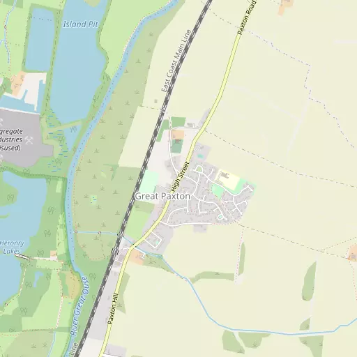
Local Map
⇅
Location Summary
- Great Paxton is located in Cambridgeshire
- Administrative Area: Cambridgeshire
- Ceremonial County: Cambridgeshire
- Historic County: Cambridgeshire
- Region & Country: Eastern / England
⇅
Nearby Towns & Cities
⇅
Nearby Localities
⇅
Smaller Settlements
⇅
Beaches
- Snettisham Beach
- Snettisham Scalp
- Stubborn Sand
⇅
Parks
- Butt Green
- Empty Common
- New Pasture
- Wimpole Park
⇅
Woods
- Cromwell's Close Plantation
- Hawkesden Leys Plantation
- Lodge Plantation
- Toseland Wood
⇅
Hills
- Buckden Hill
- Duloe Hill
- Paxton Hill
- Thistle Hill
⇅
Lakes
- Heronry North Lake
- Heronry South Lake
- Paxton Pits
- Weedy Lake
⇅
Waterfalls
- Neptune Waterfall
- The Cascade
- Tower Waterfall
⇅
Headlands
- Botany Bay Point
- Tripcock Ness
⇅
Islands
- Battcock's Island
- The Island
⇅
Wetlands
- Ouse Fen
- Fowlmere
- Chesterton Fen
⇅
Health Services
- Hinchingbrooke Hospital
- Biggleswade Hospital
- Henbrook House
- Eltisley Manor
⇅
Education
- Great Paxton Church of England Primary School
- Little Paxton Primary School
- Madingley Hall
⇅
Railway Stations
- St Neots
- Huntingdon
⇅
Bus Stations
- Huntingdon Bus Station
- Drummer Street Bus Station
⇅
Coach Stations
- Milton Keynes Coachway
- Luton Airport Bus and Coach Station
⇅
Ferry Terminals
- Blackfriars Pier
- Embankment Pier
⇅
Airports
- Cambridge City Airport
- London Luton Airport
⇅
Airfields
- RAF Alconbury
- Little Grandsden Airfield
⇅
Heliports
- Magpas Air Ambulance
- The Egerton-Smith Centre
⇅
Harbours
- Chelsea Harbour
- Farndon Harbour